The Basics of Navigation
Critical Skills for All Sailors and Other Boaters
- Snowboarding
- Scuba Diving & Snorkeling
This article describes the basics of how to navigate in your own boat using either traditional paper charts or a chartplotter or charting app. Navigation skills are critical for sailors and other boaters to avoid problems with underwater obstructions and to reach the intended destination safely and efficiently. Many boats - and lives - have been lost due to poor navigation, even with modern electronics that most boaters now take for granted and feel confident will guide them faultlessly through the water. Regardless, attention and navigation skills remain crucial for boaters in all but the most known waters.
We'll look at the two most important dimensions of navigation: knowing where you are at any given moment, and knowing which way to steer to best reach the intended destination. Both aspects vary depending on whether you are using traditional paper charts or a chartplotter or app, but even with good electronic aids, most boaters still should understand the traditional methods simply because electronics so often fail in marine environments.

Traditional Navigation with Paper Charts
The safest thing is to always carry and know how to use paper charts, even if you use a GPS-enabled chartplotter or app. Have recent charts at the appropriate scale. Buy recent charts locally or download NOAA paper chart booklets and print them out yourself.
When in sight of land, maintain a sense of your current position at all times by observing aids to navigation (such as green and red buoys or the flash of a lighthouse or lighted buoy) and taking compass bearings to obvious shore features. For example, you might observe a water tower at 270 degrees and a small island at 40 degrees. Using parallel rules lined up with the correct angles on the compass rose on the chart, pencil in the bearing lines back from both these features, and where the lines cross is, theoretically, your approximate position. Three lines of bearing are more accurate.
To plot your course, pencil in a line from your present position to your destination, or to a point where you need to turn to avoid an obstruction, go around a headland or island, etc. (Such points are called waypoints.) Using the parallel rules, walk the line over to the compass rose to determine the direction to steer. Then use dividers or a ruler to measure the approximate distance to that point, and - assuming you know your boatspeed - determine the time it will take to reach it. You can then "dead reckon" your moving position along that line based on your speed and the passage of time. Continue to take bearings to confirm your changing position and to ensure you stay on the course line.
Never assume, however, that the boat is moving on your plotted course line just because you are steering in the correct direction. A current could be sweeping you off course to one side, and a sailboat always makes some leeway (side-slipping downwind).
Navigation with Chartplotters and Apps
Chartplotters and navigational charting apps show your boat's position superimposed on the chart on the screen, making it easy to see where you are. With this information you can in some cases simply eyeball your destination and route and follow your progress safely over the chart. With more distant or complicated destinations you can enter waypoints into the chartplotter or app and build a route, which typically is shown as a line on the chart screen that you simply steer along. As long as you constantly observe your position on the chart and steer appropriately to avoid hazards, it would seem that little could go wrong. In fact, many boats still get in trouble by going off course unaware, due to less than perfect steering or a side current. Again, learn how to compensate for a current . Look behind you as well as ahead to detect whether you are still on the straight line between points, that you haven't been swept to one side possible toward unseen rocks. Even when using chartplotters many boaters have been swept off course and into a hazard simply because it can happen very fast and because many boaters do not bother to plot route lines that visibly demonstrate whether they are still on that straight line to the next waypoint. Overconfidence can cause many problems, especially in the minutes immediately following an electronics failure when you may need to act quickly to avoid a hazard. Experienced sailors using a chartplotter often still keep a paper chart in the cockpit so that they are able at any moment to switch to chart navigation skills if the plotter suddenly stops.
Other Aids to Navigation
Finally, it's a good idea to be aware of other aids to navigation, as used by traditional mariners for hundreds of years. This can be as simple as estimating current speeds by observing the action of moving water on a nearby buoy or lobster or crab pot float. When you are familiar with your boat's motion and speed, you can learn to gauge boatspeed by the appearance of water flowing past your hull - and use this same appearance to extrapolate the speed and effect of a current by observing the water flowing around a buoy.
Another navigational aid is the boat's depthfinder. Simply comparing your measured depth with the depth shown on the chart helps confirm your approximate position when using traditional paper charts. This article describes in more detail how to use your depthfinder for navigation. If you don't have a depthfinder on your boat, you can easily install an inexpensive one yourself. Even with a chartplotter, which can be off by short distances in showing your position, a depthfinder is often important for safe navigation.
- Best Sailing and Boating Apps
- Marine Navigation
- Using AIS on Your Sailboat
- Learn How to Sail a Small Sailboat – 1. The Parts of the Boat
- How to Gybe a Sailboat
- Drive That Tube/Towable to Work Behind the Boat
- How to Heave To a Sailboat
- How to Anchor a Sailboat
- Raster versus Vector Charts in Nautical Use
- Magic Spot Advice For A Multi-Rail Bank Shot
- Golf Cart Etiquette and Rules of the Road
- How to Boat
- How to Ride a Motorcycle in 10 Simple Steps
- ABS Brakes and the Facts
- Navy Careers: What You Need to Know About Navy Enlisted Ratings
- Etiquette for Your First Round of Golf

- Subscribe Now
- Digital Editions
Best boat GPS: 6 handheld options for navigation at sea
We take a look at 6 of the best boat GPS options available right now, from handheld devices to tablet apps
‘Lost at Sea’ might be a great name for a video game, but in real life the prospect of losing one’s bearings on the ocean can be pretty scary indeed. Chartplotters can – and sometimes do – fail, (it’s happened to this writer), leaving you alone with a compass and, if you’ve prepared, a set of charts to guide you to a safe haven – assuming you know, or can remember, how to navigate manually, that is…
And that, in a nutshell, is why many mariners today choose not to leave port without a backup or secondary system aboard. Happily, reserve navigation aids no longer need to be big to be beautiful as now there’s a range of powerful pocket sized devices available which put GPS technology in the palm of your hand – literally.
What’s more, these devices come in a variety of forms and formats, such as purpose-built handheld boat GPS units, GPS-equipped VHF radios and smartphone/tablet-based app setups. Incidentally, just a note on those phones and tablets: If you’re planning to use one as your primary navigation tool, do bear in mind battery time is sure to be compromised by any power-hungry application.
Looking for Christmas gift inspiration? Check out our guide to the best Christmas gifts for boaters
While handheld GPS systems are intended more to complement chartplotters rather than replace them, there are certain tasks where they leave fixed units standing. Consider, for example, overnighting at anchor. If the boat’s chartplotter is helm-mounted there’s a good chance the cabins will be out of earshot of its anchor-drag alarm.
Recommended videos for you
A handheld, however, can join you at bedtime and, should the need arise, will disturb your slumber with an alarm that will send you dashing up to the deck at the double to see what’s going on. And that alone could be a factor to persuade many boaters to consider investing in a handheld GPS system. Here’s our selection of six of the best boat GPS systems on offer today.
At a glance: Garmin GPSMAP86i – Best boat GPS- Buy it now Icom IC-M94DE – Best marine handheld VHF – Buy it now Garmin GPSMAP 78 – Best boat GPS for all weather – Buy it now Standard Horizon HX890E – Best boat GPS for multiple routes – Buy it now
Best boat GPS systems available right now

Garmin GPSMAP 86i
Specifications: Screen size – 3 inches, battery life – 200 hours, adjustable GPS filter
Reasons to buy: State-of-the-art, IPX7 waterproof rating, doubles up as a satellite phone
Reasons to avoid: Premium price, subscription required for satellite feature
Garmin dominates the purpose-built handheld boat GPS market and its GPSMAP 86i unit very much represents the state-of-the-art. Bristling with features, including a 3″ display which is bright enough to be readable in sunlight, the 86i has an IPX7 rating meaning it can withstand exposure to 1 metre of water for up to 30 minutes.
This boat GPS unit supports Garmin’s BlueChart g3 charts and is capable of streaming boat data from compatible plotters and instruments to place important information in your hand no matter where on the boat you happen to be. The 86i also doubles up as a satellite phone via the inReach network, for which a separate subscription is required.
Buy it now on Garmin.com
Buy it now on Amazon (UK)
Buy it now on Amazon (US)
Note: We may earn a commission when you buy through links on our site, at no extra cost to you. This doesn’t affect our editorial independence.

Icom IC-M94DE handheld marine radio
Specifications: 1 Lithium Ion battery required, VHF tuner technology, noise cancellation
Reasons to buy: Full DSC functionality, built-in AIS receiver
Reasons to avoid: Limited navigation capabilities
Icom’s IC-M94DE VHF radio puts power in your hand in a number of ways. For in addition to GPS, it has full DSC functionality and is the world’s first marine handheld VHF to incorporate a built-in AIS receiver .
The GPS part of the package allows the user to store up to 50 waypoints. While the unit’s navigation capabilities are limited, what the M94DE can do is provide a much needed confidence boost for anyone who finds themselves at sea without an alternative nav system.
That’s because the radio’s navigation function guides the user to the selected waypoint and provides a reassuring beep once it has been reached, thereby confirming the boat’s position at sea.
Read our Icom IC-M94DE review
Buy it now on Amazon

Garmin GPSMAP 78
With its bright colour screen and IXP7 waterproof rating, Garmin’s GPSMAP 78 is a great handheld boat GPS choice. Ruggedly constructed with moulded rubber side grips, the unit feels good in the hand.
That said, should you manage to drop it in the briny, fear not – it floats. The GPSMAP 78 has a sensitive WAAS-enabled GPS receiver which locates its position quickly and efficiently once switched on.
It’s supplied with a worldwide basemap which can be added to by simply plugging in a pre-loaded Garmin BlueChart g2 map. And when you’ve finished having fun on the water, the boat GPS unit connects to your PC and the internet for a detailed analysis of the day’s action.
Reasons to buy: Rugged construction, IXP7 Waterproofing, Can plug into PC for statistics
Reasons to avoid: Additional maps are costly
Specifications: Battery life – 20 hours, barometric altimeter, 2 AA batteries required (included)

Standard Horizon HX890E VHF handheld marine radio
Similar in principle to the Icom M94DE, but costing considerably less (due to no AIS receiver) Standard Horizon’s GPS-equipped HX890DE VHF radio is capable of storing up to 250 waypoints.
Another factor well worth bearing in mind is that this radio does routes. Up to 30 waypoints can be tagged to create a passage, which can then be followed automatically or manually.
Setting all of this up can be somewhat burdensome, especially given the screen size is just 1.7″ square, but once programmed the routing functionality of the HX890E could well make the difference between a relaxed or stressful journey.
Reasons to buy: Up to 250 waypoints, has ability to set up routes
Reasons to avoid: Small screen, hard to set-up
Specifications: 66 channels, 1 battery required, water activated strobe light

Garmin GPS 73
The Garmin GPS 73 is an easy-to-use handheld navigator. The unit can mark and store up to 1,000 waypoints and 100 tracks, making return navigation simple.
It also features SailAssist, which is designed to help the user sail more efficiently with a heading line and tack assist, which essentially lets you know when to tack.
Other in-built features include sunrise/sunset, estimated time of arrival and various marine data. The relatively low price point reflects the fact that the GPS 73 boat GPS comes with a monochromatic display. That said, the screen is high contrast and can be read in all lighting conditions. There’s also a built-in back light for operation after dark.
Reasons to buy: Ease of us, great price, SailAssist
Reasons to avoid: Small screen without colour
Specifications: 18 hours battery life, GPS 73, nautical map type

Navionics Boating App
Navionics is a Garmin brand, so the charts used by its Boating Marine and Lakes app will look familiar to existing Garmin plotter users. Compatible with both Android and Apple devices, this popular boating app can be downloaded from Google Play or the App Store .
Once installed, maps are downloaded and stored on your device, allowing offline access at all times. As you would expect from anything to do with Garmin, the app has a multitude of features, including tracks, routing, dock-to-dock autorouting, tides and weather information and SonarChart, which provides high definition bathymetric mapping.
What’s more, Navionics’ charts are updated up to 5,000 times a day and the system embraces community edits to ensure valuable local information is kept up-to-date and relevant at all times.
Reasons to buy: Compatible with Android and Apple, Garmin style features, updated 5,000 times a day
Reasons to avoid: Requires your own device, Subscription model
Download from Google Play
Download from the App Store
Didn’t find what you’re looking for? Head to Amazon’s dedicated boating page for more marine products.
Palm Beach Boat Show hotels for last minute local accommodation
Looking for boot düsseldorf hotels look no further…, looking for hotels near miami boat show look no further…, latest videos, navan s30 & c30 tour: exceptional new axopar rival, galeon 440 fly sea trial: you won’t believe how much they’ve packed in, parker sorrento yacht tour: 50-knot cruiser with a killer aft cabin, yamarin 80 dc tour: a new direction for the nordic day cruiser.
- Yachting World
- Digital Edition

Best navigation apps: 6 top options tested
- November 16, 2021
There are many app options on the market for sailors wishing to navigate from a smartphone of tablet. Bruce Jacobs looks at some of the best navigation apps on the market.

It’s increasingly rare these days to see any sailor without at least one navigation application on their phone, while tablets are even preferred to fixed multifunction displays (MFDs) on an increasing number of yachts. It’s great to have this navigation information so easily to hand and so mobile, but which are the best navigation apps for sailors and how do they compare.
Sailors need slightly different information to motorboaters. It’s nice to know if it’s going to be sunny, but we care more about whether the tide will be foul or fair. We need to know what the wind direction will be and whether it’s going to be an angle we can use, over and above nearby places of interest.
We looked at the most popular navigation apps, particularly from a sailor’s perspective, and highlighted what we think works well for yachting and what is best left to the motorboaters.
The absolute number one benefit of an app is the ability to instantly see where you are, on up-to-date charts, without the cost and immobility of an MFD. Every app we tested has that core functionality and, ultimately, you will get good basic use out of any of them.
Thereafter, to my mind, most of these apps have been developed with the leisure powerboater in mind. They are focused on short day trips under engine or maybe going fishing to fairly well known areas. Wind, tide and current have little impact in these scenarios beyond whether it is sunny or the anchorage is accessible.
Fast and reliable
Having spoken to a range of sailors, it’s clear that the universal requirement is for an app that delivers fast, reliable data within an intuitive interface. We want charts that show sensible levels of detail as we zoom in and out and, critically, will warn us when we need to zoom in more to see dangers that might have been hidden by vector charts.
We then want all the other essential information such as wind and current instantly accessible and able to be overlaid on the chart, and we want to be able to quickly measure distance and bearing to a relevant point.
But despite some decent contenders, the truth is that not one app delivers it all. Adding in extras such as AIS, boat data, autorouting and more is great, but that foundation level functionality should come first.
Savvy Navvy, the newcomer to the world of navigation apps, shows what the modern app could be. It is possibly the only app built with yacht sailors at the forefront and gives easily accessible wind, current and tide overlays to sensibly detailed charts. Its routing algorithm was the only app we tested that accounted for current, and its passage plans mapped out beautifully informative courses to steer.
It also recognises hazards such as tidal races and Traffic Separation Schemes (TSS). But its algorithm is too ambitious in the level of detail it tries to extrapolate from GRIB files and the app took us into dangerous shallows and routed us metres off hazards and lee shores in strong winds.
The app is nearly the absolute game changer it should be – but its programming sophistication has outstripped its seamanship and that’s an issue.
The other apps proved a mix in how suitable they are for sailors. Basic features such as wind and current were not universally available. Also often lacking were tools such as those measuring distance and bearing.
Frustrating menus
I found some of the routing software frustrating as I was made to go through multiple menus to load and select waypoints, rather than just touch two points on the screen. And some of the apps appear to have had data sources and functionality added over time, without the redesign they might then need to bring it all into one easy-to-use interface.
AIS data is a nice new feature, but some apps rely on an internet signal for it – others can link by wifi to your AIS device. Knowing how often internet signal drops on a yacht even close to land, I’m not sure I’d trust the type that doesn’t connect to the onboard AIS.
Crowd sourced data is also an increasingly common addition to the charts. Some love it for adding real time accuracy, but others claim it can be dangerously inaccurate. I suspect both are true so, as with everything, the prudent skipper should treat all information with a healthy dose of caution.
For the best mix of functionality, breadth of data and reliable information, Navionics + remains my app of choice. But if ( and it’s a big if) Savvy Navvy becomes more savvy with its seamanship – it will have everything it needs to revolutionise the sector and become the sailor’s app of choice.
Best Navigation apps for sailors:

C-Map on an iPhone
C-MAP produces my favourite charts, with just the right amount of detail for spot depths, enlarged navigational marks on land and sea and clever colouring. Wind data via GRIB files is easily overlaid and the colour shading system both makes it easy to see predicted wind speeds and discourages the user from trying to extrapolate unrealistic detail.
However, there is no tide and current overlay, which is a frustration for sailors, and it is also a disappointment that there is no satellite imagery overlay. C-MAP’s automatic routing system is fairly easy and intuitive to use but having allowed me to set a minimum depth of 3m, it would then suggest routes that contravened this limit, albeit giving a second option that didn’t. Some caution is therefore required.
Get C-Map app from the Apple App Store Get C-Map app from the Google Play Store
Note: We may earn a commission when you buy through links on our site, at no extra cost to you. This doesn’t affect our editorial independence.
Read our full C-Map navigation app review

Navionics app on a phone
Navionics Boating app
This app is intuitive and easy to use. Charts are quick to render and auto zooming of detail is probably best in class. Text is used to good effect and tells you when you need to zoom in to get more information about hazards (one of the dangers of vector charts). Arrows showing current are animated to show strength, direction and whether the tide is on the ebb or flood. Frustratingly, you have to access a different window to get GRIB/wind data, when it should surely just be an option on screen.
The Navionics Sonar option allows charts to be adapted to show depths based on real time user data from thousands of vessels, but the company sensibly warns that many other factors (such as barometric pressure) will have a considerable affect on depths.
Get Navionics+ app from the Apple App Store Get Navionics+ app from the Google Play Store
Read our full Navionics + navigation app review

Savvy Navvy app on desktop or tablet
Savvy Navvy
Savvy Navvy is a sophisticated app with all the key information ready to be switched on or off at your fingertips. It is the only app that has a routing algorithm that has inputs for wind and current (although bizarrely not leeway) and then plots a beautifully drawn course to steer. It is useful to be able to enter later or earlier departure times and see the impact on wind and tide.
Charts are a little light on detail for my liking – my sense being that artistic merit has slightly usurped navigational utility. A bigger issue with Savvy Navvy is that the sophistication of the programming for its route planning has not been matched by that of the seamanship. It extrapolates impossibly detailed wind patterns from the GRIB data and uses performance polars that cannot be adjusted – both of which make the plans interesting to look at but of little practical use.
Get Savvy Navvy app from the Apple App Store Get Savvy Navvy app from the Google Play Store
Read our full Savvy Navvy navigation app review

Seapilot app on a phone
This app is based on some features of the professional ECDIS charting systems and in many ways has some of the best features – but while some will not agree, personally I found it unintuitive to use.
The significant issue, however, is that the autozoom on its charting detail just doesn’t work in many regions. Until I zoomed in to a small area (maybe five square miles) there was so much clutter on the screen that there was not much that could be done. Even when zoomed in, information about navigational marks would often be overlaid on spot depths, making both impossible to read. Seapilot acknowledges that some regions suffer from this as an issue due to the use of ECDIS data and hopes to rectify it going forward.
The app also uses ECDIS warning symbols for some hazards, which leisure sailors won’t be familiar with.
Get Seapilot app from the Apple App Store Get Seapilot app from the Google Play Store
Read our full Seapilot navigation app review
isailor featues nice wind colouring
iSailor is another app that works well as an extension to your boat’s onboard systems. It will connect to the NMEA system and internet AIS, although each feature you unlock costs money. The alarms menu is comprehensive, including anchor drag, waypoint proximity, loss of GPS signal and a low battery warning.
Charts were fairly good, but as with Seapilot, I had issues with the auto detail of the chart at various zoom levels and had data overlaid on each other. I also found that at certain levels of zoom, key data such as spot depth was removed, but too soon for my liking. If I want to plan 2-3 miles ahead I want to see clear depth data, not just coloured contours.
Get iSailor app from the Apple App Store Get iSailor app from the Google Play Store
Read our full iSailor navigation app review

iNavx on a phone
iNavX can be frustrating to use at first because there is so much to customise that it can be tough to get into. Persevere, however, and you’ll find a good app. It has a range of chart options including Navionics, C-MAP and NOAA. They partner with Waterway Guides, which gives micro level detail for marinas and other facilities, although the UK version is yet to arrive.
While all the information is there, I didn’t find interrogation of chart data as easy as, say, the Navionics app, but this may just be personal preference. I also found building and adjusting routes frustrating. There is a very comprehensive manual that can be accessed and a range of excellent YouTube instructional videos – but honestly, I’d rather just be able to work it out quickly and easily on the app.
Get iNavx app from the Apple App Store Get iNavx app from the Google Play Store
Read our full iNavx navigation app review
If you enjoyed this….
Yachting World is the world’s leading magazine for bluewater cruisers and offshore sailors. Every month we have inspirational adventures and practical features to help you realise your sailing dreams. Build your knowledge with a subscription delivered to your door. See our latest offers and save at least 30% off the cover price.
- Gear Directory
- Multihull Sailor
- Boats for Sale
- Real Estate
- Maintenance & Hardware
- Water Sports
Navigate the Waters With the Best Marine GPS

Our content is meticulously curated through independent research, testing, reviews, and AI-driven recommendations, all designed to present you with the finest product choices. When you make a purchase through our links, it could result in us earning a commission.
Safe traveling requires proper and accurate navigation, and this particularly holds when you are out on the water. Whether you are out on a fishing spree or riding a schooner, boat, or yacht exploring, a marine GPS keeps you on your intended route. So, the elite marine GPSes in 2024 should always make your priority checklist when heading out into the water.
Whether you are an amateur sailor or an experienced professional on the boat, a GPS utilizes satellite information to ensure that you are always on course. That said, finding the perfect marine GPS can be a tedious process, with the devices getting more advanced and feature-packed. Our comprehensive guide has all the answers, especially if you don’t know whether it’s a chart plotter, fish finder, or a mere tracker that you need.
Our Top Picks
- Best Overall: Humminbird HELIX 5 CHIRP GPS Shop Now ➔
- Most Accurate GPS: Garmin ECHOMAP Marine GPS Shop Now ➔
- Most Intuitive Interface: Simrad Cruise Marine Chartplotter Shop Now ➔
- 1 What Is a Marine GPS?
- 2 Chartplotter vs Fishfinder
- 3 Essential Factors in a Marine GPS
- 4 Device durability goes a long way
- 5 Choosing the right kind of GPS device
- 6 Screen dimensions and interface matters
- 7 Must-Have Marine GPS Features
- 8 Pre-loaded maps and charts
- 9 Sonar scanners and transducers
- 10 More advanced features
What is the purpose of CHIRP technology?
Do i need to get map upgrades and additional charts, is it difficult to understand the marine gps interface, related reviews, the premier marine gps models of 2024 in detail, best overall.

Humminbird HELIX 5 CHIRP GPS
This highly efficient and affordable marine GPS from Humminbird functions as both a chart plotter and fish finder, so you can always be ready for your next marine voyage. Features like higher resolution displays, enhanced target separation, and controlled image noise make the navigation via the Humminbird HELIX 5 GPS much more seamless.
This particular fish finder, with CHIRP sonar technology, ensures an in-depth screening up to 1,000 feet at multiple frequencies. It comes with preloaded maps and data, marking all possible entryway points, buoys, marinas, shores, and hazards. Furthermore, the built-in cartography tool allows advanced chart plotting, and the WAAS technology provides accurate fixes of global positioning within 8.2 feet. With amazing features rivaling its counterparts on a low budget, this is the best marine GPS on our list.
- MicroSD card allows additional map upgrades
- 5-inch widescreen for easy navigation
- Suitable for small to large-sized vessels
- Two different display modes
- Lacks a screen cover
Most Accurate GPS

Garmin ECHOMAP Marine GPS
If you are looking for a fish finder and chart plotter combo, the Garmin ECHOMAP Marine GPS will be your ultimate navigation companion. This device offers exceptionally advanced and accurate GPS technology that instantly updates your coordinates. It’s an efficient navigation device that provides extensive coverage of US coastal areas.
The 7-inch wide sunlight-readable, tiltable screen and the heavy-duty mounting system make this device a perfect partner for venturing out into the ocean. Meanwhile, its high-tech sonar scanning Panoptix feature with GT24 transducers provides a clear vision of what’s underneath your vessel and around you. Additionally, the ECHOMAP GPS also allows you to create personalized maps.
- Features preloaded maps for US coasts
- Easy to access menu
- High-definition visual quality
- Enhanced target separation with CHIRP sonar technology
- Requires upgrade for areas outside the US coasts
Most Intuitive Interface

Simrad Cruise Marine Chartplotter
Are you on the lookout for an advanced chart plotter that offers sophisticated hardware and software features at an affordable price range? Then the Simrad Cruise Chartplotter is the answer to your navigation woes. This marine GPS will keep you on course with the preloaded US coastal maps and enhanced chart support from Navionics and C-Map when cruising through the water. Plus, the 83/200 transducer is preprogrammed to provide enhanced depth tracking automatically.
This GPS makes navigation a breeze with its intuitive control menu, rotary dial, and keypad design. The menu allows you to create customized routes and access information such as speed, temperature, and depth reading. What’s more, this topographical navigation device is particularly great for use over rough seas to always stay on course.
- Available in three different screen dimensions
- Works in high seas and coastal waters
- Split-screen for access to essential information
- Easy installation and mounting
- The depth finder needs improvement
Buying Guide: Marine GPS
You can’t have an oceanic adventure without a sophisticated navigation system onboard. Whether heading into the lake for fishing or breaching the coastal territories to experience rough seas and waves, a marine GPS prioritizes your safety and keeps you on your intended course.
Unfortunately, the newer features, cutting-edge technology upgrades, and different types can be overwhelming. Should you opt for a mounting device or a handheld, portable variant? Do you need a fish finder-chart plotter combo, or is just a GPS tracker enough for your voyage?
All of your questions are valid, and this buying guide addresses everything you need to know before getting yourself a marine navigation device.
What Is a Marine GPS?
Marine GPS is an umbrella term for navigation devices that track a vessel’s location in coastal bodies. The primary function of a global positioning system (GPS) device is to pinpoint the location of any boat over a body of water and provide information about the surroundings. Marine GPS tools include different variants such as GPS radio, chart plotters, and fishfinders.
Chartplotter vs Fishfinder
The two major categories of marine GPS are chart plotters and fishfinders, each serving specific functions. Mariners often opt for hybrid GPSes, which offer a combination of both variants in a single device. While getting a marine GPS that functions as both a chart plotter and fish finder enhances the device’s effectiveness, it also costs you a few extra bucks.
So, it’s important to explore the difference between both marine GPS variants. That way, you can determine whether you need a chart plotter, a fishfinder, or a hybrid.
A chart plotter is a navigation tool that utilizes GPS satellites to pinpoint your location when you are in a coastal area or surrounded by water. The chart plotting device utilizes map coordinates in relation to your speed and directional data to ensure that you are on your intended course. Thus, it minimizes the risk of getting lost or losing track when you are in the ocean.
Fishfinders are specifically for mariners who venture out into the water for fishing purposes. This device utilizes sonar scanning technology and transducers to pinpoint areas with a shoal of fish. If you are a dedicated angler, you’ll appreciate the chart plotter/fishfinder combo.
Essential Factors in a Marine GPS
Device durability goes a long way.
Marine GPS devices are mostly a one-time investment that may cost you some serious money. Therefore, you want a device that runs its natural course and provides optimal performance with perfect durability.
Most importantly, a premium-quality marine navigation device should be waterproof or water-resistant since wave splashes are expected in a vessel. Additionally, you can use protective covers over the GPS to keep it safe from water exposure and enhance its durability. A marine GPS with a waterproof rating ranging from IPX 0 to IPX8 ensures functionality, even when faced with moisture, humidity, or water exposure.
Choosing the right kind of GPS device
Besides chart plotters and fish finders , there are other types of marine GPS based on their mounting style and portability. The different kinds of marine GPS you can opt for can be a hand-held device, dash-mounted GPS, or a portable option, depending on your vessel size and usage.
Portable GPS devices make a great navigation companion for smaller boats like kayaks. Meanwhile, dashboard-mounted GPS devices work better for larger vessels with better features and sophisticated navigation measures.
Screen dimensions and interface matters
When you are aboard a vessel, the device’s screen dimension and interface matter a lot for ease of accessing data and information. Larger screen dimensions are more user-friendly and convenient for mariners.
Must-Have Marine GPS Features
Pre-loaded maps and charts.
Your marine GPS can cost you much more if it has pre-installed maps and charts, but they’re very useful. Preloaded maps make navigation more accurate, providing all the essential information regarding the area, hazards, and entry points. Also, users have to opt for map upgrades if they wish to utilize the device on international coasts, so most GPS devices come with an additional SD card for that purpose.
Sonar scanners and transducers
Suppose you are going for a fishfinder GPS. In that case, you need a high-quality transducer system and sonar scanning technology to provide accurate data on what’s beneath the water’s surface. One of the most recent technologies, CHIRP sonar, ensures proper depth range and is quite a popular feature in marine GPSes.
More advanced features
When your marine GPS has the best features, you can expect enhanced navigation and optimal performance. Wi-fi connectivity, distress signals, and a VHS transmitter further elevate the navigation experience. However, the choice of additional features depends on what you require from your marine GPS device.
People Also Asked
Abbreviated for compressed high-intensity radar pulse (CHIRP), this sonar tech utilizes multiple frequency levels, providing detailed imaging and clarity of what’s beneath the surface. CHIRP technology is most effective for fishfinders.
Most marine GPS manufacturers offer preloaded maps of the US and surrounding coastal areas. Map upgrades aren’t required if you are in the US and adjoining territories. But, if you are exploring international coasts, you might need some additional map and chart upgrades.
If you are a nautical newbie, a marine GPS interface can have a bit of a learning curve. With the complex functions navigational GPS devices serve, it’s understandable for mariners to take their time to understand the device’s interface. That said, reputed brands and manufacturers always ensure an easy-to-decipher interface, high-definition visuals, and intuitive menu controls to get the most out of navigation devices.
Article Contributors
Sail magazine review team.
SAIL Magazine Review Team reports on best-selling products in sailing and boating. The SAIL Magazine editorial staff is not involved in the creation of this content. SAIL Magazine is reader-supported: When you buy through links on our site, we may earn an affiliate commission. The SAIL Review Team is composed of authors, editors, and sailors. Artificial Intelligence (large language models) may have been used in the research and creation of the content.
To ensure questions about product testing or a specific article are addressed, please contact [email protected]
- Bumblebee Sailboat
- Expedition Rowboat
- Cambridge Racer
- Sailing RowCruiser
- Oxford Wherry
- Wheelbarrow Dinghy
- Builders' Forum
- Builder's Resources
- Videos & Photos
- Build Articles
- Featured Adventures
- Testimonials
- Kids Program
- Boat Accessories
- Books and DVDs
- Your Cart is Empty
Navionics - The New Way to Navigate in Small Boats
by Colin Angus

In the last few years a new option has arisen using a smart phone along with the variety of navigation aps available. Modern smart phones have an internal GPS that allow them to work in conjunction with externally sourced software. At first I was skeptical of using a phone, instead preferring the simplicity and water resistance of a handheld GPS. Prior to entering the 1200 km Race to Alaska, however, I began experimenting with the Navionics app partnered with my IPhone, and it wasn’t long before I was fully sold.
Standard handheld GPS’s simply don’t have the user-friendly interface of a smart phone or tablet, nor does the software come anywhere close to what is available for smartphones. Additionally, smart device screens are much larger than handheld GPS’s, making it much easier to decipher the charts. Navionics in particular is a program that offers unparalleled functionality for navigation. Routes can be plotted in seconds, the vector-based charts can be zoomed in and out instantly to give micro and macro perspectives, and tidal and current information is also displayed. You don’t need phone reception – the charts and tide information can be downloaded, so it works off the grid. Total cost for the app, which includes being able to download charts, is only $14.99 – worth every penny. You will also need to get a waterproof case for your device.
After a few days of using Navionics on my Iphone, there was no going back to my unwieldy handheld GPS. The functionality and capability of this combination is simply unrivalled. There are a few disadvantages to using a smartphone, however, that need to be overcome. Below we list some of the challenges faced, and how to deal with them.
Power Consumption
An IPhone with the screen on permanently and its internal GPS chip being used consumes a lot of power. An Iphone being used as a GPS will typically run out of power after about three hours of continuous use. A handheld GPS, on the other hand, will work continuously for 12+ hours, at which point the disposable batteries can easily be replaced. A smartphone requires recharging, which can be a challenging process in a boat. Additionally, even with a waterproof case the charging terminal is vulnerable to water penetration, as there is (at this point) no waterproof case that provides waterproof integrity while being charged.
The simplest way to increase the phone’s power supply is to use a waterproof case with a built in battery that augments the phone’s battery such as the Juice Pack . This typically doubles the phone’s run time, and the phone doesn’t need to come out of the case to utilize the external battery. For longer voyaging, it may be necessary to charge the phone using an external charging battery. There are many options for doing this including the Poseidon Pack . One thing to keep in mind while charging with an external charger is the charging terminal is vulnerable to water and the phone needs to be kept in a dry location.
Overheating
A lot of heat is generated by full-time use of the GPS chip and constant screen time. When the unit is sitting in the sun it is prone to overheating (as my Iphone would do), and the screen will shut down to prevent damage from overheating. To prevent this from happening, keep the unit in the shade, or angle it so the sun isn’t shining directly on the screen.
Touch Screen Functionality Compromised When Wet
When the screen (of the waterproof casing) is wet from rain or spray touch functionality becomes compromised. It still works, however, it can be quite frustrating trying to operate your smartphone. Try to keep the phone in a dry location, and have dry rags or paper towel on hand if precise functionality is required in rough/wet conditions.

Colin Angus
Leave a comment.
Comments will be approved before showing up.
Also in News

- Human Powered Achievements through the Northwest Passage
by Julie Angus
At Angus Rowboats, our passion for adventure naturally draws us to the mystique of the Northwest Passage – one of the world's most captivating and perilous waterways. Historically, this elusive passage promised a shorter shipping route, spurring early navigators to fervently chart and struggle through its icy intricacies.
The summer of 2023 saw three audacious teams, including one using our very own RowCruiser boats, aiming to be the first to traverse NW Passage solely by human power within a single season. As the season concludes, we've chronicled these attempts, and catalogued past human-powered endeavors to navigate the Northwest Passage.

- Creating a Bookcase from a Boat

- CNC - Cut Kits for Angus Rowboat's Customers Outside of North America
Sign up to get the latest on sales, new releases and more …
Recent Articles
- Wheelbarrow Dinghy Comes to Life
- Bailers, Pumps and Other Systems for Getting Water Out of a Small Boat
- Race to Alaska: Leg One in an Angus Rowboat
- Featured Boatbuilder: Jerry Hackett builds the Expedition Rowboat
- Try the Bumblebee Sailboat at the Wooden Boat Festival in Port Townsend
- Fixed Seat Rowing Geometry
- R2AK Stage 2 Days 8 - 11
- Support Forum
- Do not sell my personal information
© 2024 Angus Rowboats .
Product Reviews
Small-Boat Navigation Lights
Tektite's Navlite and Mark III
From Issue December 2014

The Navlite includes port and starboard lights secured in a case that can be folded to provide a baffle between the lights. It also minimizes the glare for a kayaker looking over the foredeck.
O n the water, you may know who, what, and where you are, but after dusk, that may not be apparent to other boaters. Illuminating your presence becomes not only prudent, but US Coast Guard required. Small sailboats under 23′ “shall, if practicable,” display running lights to make your boat’s position and direction known. Small sail, row, and paddle boats must have “a white light that shall be exhibited in time to prevent collision.” I’d rather have running lights indicate my presence long before that time, especially in populous areas where an encounter at night with a speedboat is likely. Large vessels have lighting and electrical systems built in, but lighting for small craft is often hampered by short battery life, difficulty adapting to your boat’s configuration, lack of waterproofing, and impaired night vision.

The red and green lights can be removed from the case and displayed separately. The white light has a split ring secured to the webbing loop to provide an easier way to secure the light to a halyard or other line.
Tektite has addressed all these issues. The Navlite system is a well-made, rugged, and easy-to-operate set of side lights. The red/green lights are housed in a sturdy Cordura pouch with Velcro straps. Grommets and a webbing attachment point make the system quick to secure to kayak deck lines. The fabric housing is designed primarily for kayakers and rowing shells but the strap fittings on each light broaden the lights’ use on other small boats. An O-ring between lens and housing seals out water and a firm twist of the lens illuminates the lamp. Power is supplied by three AA alkaline batteries, offering a listed burn time of over 50 hours. The LED bulbs have a 10,000-hour life and use about one tenth the power of an incandescent bulb. A pair of LEDs in each light illuminate a 2″-long white plastic insert in the lens that radiates the light in all directions. The red light has white LEDs, the green light has green LEDs.

Each light has loops for 1″ webbing. The red port light here has been removed from the fabric case and set on the gunwale.
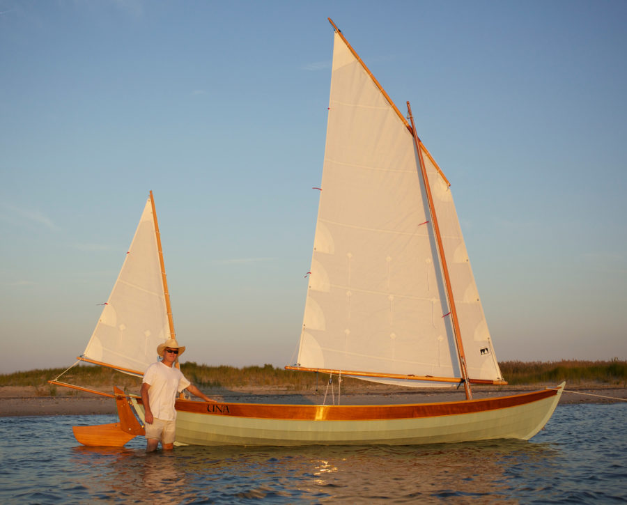
The Navlite’s brightness was quite good 100 yards down our dark driveway. I lashed the red lamp to a telephone pole on a straight country road, drove away about ¾ mile, and could still make out its glow. I took the Navlite and Tektite’s white Mark III 1-LED Chemical Lightstick Alternative along on a short cruise in my newly built 20′ open sailboat, UNA. When the sun set on our first day of sailing we were 2.5 hours from our anchorage. I tied the white light from the mizzen boom. I took the red and green lights out of the fabric housing and with 1″ webbing passed through the lights’ loops and secured them forward under the gunwales. The lights shone steadily and glistened across the water. After dusk, a tug pushing upriver was headed our way. I hailed him on the VHF and learned that he could make out our lights at a distance of 1.25 nautical miles. The wind died with the daylight and the oars came out. It was a comfort knowing that with my back turned to the bow these lights showed my presence. At anchor for the night I put the white light aloft on the main halyard. The light was still strong at daybreak.
Eddie Breeden grew up racing Moths and Lasers and has a bit of offshore sailing— Bermuda and Block Island—to his credit. A native Virginian, he’s an architect, married with 4 children. As an amateur boatbuilder he has built a Sooty Tern, an Eastport Pram, a cedar-strip kayak and a couple of skin-on-frame kayaks, all described on his blog, Lingering Lunacy . His yawl, UNA, is the subject of the Reader Built Boat in this issue.
The Navlite, retailing for $59.95 and the Mark III 1-LED, for $19.95, are manufactured by Tektite .
Is there a product that might be useful for boatbuilding, cruising or shore-side camping that you’d like us to review? Please email your suggestions.
Share this article
Join The Conversation
We welcome your comments about this article. If you’d like to include a photo or a video with your comment, please email the file or link.
Stay On Course
More From This Issue

Boat Profile
BUNDUKI is a sport boat built to Australian John Georgalas’s Deep V 16′design. Initially, the design was to be a one-off for an American friend, but the drawings have since…

Bevin’s Skiff
Joe Youcha wants to build boats. A lot of boats. Not only does he want to build boats, but he wants you to build one as well. Back in the…

Rowing the Columbia
At Cathedral Park in Portland, Oregon, the Willamette River was flowing gently, leaving barely discernible eddies around submerged pilings a few yards from the beach. Skamakowa was 75 miles downstream,…

A Hose for a Bilge Pump
The manual bilge pump that I use for my kayak isn’t very useful aboard my other boats. Without a hose it can’t get the water from the centerline some 3′…

A Folding Fireplace
By the time I graduated from high school I had studied Latin for five years. There wasn’t much call for it as a spoken language, but I was fascinated by…

On the water, you may know who, what, and where you are, but after dusk, that may not be apparent to other boaters. Illuminating your presence becomes not only prudent,…
Reader Built Boats
UNA is a double-ended yawl built by Eddie Breeden in his garage in Midlothian, Virginia. The project took him 10 months, and after he launched UNA in mid-July this year…
More Product Reviews

Stay Afloat Leak Plug and Sealant
"A leaky boat never sinks,” or at least that is what my father led me to believe when he kept a 27′ carvel-planked sloop at my hometown’s marina. If you…
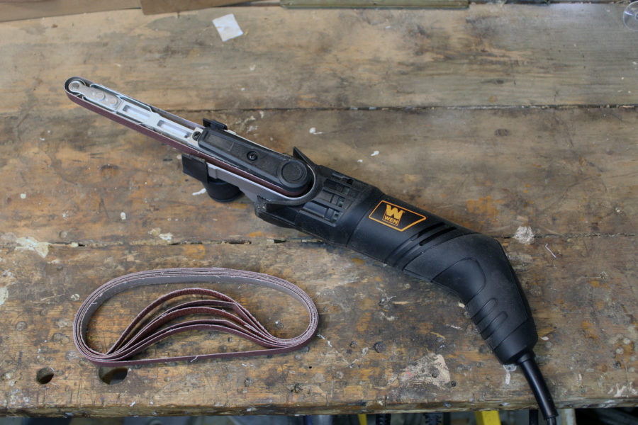
Wen Band File
Just behind the front roller there are two base plates, one on top, one on the bottom, that make contact with the sanding belt and back it up for working…

Poseidon Sliding Seats
I have been competing in open-water rowing with a traditional boat and a fixed seat for over 20 years, and several years ago I had the opportunity to row and…
Greenfield’s Sky Winch
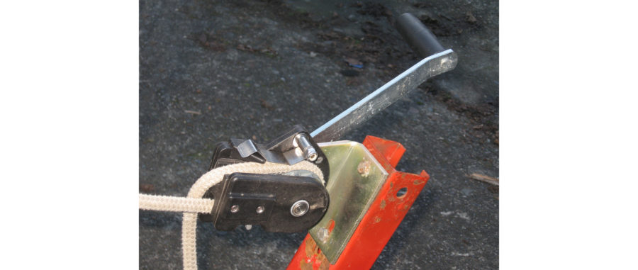
There’s a little balancing act I have to do when hauling my boat up on its trailer. After I draw the boat in by its painter, I tiptoe down the…
Subscribe Today!
Become a subscriber today and you’ll recieve a new issue every month plus unlimited access to our full archive of backlogged issues.
Already a subscriber? Sign In
Subscribe For Full Access
Flipbooks are available to paid subscribers only. Subscribe now or log in for access.
Boat Navigation Lights Rules: Illustrated Beginners Guide
When navigating at night, the lights on other boats are your first clue about the moving dangers around you. And your navigation lights are your first line of safety in avoiding collisions in the dark, and they tell others vessels what you are and what you are doing. The rules sound complex, but with a little understanding you can get the basics for any situation.
So what are the basic navigation light rules? For most small vessels, motoring requires red and green (port and starboard) lights, and a white light visible in all directions around the boat. This is almost always a stern light and a masthead light on sailboats. Boats under sail require port and starboard lights, and a white stern light. Sailboats below sixty-five feet may show a tricolor light at the masthead instead of side and stern lights when sailing.
That's it, in a nutshell. There's a little more to it, as the rules change with different sizes and there are some specifics about angles of display for the colors. Identifying other ships at sea requires more study, but the basics are the same. And it's not much trouble to make sure you've always got the proper lights on your vessel.

On this page:
What are the official colregs rules for your sailboat, what about the uscg (united states coast guard) rules, lighting at anchor, identifying the boats around you.
The International Regulations for the Prevention of Collision at Sea , abbreviated "COLREGS" is very specific about the lights required, their shapes and sizes, and the distance they must be visible. For the smaller boat, the following definitions apply.
- Masthead Light - a white light placed centerline on the boat showing an arc of 225 degrees with 112.5 degrees either side of the front of the vessel.
- Sidelights - A red light on the port side and a green light on the starboard. They must show an arc of 112.5 degrees from centerline of the bow.
- Stern light - A white light on the stern of the boat showing an unbroken arc of 135 degrees from centerline of the vessel.
- All-round light - A light showing in an unbroken arc of 360 degrees.
The good news is you need not measure these angles. Any properly installed USCG or COLREGS approved light which will cover the correct arcs. If you have to replace the original light from your boat, make sure it's with an approved replacement.
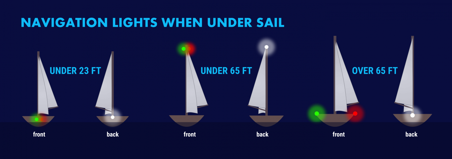
Lights When Sailing
The specific rules for a sailboat under sail are in COLREGS Rule 25 and vary slightly with the size of the boat. A sailboat powering is considered a power boat and falls under in Rule 23.
- Under 23 feet (7 meters) - side lights and a stern light, possible. If these lights can not be displayed a light must be kept at hand to help avoid a collision. This can be a bright flashlight.
- Over 23 feet - Side lights visible to one nautical mile and stern light visible for two.
- Vessels under 65 feet may combine both sidelights into a single lantern on the bow.
- May show a tricolor light on the masthead instead of sidelights and a stern light. It's one or the other though, do not show these lights at the same time .
- Masthead light must be visible for three nautical miles, all other lights must have a two nautical mile visibility.
- Side lights must be separated.
- May not show a masthead tricolor light.
- Masthead light must have five nautical mile visibility, all other lights must be visible for two nautical miles.
- Optional masthead lights - any vessel under sail may display a red light over a green light at the masthead with sidelights and stern light. The red over green may NOT be displayed with a masthead tricolor light. It's one set or the other.
Lights When Motoring
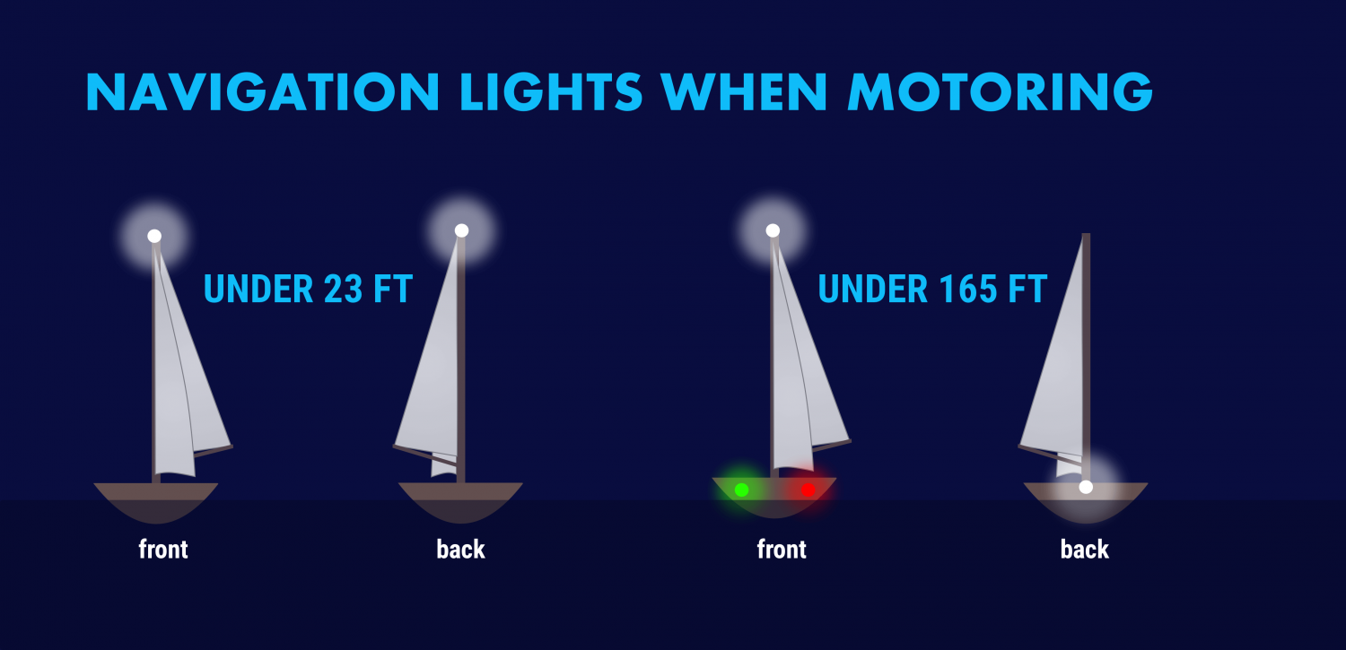
For all navigational purposes a sailboat under power is considered a power boat. This includes motor sailing - if the engine is on and providing propulsion you are on a power boat, even if the sails are up . This applies to navigation lighting, sound signals in fog and limited visibility, and rights of way.
Sailboats under 50 meters under power need to show:
- A masthead light
- Stern light
A power-driven vessel under 23 feet (7 meters) that does not exceed seven knots of speed may display an all around white light, though sidelights should be used if available.

The USCG has published its own "Rules of the Road" that are based on the COLREGS. In addition, it has rules for the "Inland Waterways" for rivers, inland lakes and the Great Lakes.
The good news is this has no impact on what you have to do with your own boat.
They mostly relate to lighting changes on towed vessels like barges and tugs. For example, a vessel towing or pushing another vessel in the ocean under COLREGS shows two masthead lights, sidelights and a stern light, whereas in Inland Waterways the towing or pushing vessel displays two yellow towing lights instead of a white stern light.
If you sail on lakes, rivers or the Great Lakes where towed commercial traffic is common you should learn the inland lights, but coastal or ocean sailors will never see these.
When you anchor outside a designated mooring field, you should display an all around white light at the masthead or as high in the boat as practical.
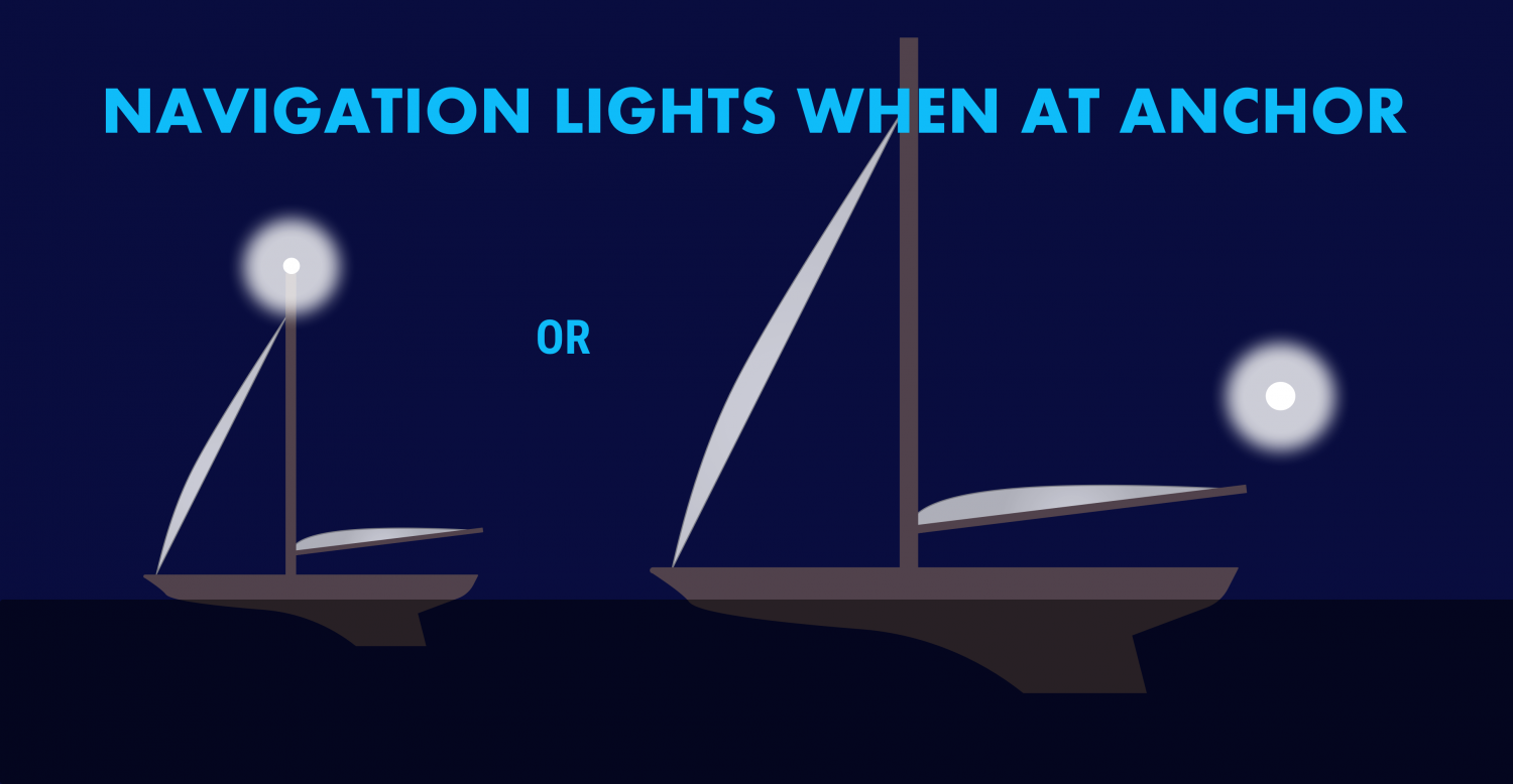
If your boat is large and has a very tall mast, you may wish to display another light closer to the waterline. Boats approaching in the dark may not see a light on a mast sixty or seventy feet in the air when they are close to your boat.
We use a simple garden path light on our stern when we anchor, left in a rod holder or flag socket. It comes on automatically at dusk and is a cheap and easy way to be more visible. There is no specific rule stating you can not display more lights than required, or the nature of any lights beyond the required all around light.
The COLREGS also specify that a round black "daymark" should be displayed in the rigging of any vessel at anchor. Very few small vessels observe this, however it is the correct display for a vessel in an anchorage.
If you tie to a mooring in a marked mooring area you are not required to display anchor lights, but there is no harm in doing so.
The other important reason to know your lights is to figure out what's going on around you at night. The water may be ablaze with white, red, green and other lights at night and they are your first key to avoiding collisions and problems.
All combinations of lights for fishing boats, commercial vessels, and so on are outside this post‘s scope. The odds are small you will encounter a submarine, seaplane or hovercraft at night, but there are regulations regarding specific lighting for each of those vessels!
There are a few fundamentals to help you figure out what that is you see on the horizon, which way it is going, and whether it is a danger to you.
Port Wine is Red
The fundamental rule is that red sidelights will ALWAYS be on the port side of a vessel, and green lights will always be on starboard. However, some vessels can use all around red and green lights for other purposes, though those will be higher than sidelights.

The light‘s on a ship is not important, some large tankers and freighters will have their sidelights far aft and put them on the superstructure for better visibility. It is not safe to assume that sidelights you can see are on the bow of large vessels .
When you can see the color, you know which way the bow is pointing. If it's red, it's pointing more or less to the left and will travel in that direction. A green light shows it is heading more or less to your right.
If you can see the red and green lights at the same time, you are looking directly at the bow of the vessel. When you are far away, this isn‘t as alarming as if you are close crossing. Seeing red and green lights together on a vessel is something you never want to see for long.
Be aware of red and green lights used in combination with other red, green and white lights. These may not be running lights and could have other significance.
Tankers, Freighters and Large Ships
Tankers, freighters and large ships will have side lights, a stern light and a masthead light. In addition, on vessels over 50 meters there will be a second masthead light further aft and higher than the forward light. The masthead light positions are a better tipoff to the bow direction and how far from the bow the sidelights might be. Remember - on a large vessel the sidelights may not be at the bow or even close to it.
USCG Inland Rules allow for a second all-around white light on large vessels on the Great Lakes instead of a second masthead light.
Fishing Boats
Fishing boats engaged in fishing will have more complex light displays. When they aren't fishing, they will show lights like any power vessel, but Rule 26 spells out light combinations that vary by the fishing activity being done. In general:
- Boats which are Trawling but not making headway will display a green all-around light over a white all-around light , and a masthead light aft of these lights. Boats making headway while trawling will show these lights, plus sidelights and a stern light.
- A vessel fishing other than trawling will show a red all-around light over a white all-around light . When making way they will also show sidelights and a stern light.
- If a vessel has gear more than 150 meters away from the boat, it will show a second all around light in the direction of the gear. The best rule is to give fishing boats as wide a berth as you can at night. They're easy to pick out if you check the top light configurations but their course may be difficult to predict.
Towing and Pushing
Towed vessels can be the most dangerous to cross, but they have the most lights to tell you what is happening. Refer to COLREGS or the USCG Rules of the Road Rule 24 for all combinations You can pick a tow/push vessel out with the following lights:
- Two or three masthead lights in a vertical line. Three masthead lights shows a tow over 200 meters. Additional masthead lights may show for larger tow vessels.
- A towing light (yellow light with the same characteristics as a stern light) directly above the stern light.
- The will also have side lights and a stern light.
- The towed vessel will show sidelights and a stern light. Lighting may vary under USCG inland rules, where towing lights may replace stern lights. Learn these differences if this is your regular cruising ground. If you think there is a tow ahead of you, always go well behind the aft most set of lights. Never go between a tow and avoid crossing ahead if possible as it may restrict their maneuverability.
Special Situations
There are several rare situations you may encounter. As a general rule, if there are a lot of lights and you don't understand them look for the sidelights on a moving vessel. If you can find them and figure out the direction it is moving, it makes the vessel easier to avoid. Stay well clear of lights you do not understand if you can avoid them without risk.
Most of these signals are used by larger, commercial vessels and you will not need them.
They use these light combinations with other light combinations. For example a towing vessel may also be restricted in maneuverability, and a vessel constrained by draft will show running lights if moving.
- Not Under Command - two all around red lights in a single line
- Restricted in Ability to Maneuver - red, white then red in a single line
- Constrained by draft - three all around red lights

Leave a comment
You may also like, 17 sailboat types explained: how to recognize them.
Ever wondered what type of sailboat you're looking at? Identifying sailboats isn't hard, you just have to know what to look for. In this article, I'll help you.

The Ultimate Guide to Sail Types and Rigs (with Pictures)
Own your first boat within a year on any budget.
A sailboat doesn't have to be expensive if you know what you're doing. If you want to learn how to make your sailing dream reality within a year, leave your email and I'll send you free updates . I don't like spam - I will only send helpful content.
Ready to Own Your First Boat?
Just tell us the best email address to send your tips to:
Marine GPS For Boats: Understanding the Basics

GPS, or Global Positioning Systems, are satellite-based navigation systems developed by the U.S. Department of Defense for military purposes—but they're familiar to most of us as the navigational system used by our phones and cars. Whether you’re talking about the GPS on your phone, in your car, or a marine GPS for boats , all these units receive radio signals from multiple orbiting satellites to determine your position.

There are currently 30 active GPS satellites in orbit, plus some extras reserved as spares in case one or more satellites has mechanical difficulties or is damaged. By knowing the position of a minimum of three of these satellites, and calculating the time differences between the transmitted signals—which are moving through space at over 186,000 MPH—your GPS receiver can determine its exact position anywhere on earth.
Interested in Buying a Boat? Explore our Boat Finder
How to Use Marine GPS for Boating
The more satellite signals your GPS receives, the more accurately it can calculate that position, and while accuracy depends on a number of factors ranging from atmospheric conditions to receiver quality, when many multiple satellites are in view a common GPS receiver can typically put your position within a 16-foot radius. High-end receivers with dual channels can get significantly more accurate.
- Once underway, your GPS continually updates your position and provides speed and directional information.
- GPS also allows you to save positions, which we commonly call “waypoints.” For boaters, this can be helpful to permanently record the location of a channel, a shoal, or a fishing hot-spot.
- You can also string a number of waypoints together to create a route, taking you from point “A” to point “Z”.
Originally boating GPS units displayed your position in latitude and longitude, and while that information can still be displayed, on most modern marine GPS people use a digital chart to see where they are—much like you can look at a street map showing your position on your cell phone. A GPS that can display charts is called a “chartplotter” or “GPS/chartplotter.” And in recent years digital charts have become much more comprehensive in the areas they cover, have improved detail levels, and better accuracy. In fact, many modern chartplotters also allow you to improve the digital charts you look at in real-time as you operate your boat, by matching up your GPS position with depth soundings taken by your fishfinder.
Marine Navigation with GPS
Navigating with GPS is usually the most efficient, easiest way to navigate a boat, but far too many people use it as a graphical representation rather than a numeric one. You can display a digital chart on your GPS unit, and steer the boat in such a way that the boat icon at the center of the screen points in the correct general direction. But you’ll steer much more accurately if you instead use a dedicated “steering screen” that gives you the numeric compass heading you want to follow, the course you’re actually steering, and an arrow or indicator that tells you whether to steer to port or starboard to get back on the most direct course.
Be sure to read Marine Navigation: How to Navigate a Boat to get a more complete picture of navigating boats both with and without GPS. And remember: while most of us do depend on GPS to navigate our boats most of the time, no one should ever rely on it 100-percent. Like any electronic system GPS is subject to failure and you’ll need to know how to get back home when your electronics let you down.
Learn More: Marine Navigation: How to Navigate a Boat

Why You Need GPS on Your Boat
Even boaters who never leave sight of land should have a GPS/chartplotter aboard, on just about any boat. You never know when you’ll encounter fog, or a mechanical issue forces you to stay out late and navigate home in the darkness. And at times like those, you’ll be quite relieved you have GPS aboard. Plus, today’s units are so inexpensive (you can get a basic GPS/chartplotter for just a couple hundred dollars) that there’s really no excuse not to have one.
Wait a minute—your phone already has GPS, so why get another one just for your boat? That’s a good question, particularly because you can use a number of boating apps to more or less turn your phone into a mini-chartplotter. Cell phones, however, have a number of drawbacks:
- They aren’t always hearty enough to escape damage when spray starts flying or they fall off the dash and onto a fiberglass deck;
- They aren’t hard-mounted at the helm and few add-on mounts can take the vibration and impacts a running boat dishes out;
- Their batteries may run out faster than expected; and many boaters travel outside of cell coverage areas on a regular basis.
So while having a cell phone with a navigational app loaded up can come in handy and is a good back-up to have aboard, it should never be depended upon as your main navigational tool.
Other Uses for GPS on Boats
Anchor Alarm
A feature of GPS that’s useful to boaters in particular is the ability to set an “anchor alarm.” You can establish a geofence around your boat while it’s at anchor, and if the anchor drags or the line comes loose and your boat goes through the geofence, your GPS will sound an alarm.

Security System
Some of today’s systems also allow you to interface with your boat’s GPS from afar, via an app on your cell phone, so it acts as a security system. You can set that geofence up around your boat, and if someone tries to steal it, you’ll get a text alarm as soon as it moves out of position.
Additional Features
If your GPS is “networked” (wired to the other electronics aboard the boat) it can also fulfill a number of additional functions.
- It can let the autopilot know where to steer, overlay additional data (like boat radar ) over the digital charts.
- Perhaps most importantly, give your VHF radio the boat’s position data. When your VHF receives position data you can use it for DSC (digital selective calling). Do so, and if you ever have to call the Coast Guard they will receive your exact position data via the radio transmission. This is a potentially life-saving feature, so be sure to take a closer look at VHF communications and DSC by reading How to Use a VHF Radio .
To learn more about GPS and see the government’s official statements about it, read FAQs, and more, visit the official U.S. Government GPS website .
Read Next: 5 Best Marine Navigation Apps for Boaters
You Might Also Like:
- 10 Best Boating Apps: Navigation, Fishing, Weather & More
- How to Use a VHF Radio
- How to Tie Up a Boat: Mooring Guide
- Weather Safety Tips for Boaters
- Find the Right Boat for Your Lifestyle
Join Our Newsletter!
Get community news, buying bargains, and how-to guides at your fingertips.
- Pontoon Boats
- Personal Watercraft
- nauticalknowhow
- Nautical Knots
- Tools and Calculators
Ranking The Best Boat GPS On The Market

Garmin Striker 4

Humminbird Helix 5 G2

Garmin Echomap Plus 94sv

A Marine GPS is an indispensable piece of equipment for the modern boat owner. Working out where you are on the land is hard enough, but it’s a far more difficult task when you’re out on open water. Historically, sailors would have to rely on their years of navigational experience, understanding complex sea charts and determining their position and heading by using the positions of the sun and stars. Luckily, modern technology has evolved to make marine navigation far easier than ever before.
The modern devices rely on GPS (Global Positioning System) technology. GPS works with satellites to pinpoint a location on Earth with incredible accuracy. It’s excellent for plotting routes, determining directions, avoiding other naval traffic, and alerting emergency services in the event of an accident. Traveling the seas without one is a dangerous game.
But there are so many different kinds of boat GPS speedometer, tracker, fish finder, and chartplotter devices out there. They can be dashboard mounted systems, or portable handheld marine GPS products. But which one is the right one for you?
We’ve put a list together of the best marine GPS devices out there to make your shopping trip a little easier.
The Garmin Striker 4 is the ultimate fish finding device. It’s a small and compact GPS that features a 3.5 inch color display, which allows you to find fish, mark positions, and navigate when you’re out on open water.
Fishing enthusiasts will love this boat GPS because it relays in-depth information about what’s going under the waves. Using a CHIRP sonar transducer that uses a continuous sweep of frequencies to map the deep and search for fish, the Striker 4 offers detailed information about fishing targets and potential fishing grounds.
You can place a waypoint market on your favorite fishing grounds using the GPS systems to allow you to find your way back on your next trip with ease. The advanced, high-sensitivity GPS system shows your exact position, direction, and heading, in relation to map points and markers, making for simple and easy marine navigation.
The device also logs your sonar history, operates as a GPS boat speedometer, calculates distance, depth, journey times, and water temperatures.
The Garmin Strike 4 features an easy to use keyed interface with simple buttons, a tilt and swivel mount, and a number of other cool mounting features. It does require a 12-volt battery, or special aquatic battery systems though—so keep that in mind.
- Buy on Amazon →
- Buy on Bass Pro →
- Buy on Walmart →
Simple keypad operation
Advanced underwater imagery
High-sensitivity GPS system
Compatible with other Garmin maps
Humminbird is one of the most popular fish finding and mapping device makes in the United States. If you’re looking for a GPS-enabled marine system that can help you track down the best fishing spots and keep you on course at all times, then this could be the device for you. Ideal for both freshwater and saltwater pursuits, the Humminbird Helix 5 G2 has got your next voyage mapped out.
Suitable for pontoon fishing boats, SUPs, kayaks, right up to full-size ocean-going vessels, the Humminbird Helix 5 G2 has everything you need for a safe journey. Pre-loaded with maps and data from both LakeMaster and NOAA, the Helix 5 G2 is fully-capable of navigating you to your journey, noting buoys, hazards, markers, marinas, harbors, and other essential way points.
The actual GPS system uses WAAS technology to give astounding global positioning fixes, with an accuracy of within 2.5 meters. It also features a very accurate chart plotting tool, with using a built-in cartography tool from Anima.
If that wasn’t enough, the Helix 5 G2 is a competent fish finder. It uses CHIRP digital sonar and imagine sonar to map the lake or ocean floor, using live charts and down imaging to locate fish or potential fishing areas. All that data is produced onscreen in high-definition via the device’s 5-Inch color WVGA display.
MicroSD functionality for adding more maps
Mounting hardware and power cable are included
Simple keypad control interface
Amazing Side & Down imaging
Lowrance HOOK2 Fish Finder & GPS

Lowrance is another name that you can trust when it comes to marine electronics. This particular model is a fish finder, chart plotter, and GPS all in one. It’s reasonably priced, has an easy to use interface, and it has a handy 5 inch screen too.
The fish finder relies on an auto-tuning sonar, that uses CHIRP sonar with an extra-wide cone angle that increases underwater visibility, giving you more coverage than other products on the market. It’s easy to control via the smartphone-like interface, allowing you to keep your mind focused more on fishing than fiddling with menus.
The HOOK2’s GPS capabilities are quite advanced too. Thanks to the internal antenna, the HOOK2 enjoys a very accurate level of precision. It will easily find your location, and point you in the direction of your favorite fishing grounds, local marinas, and other key landmarks or waypoints.
You get quite a lot of cool things included in this package too. It comes with a tough quick-release tilt and swivel mounting bracket, an SD card slot for loading additional content, and C-MAPS US Inland Lake Maps installed as standard. These maps feature contoured charts for 3,000 lakes, as well as regular charts for a further 9,000 lakes.
Unlike some other products on this list, Lowrance has given the HOOK2 a one-year warranty covering parts and labor, which is a testament to the brand’s confidence in their products. This is one of the best marine GPS systems for lake fishermen.
Fish finder, chart plotter, GPS, all-in-one unit
Pre-loaded with US inland lake maps
Split-Shot transducer for detailed underwater imagery
One year manufacturer’s warranty
At the more premium end of the budget spectrum, we have the Garmin Echomap Plus 94sv. It’s an advanced GPS system with a useful 9-inch display and advanced fish finding technology. It’s pre-loaded with Bluechart G3 coastal charts, and Great Lake charts too, so it’s ideal for both saltwater and freshwater explorers.
The fish finder operates using a GT51-TM 12-pin transom mount transducer, that delivers CHIRP sonar, provides depth and temperature readings, and offers crystal clear imaging sent directly to the screen. With Quickdraw Contours, this Garmin boat GPS can create personalized fishing maps while you’re steering across the surface.
Thanks to built-in wi-fi technology, the Garmin Echomap Plus 94sv can seamlessly sync with your smartphone, allowing you to take calls, send text messages, and send emails directly from the GPS screen. It also allows for real-time updates to be added to your maps and charts, allowing you to plot courses accordingly, avoiding bad weather or other markers and waypoints.
What’s more, this Garmin GPS system is also compatible with a wide range of other Garmin products, and it can actually work in partnership with NMEA 2000 technology. This means that it’s possible to link your GPS to read engine data, external sensors, autopilot systems, and more.
Thanks to the simple screen and key-assisted interface, this Garmin GPS marine must-have is an essential piece of equipment for any coastal fisherman who enjoys exploring.
QuickDraw Contours live mapping
Wi-fi enabled interface for inter-connectivity
Bluechart G3 Coastal and Great Lake charts included
Fully compatible with other Garmin products
Cobra COB-MR

The Cobra COB-MR is a practical handheld marine GPS receiver with all of the necessary functions for boating enthusiasts, at an affordable price. If you regularly take your boat off-shore, then having something like this on board is an essential.
Cobra’s COB-MR device is a small and compact receiver that comes equipped with a VHF radio, access to NOAA weather channels with 24-hour weather updates, a built in GPS receiver, and a very useful Digital Selective Calling function, with a Distress Button.
While it’s not as advanced as many other products on the market, with fancy mapping or fish finding abilities, it can easily pinpoint your location, relay life saving information, and keep you on course.
It’s also Bluetooth enabled, waterproof, and designed to float. What’s more, it’s battery powered and will continue to function in emergencies, where hardwired equivalents would fail if there’s power loss.
To make the most of this marine GPS system, take the time to fully register your product and set it up using the manual.
For the price, it’s very hard to find fault with this cool GPS device. Sure, there are others out there but this one is ideal for budget-focused mariners, or as a backup for when other devices fail.
- Buy on Cobra →
Instant access to Channel 9 & Channel 16 in emergencies
Submersible to IPX8 (JIS8) standards
Access to weather information at all times
3 selectable power settings
Ray Marine Dragonfly Pro 7

Next, we have this exceptional marine GPS and fish finding combo from Ray Marine. It’s not the most advanced GPS system in the world, but it can be used in partnership with a number of marine GPS apps, which makes it an invaluable tool for boaters.
The most impressive feature of the Dragonfly Pro is the fish finding sonar and Down Vision technology. It uses a dual channel CHIRP sonar to accurately map the sea floor to depths of up to 180 meters. The data received is model into quality maps that are then displayed on the Dragonfly Pro’s 7 inch LCD display.
The actual GPS side of this marine GPS unit features wi-fi enabled real-time up-to-date charts that keeps you on course and where you want to be. Bathymetric charts work with Ray Marine’s Navionics marine GPS apps to give you the latest navigation information. It can be used as a chartplotter, can record your journey, and drop waypoints and trail markers to help you find the same locations again and again.
If you’re looking for a device with a big screen and excellent clarity, with simple controls that’s easy to install, then this one is the model for you. It is quite expensive compared to some other models, but it does have a huge range of functions, making it quite a versatile bit of kit.
This particular model can be bought either with charts or without. Make sure you know which version you’re buying to avoid disappointment. “No chart” simply means that you’ll have to buy them separately and load them on manually.
Wide LCD screen
Built in wi-fi with smartphone compatibility
Live stream marine GPS chartplotter apps
Dual-channel CHIRP sonar
Standard Horizon HX870

This is another handheld, highly-portable, and battery powered GPS system. This is from Standard Horizon, a big name in the radio-communications industry. It’s a VHF radio with an internal GPS system, with emergency call functions, with emergency alert and distress call capabilities.
The Standard Horizon HX870 uses WAAS technology to provide accurate location details, which users can transpose onto a paper chart. It also has a large dot matrix display that can be used for navigation, displaying your route, heading, speed, and location. Despite the old-school display, it actually has an easy route creation and waypoint marker system, which is invaluable at sea.
One of the best features of this device is the NOAA weather channel access that provides up to the minute weather alerts and reports around the clock. There’s also access to 70 Channel Class “D” DSC (Digital Selective Calling) channels, with a noise cancelling function for clear voice clarity no matter the weather conditions.
Other features include a USB data port for easy data transfer, a full-waterproof IPX8 waterproof rating, full flotation on water, and an easy to operate key interface. It also has a quick charging function that fully restores the lithium ion battery to full-life in around 3 hours. This is an excellent budget GPS device.
Water activated strobe light for emergencies
Fully waterproof, and it floats
Excellent battery life
Emergency distress call capabilities
Garmin GPSMAP 78SC

Next, we have a mid-range product from Garmin. This is the GPSMAP 78SC, a small marine GPS chartplotter device with loads of cool features that every watersports enthusiast needs to own. Not just watersport enthusiasts either—it’s a fun product that can be used for recording speed in your car, or recording flight date. However, it’s designed for aquatic purposes, and it’s best suited to those pursuits.
This boat GPS is equipped with BlueChart g2 coastal charts as standard, but you can easily load other maps using the microSD port. The coastal maps include shoreline details, depth contours, harbors, marinas, and navaids, for the entire United States and Bahamas.
Using a 3-axis tilt-compensated electronic compass, the GPS system can give you detailed information of your location, heading, and bearing. It also features a barometric altimeter that can detect your altitude, and plot barometric readings to predict changing weather and storms.
The WAAS-enabled GPS is a highly-sensitive system that can pinpoint your location easily. It uses HotFix satellite prediction tools that can log your location even in difficult conditions.
The device also uses Garmin Connect technology. This allows you to connect to your computer and trace or plan your routes using Google Earth, and share your routes and details with others.
2.6-inch color TFT display
MicroSD compatibility to add maps
20 hour battery duration
It’s water resistant and it floats too!
The Best Boat GPS: Buying Guide
What is a marine gps.
A marine GPS is an essential marine navigation tool—but what does it actually do? As you can see from the list above, there are GPS emergency radios, fish finders, chart plotters, and more. Do all GPS devices do the same things, or do some serve different purposes?
First, let’s look at what a boat GPS actually does. It’s a global positioning system that can be used on bodies of water and over open ocean. They can pinpoint your exact location and give you your bearings. All GPS devices will at least do this.
Emergency GPS Systems
Some have emergency tools that allow you to call in help if you find yourself in distress. Others have live weather updates, live marine communication updates from other vessels, and other emergency functions. Many of these are handheld, battery-operated devices that can be used if your main power source is down.
GPS Fish Finders
Another popular kind of GPS system is a fish finder. These devices use transducer sonar to map the lake or sea bed, and track fish. The burst of scanning sonar bounces off of objects in the water, and the fish finder’s sensors convert the results into imagery that fisherman can read to determine the location of fish. These fish finders are very useful for fishing trips .
GPS Chartplotters
A GPS chartplotter or (chart plotter) is primarily a mapping and navigation tool. Like automotive satellite navigation products, these boat GPS trackers keep an eye on your location and plot your position on a map. They continuously monitor your exact position, your speed and heading, and plot your location in relation to land mass and other important markers or way points. They can also be used to store routes that can be loaded when you need them.
Important Features To Look For
Once you’ve got an idea of what type of GPS device you’re looking for, you can start focusing in on what other important features that you need. Here are some things to consider when you’re searching for a GPS system for your boat.
Maps are arguably one of the most important features of any GPS unit. However, not all marine GPS navigator devices come with maps installed. Some require your charts to be bought separately and uploaded to the device, while others have them pre-installed. There are some devices that don’t have any maps at all, simply relaying your co-ordinates which you can then note on a good old-fashioned sea chart instead.
Even if a device is pre-loaded with maps, make sure to check what areas they cover and what kind of water. Not all devices will have freshwater charts. Most will only have charts for your country.
Chart plotters and fish finders are great, but emergency tools are some of the most useful to have installed on your GPS marine navigation devices. Emergency calling and distress signaling is incredibly useful, particularly if you’re heading out to sea. Even if you’re staying close to the shore, accidents can happen, and having a device that can for help is a wise idea.
It’s easy to prioritize chart plotting as an essential feature, and it is an important feature, but safety should be just as important too. Some GPS systems have wi-fi that link up with marine GPS app programs that can be set up for emergencies.
Other cool features include an electric compass, a barometer, and weather updates. Keep an eye out for these when you’re shopping.
Portability
Do you need a battery-operated handheld device, or would you prefer a hard-wired, permanent interface? If you use multiple small-size vessels, it might be more economical to buy something portable that you can use on different boats from one day to the next. These devices usually don’t offer the same kind of features that more permanent-mounted devices do. However, if you primarily use one boat, it might be best to invest in a permanent GPS system. It all depends on your needs.
If you opt for a handheld marine GPS navigator, then you should be mindful of the battery life. Some have standby times of over 20 hours, while others have quite limited 3-hour operational times. Naturally, what battery life you need depends on how long you’re on the water.
Some devices rely on your boat’s battery and motor to operate. These devices are more reliable but they do have some quirks to them. Always make sure that you read the voltage and motor type required to power one of these. Some trolling motors aren’t up to it, while bigger batteries can be overkill.
Even if you have a system that’s hooked up to your boat’s motor, it’s always wise to carry a battery-operated back-up, just in case of power failure.
A marine GPS unit should be waterproof. That should go without saying. However, there are different kinds of “waterproof” definitions. Here’s the official scale of waterproofing , and what level of protection each designation offers:
Another key feature to keep in mind is the user interface. Touchscreen devices usually feature nice wide screens with crystal clear displays. They can display a lot of useful information all at once. Unfortunately, touch screen technology can be tricky to operate in wet conditions.
Keypad controlled devices are simple to use and work well in wet conditions. Unfortunately, the actual control systems can be a pain to use, with laborious menus. More often than not, these keypad devices have smaller screens too.
The difference in price between the two types could help make that decision for you though.
The price is arguably the most important factor to take into consideration when buying a marine GPS tool. Good quality equipment doesn’t have to be expensive, but you should be wary of a product’s limitations. If you go cheap, don’t expect it to have all of the top features that you’d hope for. It will be basic, but it should do the trick.
It’s also important that you don’t fall for the whole “it’s the most expensive so it should be the best” trick. Throwing money at a device isn’t the right way to go. It’s wise to make sure that you’re investing in a product that you actually want, will actually use, and suits your needs. There’s no point spending thousands on an ocean-ready GPS that’s designed for transatlantic journeys when you’re only fishing around your local lake in a pontoon boat.
Lastly, always read the reviews. Don’t just take the word of marine GPS review sites. Make sure you check with other sources, writers, journalists, and forums before hitting the buy button. Also, if you’re buying from an e-commerce site like Amazon, then read the FAQs and reviews there too.
A certain product may ship without maps loaded into it, or with charts that don’t cover your area. The review section is the best place to mine for answers to those smaller, and often-overlooked questions.
The Best Boat GPS: In Summary
For sailors looking for a budget GPS option, or for those looking for an excellent backup system, then we recommend the Cobra COB-MR. It can easily calculate your position, runs off of battery power, and has an emergency alert system. It’s not the most advanced system, since it doesn’t boast any live charts, fancy imagery, or fish finding technology, but it is cheap, easy to operate, and very practical.
If you have a bigger budget, then the most impressive premium product on the market would have to be the Garmin Echomap Plus 94sv. A Gamin marine GPS won’t let you down. Ever! It’s an advanced fish finding tool with sonar technology, contouring imagery, and more. It also features a highly-sensitive GPS system, with detailed maps and amazing connectivity. Since it’s compatible with other Garmin products, it’s a very useful tool to have in your satellite-navigation arsenal.
For boaters who are just looking for a decent product that ticks all of the right boxes, won’t break the bank, and won’t fall apart easily, then we’d recommend the Humminbird Helix 5 G2. Primarily developed as a fish finder, the Helix 5 does everything a fish finder can, but it also has an advanced GPS system with an easy to use chart plotting tool. It scores big in terms of value for money, and that’s why we’ve named it as our favorite over all.
Joe Appleton is an outdoor enthusiast who loves everything from bushcraft and hiking to wild camping and boating. If he’s not out in the woods, you’ll find him out on the water.
Categories : Boats , Fishing , Kayak , Reviews

Spencer Meyers on July 11, 2020
Thanks for the excellent reviews! It can be hard to narrow down the product you are looking for. Too many times have I been in a hurry and purchased the first product that seemed to fit what I wanted. These Boat GPS systems seem to be more tailored to fishing. Are there different Security systems based on boat size or are they all in 1? Would a yacht require different boat security than a smaller fishing boat or does it come down to features? Thanks again!

Mark & Alpha Remaley on January 18, 2021
With so many choices I am confused. Our pontoon boat is in a relatively small (less than 1 aq. mi.) inland lake and I would like a really good depth profiler so I can see details on the bottom (for scuba-diving & curiosity), and a fish-finder. Those are the two things I really care about, and navigation in a small land-locked lake isn’t really a major concern, so in your opinion what unit would be the best for the limited conditions I have outlined? Thanks for any help on this.
Leave a Reply Cancel reply
Your email address will not be published. Required fields are marked *
Save my name, email, and website in this browser for the next time I comment.
More in Boats
What Is A Gunwale?

131 of the Best Hawaiian Boat Names
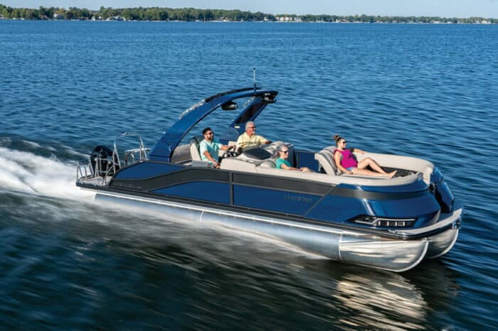
167 Patriotic Boat Names
The 138 Best Boat Names for Dog Lovers

The People’s Poncho Review and Ratings
Oru Lake Kayak Review
About Boatsafe
Established in 1998, BoatSafe is your independent guide into the world of boating, fishing, and watersports. We provide expert insights and detailed guides to help you find products tailored to your needs and budget.
Contact Boatsafe
- Address: 4021 West Walnut Street. Rogers, AR 72756
- Phone: (479)339-4795
- Email: [email protected]
Site Navigation
- How We Test
- Corrections Policy
- Privacy Policy
- Terms & Conditions
- Editorial Policy
- Affiliate Disclosure
Our Reviews

All content is © Copyright 2024. All rights reserved.

6 Best Marine Navigation & GPS Apps for Boaters (Free & Paid)
Table of Contents
For almost everything you do today, there’s an app that will support, enhance or complement that activity. Recreational boating is no exception, and there are dozens of boating apps to help you enjoy time on the water.
Arguably, marine navigation apps are some of the most common—and the most useful—available to boaters today, with a range of options to suit different needs. Some boat GPS apps, for example, utilize NOAA raster charts, which are essentially scanned paper charts incorporated into their systems. Some apps offer vector charts, providing electronic charts that allow for scrolling and zooming in for enhanced detail.
The convenience of downloading these apps to your iPhone, Android, or tablet enables you to have them readily available regardless of the boat you’re on, significantly enhancing your navigational capabilities.
Here are our top choices for boat navigation apps:
1. Navionics

A perennial favorite is Navionics because it’s easy to use and comprehensive in scope. Navionics mimics a standard chartplotter experience and in some cases can connect to an onboard plotter via WiFi. Creating waypoints and routes, measuring distances and understanding depth contours and aids to navigation is pretty straight forward with this app.
Once downloaded, the charts stay on your device and can be used offline which is great when you’re cruising in areas with little coverage. Bonus functionality includes weather and tide information and dock-to-dock routing that helps you set a viable course based on your vessel’s parameters like draft.
- Price: Two-week free trial, then subscriptions starting at $14.99
- Click here to learn more and download.

Easy to confuse with Navionics (especially when downloading the app), iNavX is a whole different animal. There’s a $5 charge to download the app, and then you can download NOAA raster charts for free and vector charts (powered by Navionics and C-MAP) for a fee.
Beyond navigation, details on marinas, fuel docks and other facilities are also available. Weather data overlays and additional features like engine data and AIS collision avoidance information can also be viewed, but the app can get technical in a hurry and may take longer to learn.
- Price: $4.99, plus an annual subscription

C-MAP is the primary other choice besides Navionics for the underlying charting information that many apps use with their own user interface. The new C-MAP Embark was designed to be intuitive so after a few minutes, you won’t really be looking for the manual to manage the basics like waypoints, routes and nav aids.
A funky feature includes the app changing color based on your environment, so the charts are always easy to read regardless of the surrounding light. The basics include a free download, but chart additions and weather data will be in-app purchases.
- Price: Free, with available in-app purchases
4. SeaPilot

SeaPilot sets an ambitious agenda for itself: it’s a basic navigation app (which has a free three-day trial) but it ramps up from there. You’ll need to upgrade to the premium version so you can add various chart areas, weather forecasting and routing capabilities. Beyond that, you can connect to Facebook to find nearby boating friends.
For sailors, there’s a database of polar diagrams which are graphs of the theoretical top speeds attainable by over 300 kinds of sailboats.
- Price: Three-day free trial, then starting at $7.99
5. i Sail GPS:NOAA USA Charts

For barebones basics, iSail is a great choice because it’s inexpensive and you can skip sign-ups and pop-ups. Measure distances to your waypoint, upload waypoints and routes and get quick ETAs to your next intermediate or final point.
iSail uses NOAA raster charts which are downloaded to the device so they can be used without Wi-Fi or out of cell range. There are few advanced features, but this app gets the job done when you need the basics. It’s for iOS only.
- Price: $7.99, with available in-app purchases
6. KnowWake

The best way to describe KnowWake is to compare it to a road-based app you’re probably already familiar with–Waze. Like Waze, KnowWake is crowd-source and will provide information on congested waterfront locations–coastal and on 350 inland waterways.
On a bustling weekend, you can see how busy marinas, restaurants, boat ramps, fuel docks, and dive and snorkel sites are. You can use it in North America, on the Great Loop and in Canada as well as in parts of the Caribbean. The app uses real-time updates and it has location-sharing between users so you can find friends.
- Price: Free!
All the boating apps above vary in price, complexity and focus, and although some are free, advanced features generally come at a price. Some take a bit of time to learn, but they’ll all put some peace-of-mind in your pocket the next time you slip the dock lines.
Bonus Apps: Boatsetter

Did you know Boatsetter has an app? Make that two! We’re proud to offer the largest peer-to-peer boat rental app that connects boat owners and boat renters, so you can get on the water without committing to boat ownership. Rent one of over 17,000 boats in 600 locations. Boatsetter isn’t the only private boat rental app , but it offers an exclusive partnership with BoatUS and Geico for insurance.
- Price: Free! (Boat owners should also check out our Boatsetter Owner’s app , perfect for stress-free boat rental management and easy communication with renters).
- Click here to download for iOS ; or click here to download for Android .
Browse Available Boat Rentals in All Locations
Zuzana Prochazka is an award-winning freelance journalist and photographer with regular contributions to more than a dozen sailing and powerboating magazines and online publications including Southern Boating, SEA, Latitudes & Attitudes and SAIL. She is SAIL magazines Charter Editor and the Executive Director of Boating Writers International. Zuzana serves as judge for SAIL’s Best Boats awards and for Europe’s Best of Boats in Berlin.
A USCG 100 Ton Master, Zuzana founded and manages a flotilla charter organization called Zescapes that takes guests adventure sailing at destinations worldwide.
Zuzana has lived in Europe, Africa and the United States and has traveled extensively in South America, the islands of the South Pacific and Mexico.
Browse by experience
Explore articles

Definitive Guide to Boat Eats

Understanding Why Your Boat May Be Waitlisted

Ten Holiday Gifts Every Boater Will Love

5 Things Football and Fishing Have In Common

Outdoor Master E-QuickHue Photochromic Goggle Lens – Fast VLT Change
Hike & Camp
Recent gear reviews.

Swany X-Change Gloves – Warm, Durable and Versatile

Neberon Pro Heated Gloves – Budget Ski Gloves With Extra Warm Fingers

Outdoor Master Falcon – Stylish Look with High Performance Zeiss Lenses

Outdoor Master Heron – Great Toric Lens Entry Level Ski Goggles

Wildhorn Roca Ski Goggles – Easy Swap Lenses and Lots of Colors
Learning center.

The Essential Role of Back Support Belt – Protect Your Lower Back while Hiking

7 Benefits of Wearing Aqua Shoes During Paddleboarding

What Color Lens is Best for Ski Goggles? How to Pick The Right Lens

How Much Does a Ski Trip Cost? Complete Cost Breakdown

How to Keep Ski Goggles from Fogging Up – 12 Helpful Tips

2024 Beginner’s Guide to Skiing – How Long Does It Take to Get Good at Skiing
- Hiking Shoes
- Hiking Boots
- Hiking Sandals
- Trail Runners
- Base layers
- Hiking Shirts
- Fleece Jackets
- Softshell Jackets
- Rain jackets
- Down Jackets
- Hiking Pants
- Hiking Shorts
- Base Layers
- Rain Jackets
- Hiking Bras
- Baby Carriers
- Cookware Sets
- Water Filters
- Water Purifiers
- Sleeping Bags
- Sleeping Pads
- Hiking Poles
- GPS Devices
- Solar Chargers
- Dive Regulators
- Dive Computers
- Dive Watches
- Dive Wetsuits
- Dive Gloves
- Dive Lights
- Dive Knives
- Spearfishing Wetsuits
- Spearfishing Masks
- Spearfishing Fins
- Spearfishing Watches
- Freediving Wetsuits
- Freediving Masks
- Freediving Fins
- Freediving Watches
- Sit On Top Kayaks
- Inflatable Kayaks
- Fishing Kayaks
- Tandem Kayaks
- Touring Kayaks
- Kayak Paddles
- Kayak Seats
- Kayak Roof Racks
- Kayak Carts
- Stand Up Paddle Boards
- Touring SUPs
- Inflatable SUPs
- Fishing SUPs
- SUPs For Yoga
- SUPs For Surfing
- SUP Paddles
- Climbing Boots
- Belay Devices
- Climbing Shoes
- Women's Climbing Shoes
- Bouldering Shoes
- Approach Shoes
- Climbing Pants
- Bouldering Pants
- Mountain Bikes for Men
- Mountain Bikes for Women
- MTB Handlebars
- Bike Saddles
- Bike Computers
- Bike Lights
- MTB Jackets
- Bike Helmets
- Bike Packing Gear
- Fat Biking Gear
- Ski Bindings
- Ski Helmets
- Ski Goggles
- Ski Jackets
- Snowboarding Bindings
- Snowboarding Boots
- Snowboard Helmets
- Snowboard Goggles
- Snowboard Pants
- Snowboard Jackets
- Snowshoe Poles
- Avalanche Beacons
- Avalanche Probes
- Avalanche Shovels
- Ski Backpacks
- Surfboards For Beginners
- Surfboards For Kids
- Surfboard For Small Waves
- Soft Top Surfboards
- Foam Surfboards
- Body Boards
- Boogie Boards
- Kiteboarding Kites
- Kitesurfing Boards
- Kiteboarding Harnesses
- Surfing Wetsuits
- Men's Rash Guards
- Women's Rash Guards
- Board Leashes
- DLSR Travel Cameras
- Mirrorles Travel Cameras
- Point and Shoot Travel Cameras
- Fuji Travel Lenses
- Nikon Travel Lenses
- Tripods for Travel
- DLSR Landscape Cameras
- Mirrorles Landscape Cameras
- Point and Shoot Landscape Cameras
- Fuji Landscape Lenses
- Nikon Landcape Lenses
- Canon Landcape Lenses
- Tripods for Landscape Photo
- Wildlife Cameras
- Wildlife Lenses
- Wildlife Tripods
- Wildlife Monopods
- Birdlife Cameras
- Birdlife Lenses
- Surfboards For Small Waves
Best Marine GPS Chartplotters for Sailing of 2024
The days when sailors navigated with compass and sextant are long gone: modern marine electronics provide us with a range of information that explorers of the past couldn’t begin to imagine. Larger vessels are outfitted with networks integrating GPS, charts, radar, sonar, wind sensors, communication, emergency alerts and much more. Nowadays, even handheld units can handle any navigational problem short of plotting a course for Margaritaville or the Fountain of Youth. All of that capacity does create some confusion, and the range of options on the market can be daunting. We’ve simplified the choices with this guide to the best marine GPS chartplotters.
We’ve tried to keep the descriptions simple, but if CHIRP, WAAS, and NMEA 2000 aren’t part of your day to day vocabulary, you may want to skip to the bottom of the article and read the explanations first!
For more of our top sailing gear recommendations, check out the Best Solar Panels for Sailboats .
Quick Answer - The Best GPS Chartplotters for Sailing
- Garmin GPS 73 View at Amazon
- B&G Vulcan 7 View at Amazon
- Raymarine Axiom 7 View at Amazon
- Garmin GPSMap 8612XSV View at Amazon
Comparison Table - Best GPS Chartplotters for Sailing
Reviews - best sailing gps chartplotters, garmin gps 73.
- Type : Handheld
- Display : 2.6” B&W
- Sonar Transducer : Not Included
- Sailing Software : Garmin Sail Assist
- Networking : NMEA 0183, Bluetooth, USB
- Runs 18 hrs. On 2 AA Batteries
- High-Sensitivity Receiver Locks Satellites In Any Conditions
BEST HANDHELD
This one is not actually a chartplotter at all. We’re including it in the review because it has a solid array of sailing-specific features that make it a great choice for boats that are too small to host a console-mounted system or as a backup device for use if a larger vessel’s primary system fails or if you’re forced to abandon ship.
The Garmin 73 is handheld, convenient, and easy to use. It doesn’t support the whole range of features included in Garmin’s SailAssist software, but it will give you tack assistance, virtual starting and heading lines, countdown timers, and arrival times based on sailing constraints. That’s a very tidy bundle in a very small package.
Garmin has a great deal of experience with hand-held marine devices, and the GPS73 reflects this. The back-lit buttons and high-contrast display are easy to use in very bright or limited light, there’s a useful range of marine data built in, and you can store 1000 waypoints and 100 tracks for repeat navigation. Don’t expect the GPS73 to duplicate the functions of a full-sized chartplotter with an array of sensor inputs, but it does what it does well and reliably, and it is designed with wind-driven boaters in mind.
B&G Vulcan 7
- Type : Console Mounted
- Display : 7” Color
- Sailing Software : B&G SailSteer
- Networking : NMEA 2000
- Compatible With Forwardscan Sonar and B&G Autopilots
- Instrument Data Display
- Multiple Language Packs
BEST SAILING-SPECIFIC VALUE
B&G is the acknowledged industry leader in sailing-specific marine electronics, and was the first to bring a full range of sailing support features to a consumer-oriented electronics package. The Vulcan 7 continues this tradition, wrapping an impressive array of sailing-specific features into a compact, durable, and affordable chartplotter.
The screen is bright and versatile, displaying all of your sailing and wind information with layline and tacking options overlaid on up-to-date navigational charts. It also offers race support features that get you to the start line at speed with the right heading at the right time. The system integrates with numerous accessories, notably B&G’s highly regarded autopilot systems, to give you a level of control you’d expect from a much more expensive system.
This one is all about sailing, so don’t expect a fish finder or other features more applicable to the motorized set. If you’re looking to upgrade your sailing game without spending a fortune, though, you won’t find a better choice than the Vulcan 7.
Raymarine Axiom 7
- Sonar Transducer : Included
- Sailing Software : Lighthouse 3
- Includes Surface And Trunnion Mounting Kits
- Quad Core Processor For Blazing Speed
- Coastal Coverage For USA and Canada Plus Over 20,000 Inland Waterways
BEST VERSATILE CHARTPLOTTER WITH THE MOST COVERAGE
Raymarine makes a wide range of multifunction chartplotters, from the entry-level Axion range through the Axiom Pro and elite-level Axiom XL range. All are powered by Raymarime’s Lighthouse 3 software and offer full compatibility with Raymarine’s exceptionally large range of sensors and input devices. Raymarine also offers extensive chart coverage straight out of the box: both US and Canadian coasts along with 20,000 lakes, rivers, and other inland waterways.
The Axiom 7 may not be as “sail-specific” as the B&G Vulcan 7, but that also leaves it arguably more versatile. For example, the Axiom 7 integrates a robust fish finder capability, a useful feature if you like to mix some fishing with your sailing. It also includes the Raymarine CPT-100DVS transom-mounted sonar transducer, so if you want a minimalist package you can just add a wind sensor and go! If you want to add more, you won’t be held back: Raymarine can provide Quantum radar, CHIRP Sonar, FLIR thermal cameras, audio integration, instruments, cameras, and the Evolution autopilot. This unit provides most of the features that distinguish Raymarine’s higher-end models, at a budget friendly price point!
Garmin GPSMap 8612XSV
- Display : 12” Color
- CHIRP : Yes
- SmartMode Station Controls For One-Touch Information Access
- Superior Clarity And Sunlight Readability, Even With Polarized Sunglasses
- Preloaded US Coastal And Lake Maps
BEST HIGH PERFORMANCE CHARTPLOTTER
Garmin delivers a serious high-performance marine electronics hub with the 8612xsv. You get a full HD 12” display with wide viewing angles, great clarity, and full sunlight readability, pre-loaded with full US coastal and lake charts and offering full connectivity with a huge range of sensor inputs, including Garmin’s Panoptic LiveScope live scanning sonar, which gives one of the best underwater views on the market today.
Garmin’s SailAssist feature provides the full spectrum of sail-specific information and pre-race guidance. You’ll have true and apparent wind angle, set and drift, true and apparent wind speed, and much more at your fingertips! Pair those features with Garmin’s ActiveCaptain app and link your boat seamlessly to your mobile device. If you’re a serious sailor and you’ve decided to commit to Garmin as your electronic systems provider, the 8612xvs is a natural starting point!
THINGS TO CONSIDER WHEN BUYING A MARINE GPS CHARTPLOTTER
Let’s start with the basics. A GPS gives you coordinates, a Chartplotter gives you a visual position on a chart. All Chartplotters are GPS-based, but not all GPS units will plot charts!
Chartplotters come preloaded with a range of charts, but if you sail in exotic areas, you may need to purchase additional charts. Major manufacturers supply their sail-oriented chartplotters with sailing-specific software packages that give you access to laylines, tacking points, wind trends, estimated arrival times based on speed and routes, and much more.
Remember that your chartplotter is designed to process inputs from multiple sensors and will not be fully functional without these inputs. At a minimum this will mean a sonar transducer (included with some chartplotters) and a wind sensor, but there are dozens of other options.
Most manufacturers recommend using their own instruments with their chartplotters, so your choice involves buying into a system , not just buying a chartplotter. Be sure to look at the range of available input devices and asses any input devices you may already own before selecting a chartplotter!
IT’S A SYSTEM
You’ve probably noticed this already, but when you choose a chartplotter, you’re choosing much more than just a chartplotter. The chartplotter is a hub linking a range of sensor inputs and communication devices.
When you select a chartplotter you’re committing yourself to a range of other devices that will link to it, so before you buy, you’ll want to look closely not just at the chartplotter but also at the range of input devices you’ll be connecting to it.
Fortunately all three of the major manufacturers of chartplotters offer comprehensive ranges of input devices, so you’ll have plenty of choice no matter which unit you select! If you already own wind, sonar, or radar equipment, your choice of chartplotters is likely to be directed by compatibility with your existing equipment, so be sure to take that into consideration.
Many chartplotters are compatible with third-party instruments, but you’ll want to be sure. Your electronics are a bit like your crew: sailing is easier when they get along!
SOFTWARE MATTERS
B&G, Garmin, and Raymarine all offer software packages designed specifically for sailing. All of them offer a range of features designed for both cruising and racing, including layline plots that put a 21st-century twist on the eternal challenge of sailing efficiently to windward.
All three major software systems are updated regularly and all provide similar basic functions. Cruising World offers a detailed discussion of choosing a chartplotter , but your choice is likely to be affected by personal preferences, and for most of us any of the three are likely to serve well. Certainly any of them will be a quantum leap forward from what sailors had available even a decade ago!
West Marine offers this detailed guide to selecting networked marine electronics . Practical Boat Owner offers a field test of the three major sailing assist programs ; it’s from 2015 and does not cover the latest upgrades, but gives a solid grounding on the approaches taken by the major manufacturers.
SPECS AND FEATURES EXPLAINED
NMEA is the National Marine Electronics Association. The group brought out the NMEA 0183 protocol in 1983 and introduced NMEA 2000 in 2000. These protocols enable all of a boat’s electronics to communicate with each other in a common language. NMEA 2000 is much faster, can handle much more data, and has better reliability and data sharing functions. Even NMEA 2000 is too slow to accommodate the complex images and data sets used modern equipment, so most manufacturers add ethernet protocols, which are often proprietary. There’s a more detailed explanation of NMEA here .
WAAS stands for Wide Area Augmentation System, a satellite-based augmentation system available in Canada, the US and some other North American territories. WAAS systems give faster and more accurate readings than basic GPS can provide.
CHIRP stands for Compressed High-Intensity Radiated Pulse. It’s a military sonar technology that has found its way into civilian use. The short story is that CHIRP sonar has a much greater ability to render accurate readings on the subsurface environment than conventional sonar. If you’d like the long story, West Marine tells you all about how CHIRP was developed here . You will need a CHIRP-equipped sonar transducer to exploit this capacity.
Laylines are the courses linking your tacking points, the routes you have to sail to make the best time headed upwind. Sail-specific chartplotters will display your layline options over chart data, allowing you to assess safety, speed, and ETA on different courses. They’ll also continually reassess your options as conditions change.
COMPATIBLE DEVICES
Your chartplotter is the hub of a network, and its functionality depends on the information you feed into it. Here are a few of the devices you’ll be able to link to your chartplotter.
Wind Sensors read the velocity and direction of the wind and feed this data into your chartplotter continuously. A wind sensor is a critical part of any sailing-specific marine electronics system.
Sonar Transducers look down or forward, and most boats will use both. Your chartplotter uses the sonar inputs to give you a picture of the underwater environment, which allows you to avoid reefs, shoals, and underwater obstacles. Many sonar units also have fish finding capabilities and most provide depth, speed, and water temperature data.
Radar Antennae give you a 360 degree picture of surface traffic and potential obstacles.
Cameras are typically installed in multiple locations around your boat and provide invaluable assistance for docking and other close maneuvering situations.
Autopilots link your boat’s steering system directly to your electronics net and allow both fully automated control and remote control from locations other than the helm.
For more of our top sailing gear recommendations, check out these popular buyer's guides:
Sailboat Anchors
Sailboat Winches
Sailing Shoes
Solar Panels for Sailboats
Bilge Pumps
10 Best Small Sailboats (Under 20 Feet)

Last Updated by
Daniel Wade
December 28, 2023
Compact, easy to trailer, simple to rig, easy to maintain and manage, and affordable, the best small boats all have one thing in common: they offer loads of fun while out there on the water.
So whether you're on a budget or just looking for something that can offer ultimate daytime rides without compromising on safety, aesthetic sensibilities, alternate propulsion, and speed, the best small sailboats under 20 feet should be the only way to go.
Let's be brutally honest here; not everyone needs a 30-foot sailboat to go sailing. They come with lots of features such as electronics, entertainment, refrigeration, bunks, a galley, and even a head. But do you really need all these features to go sailing? We don't think so.
All you need to go sailing is a hull, a mast, rudder, and, of course, a sail. And whether you refer to them as daysailers, trailerable sailboats , a weekender sailboat, or pocket cruisers, there's no better way to enjoy the thrills of coastal sailing than on small sailboats.
There are a wide range of small boats measuring less than 20 feet available in the market. These are hot products in the market given that they offer immense thrills out on the sea without the commitment required to cruise on a 30-footer. A small sailboat will not only give you the feel of every breeze but will also give you the chance to instantly sense every change in trim.
In this article, we'll highlight 10 best small sailboats under 20 feet . Most models in this list are time-tested, easy to rig, simple to sail, extremely fun, and perfect either for solo sailing or for sailing with friends and family. So if you've been looking for a list of some of the best small sailboats , you've come to the right place.
So without further ado, let's roll on.
Table of contents
{{boat-info="/boats/hunter-15"}}
The Marlow-Hunter 15 is not only easy to own since it's one of the most affordable small sailboats but also lots of fun to sail. This is a safe and versatile sailboat for everyone. Whether you're sailing with your family or as a greenhorn, you'll love the Hunter 15 thanks to its raised boom, high freeboard, and sturdy FRP construction.
With high sides, a comfortable wide beam, a contoured self-bailing cockpit, and fiberglass construction, the Hunter 15 is certainly designed with the novice sailor in mind. This is why you can do a lot with this boat without falling out, breaking it, or capsizing. Its contoured self-baiting cockpit will enable you to find a fast exit while its wide beam will keep it steady and stable no matter what jibes or weight shifts happen along the way.
This is a small sailboat that can hold up to four people. It's designed to give you a confident feeling and peace of mind even when sailing with kids. It's easy to trailer, easy to rig, and easy to launch. With a price tag of about $10k, the Hunter 15 is a fun, affordable, and versatile boat that is perfect for both seasoned sailors and novices. It's a low-maintenance sailboat that can be great for teaching kids a thing or two about sailing.
Catalina 16.5
{{boat-info="/boats/catalina-16-5"}}
Catalina Yachts are synonymous with bigger boats but they have some great and smaller boats too such as Catalina 16.5. This is one of the best small sailboats that are ideal for family outings given that it has a big and roomy cockpit, as well as a large storage locker. Designed with a hand-laminated fiberglass sloop, the Catalina 16.5 is versatile and is available in two designs: the centerboard model and the keel model.
The centerboard model is designed with a powerful sailplane that remains balanced as a result of the fiberglass centerboard, the stable hull form, and the rudder. It also comes with a tiller extension, adjustable hiking straps, and adjustable overhaul. It's important to note that these are standard equipment in the two models.
As far as the keel model is concerned, this is designed with a high aspect keel as the cast lead and is attached with stainless steel keel bolts, which makes this model perfect for mooring or docking whenever it's not in use. In essence, the centerboard model is perfect if you'll store it in a trailer while the keel model can remain at the dock.
All in all, the Catalina 16.5 is one of the best small sailboats that you can get your hands on for as low as $10,000. This is certainly a great example of exactly what a daysailer should be.
{{boat-info="/boats/hobie-16"}}
There's no list of small, trailerable, and fun sailboats that can be complete without the inclusion of the classic Hobie 16. This is a durable design that has been around and diligently graced various waters across the globe since its debut way back in 1969 in Southern California. In addition to being durable, the Hobie 16 is trailerable, great for speed, weighs only 320 pounds, great for four people, and more importantly, offers absolute fun.
With a remarkable figure of over 100,000 launched since its debut, it's easy to see that the Hobie 16 is highly popular. Part of this popularity comes from its asymmetric fiberglass-and-foam sandwiched hulls that include kick-up rudders. This is a great feature that allows it to sail up to the beach.
For about $12,000, the Hobie 16 will provide you with endless fun throughout the summer. It's equipped with a spinnaker, trailer, and douse kit. This is a high-speed sailboat that has a large trampoline to offer lots of space not just for your feet but also to hand off the double trapezes.
Montgomery 17
{{boat-info="/boats/montgomery-17"}}
Popularly known as the M-17, The Montgomery 17 was designed by Lyle C. Hess in conjunction with Jerry Montgomery in Ontario, California for Montgomery Boats. Designed either with keel or centerboard models, the M-17 is more stable than most boats of her size. This boat is small enough to be trailered but also capable of doing moderate offshore passages.
This small sailboat is designed with a masthead and toe rail that can fit most foresails. It also has enough space for two thanks to its cuddly cabin, which offers a sitting headroom, a portable toilet, a pair of bunks, a DC power, and optional shore, and a proper amount of storage. That's not all; you can easily raise the deck-stepped mast using a four-part tackle.
In terms of performance, the M-17 is one of the giant-killers out there. This is a small sailboat that will excel in the extremes and make its way past larger boats such as the Catalina 22. It glides along beautifully and is a dog in light air, though it won't sail against a 25-knot wind, which can be frustrating. Other than that, the Montgomery 17 is a great small sailboat that can be yours for about $14,000.
Norseboat 17.5
{{boat-info="/boats/norseboat-17-5"}}
As a versatile daysailer, Norseboat 17.5 follows a simple concept of seaworthiness and high-performance. This small sailboat perfectly combines both contemporary construction and traditional aesthetics. Imagine a sailboat that calls itself the "Swiss Army Knife of Boats!" Well, this is a boat that can sail and row equally well.
Whether you're stepping down from a larger cruiser or stepping up from a sea kayak, the unique Norseboat 17.5 is balanced, attractive, and salty. It has curvaceous wishbone gaff, it is saucy, and has a stubby bow-sprit that makes it attractive to the eyes. In addition to her beauty, the Norseboat 17.5 offers an energy-pinching challenge, is self-sufficient, and offers more than what you're used to.
This is a small, lightweight, low-maintenance sailboat that offers a ticket to both sailing and rowing adventures all at the same time. At about 400 pounds, it's very portable and highly convenient. Its mainsails may look small but you'll be surprised at how the boat is responsive to it. With a $12,500 price tag, this is a good small sailboat that offers you the versatility to either row or sail.
{{boat-info="/boats/sage-marine-sage-17"}}
If you've been looking for a pocket cruiser that inspires confidence, especially in shoal water, look no further than the Sage 17. Designed by Jerry Montgomery in 2009, the Sage 17 is stable and should heel to 10 degrees while stiffening up. And because you want to feel secure while sailing, stability is an integral feature of the Sage 17.
This is a sailboat that will remain solid and stable no matter which part of the boat you stand on. Its cabin roof and the balsa-cored carbon-fiber deck are so strong that the mast doesn't require any form of compression post. The self-draining cockpit is long enough and capable of sleeping at 6 feet 6 inches.
The Sage 17 may be expensive at $25k but is a true sea warrior that's worth look at. This is a boat that will not only serve you right but will also turn heads at the marina.
{{boat-info="/boats/laserperformance-laser-sb3"}}
Having been chosen as the overall boat of the year for 2008 by the Sailing World Magazine, the Laser SB3 is one of the coolest boats you'll ever encounter. When sailing upwind, this boat will lock into the groove while its absolute simplicity is legendary. In terms of downwind sailing, having this boat will be a dream come true while it remains incredibly stable even at extraordinary speed.
Since its debut in 2004, the Laser SB3 has surged in terms of popularity thanks to the fact that it's designed to put all the controls at your fingertips. In addition to a lightweight mast, its T- bulb keel can be hauled and launched painlessly. For about $18,000, the Laser SB3 ushers you into the world of sports sailing and what it feels to own and use a sports boat.
{{boat-info="/boats/fareast-18"}}
As a manufacturer, Fareast is a Chinese boat manufacturer that has been around for less than two decades. But even with that, the Fareast 18 remains a very capable cruiser-racer that will take your sailing to the next level. In addition to its good looks, this boat comes with a retractable keel with ballast bulb, a powerful rig, and an enclosed cabin.
Its narrow design with a closed stern may be rare in sailboats of this size, but that's not a problem for the Fareast 18. This design not only emphasizes speed but also makes it a lot easier to maintain this boat. Perfect for about 6 people, this boat punches above its weight. It's, however, designed to be rigged and launched by one person.
This is a relatively affordable boat. It's agile, safe, well-thought-out, well built, and very sporty.
{{boat-info="/boats/chuck-paine-paine-14"}}
If you're in the market looking for a small sailboat that offers contemporary performance with classic beauty, the Paine 14 should be your ideal option. Named after its famous designer, Chuck Paine, this boat is intentionally designed after the classic Herreshoff 12.5 both in terms of dimensions and features.
This is a lightweight design that brings forth modern fin keel and spade rudder, which makes it agile, stable, and faster. The Paine 14 is built using cold-molded wood or west epoxy. It has varnished gunnels and transoms to give it an old-time charm. To make it somehow modern, this boat is designed with a carbon mast and a modern way to attach sails so that it's ready to sail in minutes.
You can rest easy knowing that the Paine 14 will not only serve you well but will turn heads while out there.
{{boat-info="/boats/wd-schock-lido-14"}}
Many sailors will attest that their first sailing outing was in a Lido 14. This is a classic sailboat that has been around for over four decades and still proves to be a perfect match to modern small boats, especially for those still learning the ropes of sailing.
With seating for six people, the Lido 14 can be perfect for solo sailing , single-handed sailing, or if you're planning for shorthanded sailing. While new Lido 14 boats are no longer available, go for a functional used Lido 14 and you'll never regret this decision. It will serve you well and your kids will probably fall in love with sailing if Lido 14 becomes their main vessel during weekends or long summer holidays.
Bottom Line
There you have it; these are some of the best small sailboats you can go for. While there are endless small sailboats in the market, the above-described sailboat will serve you right and make you enjoy the wind.
Choose the perfect sailboat, invest in it, and go out there and have some good fun!
Related Articles
I've personally had thousands of questions about sailing and sailboats over the years. As I learn and experience sailing, and the community, I share the answers that work and make sense to me, here on Life of Sailing.
by this author
Best Sailboats
Most Recent

What Does "Sailing By The Lee" Mean?
October 3, 2023

The Best Sailing Schools And Programs: Reviews & Ratings
September 26, 2023
Important Legal Info
Lifeofsailing.com is a participant in the Amazon Services LLC Associates Program, an affiliate advertising program designed to provide a means for sites to earn advertising fees by advertising and linking to Amazon. This site also participates in other affiliate programs and is compensated for referring traffic and business to these companies.
Similar Posts

Affordable Sailboats You Can Build at Home
September 13, 2023

Best Small Sailboats With Standing Headroom

Best Bluewater Sailboats Under $50K
Popular posts.

Best Liveaboard Catamaran Sailboats

Can a Novice Sail Around the World?
Elizabeth O'Malley
June 15, 2022

4 Best Electric Outboard Motors

How Long Did It Take The Vikings To Sail To England?

10 Best Sailboat Brands (And Why)
December 20, 2023

7 Best Places To Liveaboard A Sailboat
Get the best sailing content.
Top Rated Posts
Lifeofsailing.com is a participant in the Amazon Services LLC Associates Program, an affiliate advertising program designed to provide a means for sites to earn advertising fees by advertising and linking to Amazon. This site also participates in other affiliate programs and is compensated for referring traffic and business to these companies. (866) 342-SAIL
© 2024 Life of Sailing Email: [email protected] Address: 11816 Inwood Rd #3024 Dallas, TX 75244 Disclaimer Privacy Policy
Please verify you are a human
Access to this page has been denied because we believe you are using automation tools to browse the website.
This may happen as a result of the following:
- Javascript is disabled or blocked by an extension (ad blockers for example)
- Your browser does not support cookies
Please make sure that Javascript and cookies are enabled on your browser and that you are not blocking them from loading.
Reference ID: 806de122-ea03-11ee-b48d-8a594a723863
Powered by PerimeterX , Inc.
Best Fish Finders For Small Boats

April 7, 2023

This article may contain affiliate links where we earn a commission from qualifying purchases.
Key Takeaways
- The three best fish finders for small boats are the Deeper PRO+ Smart Fish Finder, Garmin Striker Plus 4, and Humminbird Helix 5 Series.
- We recommend a fish finder with a 3" to 4" display screen for small boat owners. This is easier to mount without taking up too much space.
- Remember to think about the screen size, display resolution, battery life, power, frequency, etc. when choosing between the best fish finders for small boats.
I’ve spent years on the water catching fish, and the best way to improve fishing efficiency on a small boat is with a reliable fish finder device.
The best fish finders for small boats are
- Deeper PRO+ Smart Fish Finder
- Garmin Striker Plus 4
- Humminbird Helix 5 Series
- Lowrance HOOK2-4x Bullet Skimmer
- Hawkeye Fishtrax 1C Handheld Fish Finder
- LUCKY Portable Fish Finder
- ReelSonar Wireless Smart Fish Finder
Finding the perfect device to match each individual's needs can be confusing. We struggled to find one that worked well and provided enough durability and battery life for our fishing trips. This is why we tested all the fish finders below and created this detailed guide to help others find the right fish finder and catch more fish.
Table of contents
7 best fish finders for small boats.
I love fishing from a small boat and wanted to up my game, but it took me some time to find the best fish finder. The traditional fishing trip is much better with one of these because they can detect underwater fish beneath and around the boat.
While these gadgets have a reputation for being bulky and expensive, I've located some portable fish finders and compact models in much smaller sizes and more affordable prices. They are easier to carry around and use on smaller boats too.
So for anybody looking to upgrade their fishing experience on small vessels, I've created this list just for you. Let's take a look at some of the top choices below.
1. Deeper PRO+ Smart Fish Finder

The Deeper PRO+ Smart Fish Finder is the perfect choice for small boat owners like me because it is user-friendly. This is a good fish finder with excellent features.
This device uses advanced technology to quickly locate where fish are located within the area, significantly increasing the chances of success on the water. We also recommend adding the Deeper Smartphone Mount with your purchase.
So what should users expect with the Deeper PRO+? First, the built-in GPS can create bathymetric maps for users to scan maps quicker, pin critical locations, and look back at previous history.
The real-time data is also impressive. Users can get max speed because the two beam frequencies provide 15 scans per second. The range is top-notch, with a 330-foot radius and 260-foot scanning radius.
This fish finder is compatible with IOS and Android devices. It also includes a rechargeable battery with cloud compatibility to store all data. No internet is needed to use the features on this device.
- Works with and without WiFi
- Accurately identifies fish depth and type
- Casting range of 330 feet
- Lightweight with excellent portability
- Android and iOS compatibility
- Expensive price tag
- Casting can be a headache occasionally
2. Garmin Striker Plus 4

I decided to try the Garmin Striker Plus 4 fish finder and was impressed with how well it worked. This fantastic device is perfect for small boats because of the dual-beam transducer, quickdraw mapping, and built-in GPS.
The built-in GPS receiver allows users to mark waypoints and navigate unfamiliar waters easily. The intuitive user interface makes setting up waypoints simple while enabling us to see our current position on the mapped display.
And if all that wasn't enough, there's even support for speed control functions such as trolling motor integration and depth contours tracking so we can get the most out of our fishing adventure.
I’d rank this as the most durable option too. It can handle inclement weather and fishing conditions. The 4.3” display is waterproof and fights off sunlight well, making it readable while on the water.
- Features advanced CHIRP sonar scanning technology
- Adjustable frequency range for extra accuracy
- Waypoint marking to easily track fish activity
- Trolling motor integration helps make navigation easier
- It does not include a unit cover
- Poor NMEA connectivity
3. Humminbird Helix 5 Series

The Humminbird Helix 5 Series is expensive but more advanced than most of the products in this guide. It provides a clear view underneath the boat and all around it because of the updated side imaging feature.
It comes with standard sonar technologies such as Down Imaging and Side Imaging Scanning, which allows us to look beneath the boat and find fish around us. One cool thing about this fish finder is the variety available. It’s available in multiple models and variations.
I also loved the 5-inch LED-backlit display. The widescreen view makes it much easier to access the Navionics map cards. It also provides coverage of over 21,000 bodies of water across the USA and Canada.
This touchscreen fish finder is one of the most advanced. It has the most accurate digital sonar technology, down imaging sonar, and mapping technology. We noticed amazing maximum depth readings too.
- Advanced LED backlight
- Excellent image and display resolution
- Scans larger areas with ease
- Intuitive and easy-to-use interface
- No chart plotting functionality
4. Lowrance HOOK2-4x Bullet Skimmer

The Lowrance HOOK2-4x Bullet Skimmer is a game-changing fish finder that gives anglers the power of CHIRP Sonar technology and Autotuning capabilities to help them locate, identify and target fish easier than ever before.
This device features an impressive 4" color display screen that lets you see what's beneath the water clearly and easily. It also boasts a built-in GPS that allows users to track their boat’s speed, position, heading, and other data.
Users can expect comprehensive sonar coverage. This device has a high-frequency sonar transducer, giving highly detailed images of whatever lies beneath us in real time.
It’s also available in larger screen sizes between 5” and 12”. The autotuning sonar, full chart plotter, and GPS navigation make this one of the best fish finders. The 4” display model is portable and ideal for small boats.
I loved the wide-angle sonar cone on this device. It enhances our coverage and adds extra depth for fishing. It also provides a traditional 2D sonar view on small boats when needed.
- Inexpensive
- Excellent portability
- Available in various sizes
- Optimal settings for small boat fishing
- No advanced plotting or map features
5. Hawkeye Fishtrax 1C Handheld Fish Finder

The Hawkeye Fishtrax 1C Handheld Fish Finder is the perfect device for anglers looking to take their fishing game up a notch. This handheld fish finder is great for small boats on the water, as it packs many features into a lightweight and compact design.
The Fishtrax sonar technology can detect schools of fish swimming within 240 feet of the boat using sound waves. It also has a powerful zoom feature that allows users to hone in on specific areas to ensure we target the best spots for fishing success.
The display is crystal clear and easy to read, with adjustable sensitivity settings allowing us to adjust based on conditions like salinity or temperature. The dimensions of this device are 6" x 3" x 2". The 2” HD display is big enough for accurate readings on the water.
One cool feature is the Ice Mode Digital Flasher. This setting mode includes a jig depth reader for ice fishing. I’d consider this one of the most versatile multi-use fish finders.
- Lightweight & compact design
- Easy to use and set up
- User-friendly menu options make navigation simple
- The backlit LCD offers enhanced visibility in low-light conditions
- Lower sensitivity than other fish finders on the market
- Occasional lag times between send and receive signals
6. LUCKY Portable Fish Finder

The LUCKY Portable Fish Finder is one of the top fish-finding tools for small boats, offering accurate dual beam sonar data that gives anglers a better picture of what’s below them in the water. It's also commonly used on docks and kayaks because of its convenience.
The device offers a high-definition LCD screen with vivid color displays and adjustable backlighting so we can see even during nighttime fishing trips. We can expect 26 feet of operating distance and 328 feet of water depth fish detection.
The built-in temperature sensor lets us take readings quickly, providing extra insight into what kind of environment may be most suited for catching certain fish species. This is also a rechargeable device with decent battery life.
This device also features wireless Bluetooth connectivity so users can link devices together for sharing data among multiple users. I love the portability this fish finder can offer too.
- Powerful 500W peak-to-peak power output
- Updated underwater contour display
- Wireless connection options with iOS and Android
- Works in various environments, including ice fishing
- The smaller 2.4-inch display screen is not as helpful as some larger options
7. ReelSonar Wireless Smart Fish Finder

The ReelSonar Wireless Smart Fish Finder is a unique and one of the best castable fish finders at this price. Users of this gadget can expect a depth range of 135 feet and 10 hours of battery life.
The traditional sonar signals will generate detailed visual images of the static and moving objects underwater. This includes depth-tagging the fish it locates and using color-coded signals to indicate which are closest to make fishing easier.
What makes this product so different is the castable iBobber included with the purchase. This small object gets cast into the water and floats are the area sending an alarm signal to the device to alert you when fish are close.
It’s durable and works in all weather conditions. It works well, and you can have great success catching fish using it, but It’s not the most advanced product, and the iBobber can be laggy at times.
- Portable and easy to use
- Accurate measurements of fish size and depth up to 135 feet
- Castable fish finder that works for kayak fishing too
- Detects fish in any water body
- Long battery life with rechargeable battery
- Reduced range and lack of advanced tracking features compared to premium models
What To Look For When Finding The Best Small Boat Fish Finder
When shopping for the best small boat fish finder, there are a few things to remember. The perfect fish finder can make fishing trips more productive and enjoyable, but it’s essential to understand what features will benefit your particular needs.
Here’s what to look for when finding the best small boat fish finder.
Power & Strength
The power output of the fish finder is a crucial factor to consider. While higher power outputs offer improved performance, they usually require larger transducers with more extensive cabling and additional battery drain.
For speedier operations, consider choosing dual beam technology that provides narrow range/high-resolution readings without sacrificing power output levels significantly. We need less power in shallow waters.
The general rule of thumb is that for 100 watts of power at 50 kHz, we can get accurate readings up to 400 feet.
The frequency determines how accurately and deeply the device scans underwater. On smaller boats where space and weight are at a premium, choose a high-frequency model (120 kHz or more), as these require less power draw.
Higher frequencies also provide better resolution and sharper detail despite having more limited range capabilities than lower-frequency models (50kHz or below).
The water depth should be the deciding factor. For deep water, at least 140 kHz is required. For shallow waters 600 feet deep or less, a frequency over 160 kHz is suitable.
Screen Size
Screen size is tricky on these devices because the general thought is the bigger the screen, the better. But because we have a small boat, this is not the case.
Using a larger screen on a small boat will put the device at risk. It’s harder to mount and handle for small tasks. We can also expect to spend more money when opting for a larger screen.
The display quality of your fish finder should be at the top of your list when evaluating potential models. A good display will show detailed images with minimal reflection. A murky image will not accurately represent what may or may not be below the surface.
Generally, industry experts recommend at least 240 x 160 pixels. However, I found this too low, and a 320 x 320 resolution provides a much better picture.
Mounting Compatibility
Next, think about the mounting requirements. This is one feature that makes a great fish finder because small boats have limited space.
The device should either be one of the best portable fish finder options or have an easy to install mount to use while on the water.
Side Imaging
Side imaging is a cool feature to help us get better readings of fish in the area. It scans the water horizontally on each side of the boat to locate fish.
While this can be useful, it’s not as good as down imaging. But in a small boat, side imaging is worth using because it casts a wider fishing area and does well to locate smaller fish.
Battery Life
Lastly, the battery life needs to be considered. This is especially important if the goal is to take this device on a long fishing trip. Some of the best options we’ve found can last 6-10 hours on a single charge.
What Is The Best Fish Finder Screen Size For Small Boats?
I have a few things to consider when selecting the best fish finder screen size for my small boat. First and foremost is portability. I want something light, compact, and easy to move around with me when necessary.
The second is visibility. I need the image on the screen to be clear enough to quickly identify what’s beneath the water's surface. Any GPS fish finder with a screen diameter between 2.5-5.0” is suitable for a small boat.
3" to 4" screens are best suited for smaller boats because they are cheaper but still have the necessary features to find fish. They’re also lighter than larger sizes, making them portable when you want or need to move them around.
How To Use A Fish Finder On A Small Boat
If you’re like me, you have a small boat and want to get the most out of it when it comes to fishing. One of the ways that I maximize my time on the water is by using a fish finder.
But if you’ve never used one before, trying to figure out how everything works can be overwhelming. Here are the steps to set it up and running correctly on a small boat.
Step One: Power Up The Gadget
First, we want to power up the device. It’s best to charge it to a full battery before spending a day on the water. Otherwise, expect it to die before the trip ends because many of these devices have a shorter battery life.
Step Two: Get Familiar With The Interface
After the device is running, I recommend learning about how it works. The interface changes with each device, so understanding how it works can save time.
Read the instructions. Learn about the basic functions. Try to find out a few shortcuts. The touch screen fish finder is usually easier to operate.
Step Three: Adjust The Settings
There are various settings options that need to be adjusted. Some of them include sensitivity, range, zoom, scanning, views, etc.
For starters, increase the screen brightness and sensitivity. Turn on auto-range too. These are beginner settings to get better readings for fish in the area.
Step Four: Mount The Device
Next, we have the option to mount the device on the boat. This usually makes fishing easier, and better protects the fish finder because we can use it hands-free now.
It's also vital that the device is mounted so that it does not interfere with other equipment on board or create an unsafe sailing experience due to excess weight distribution around the vessel's centerline.
Step Five: Read The Screen Correctly
Now we need to understand what the screen is showing us. One thing that confuses new fish finder users is the different colors. These indicate the hotter areas packed with fish. Typically, red means a large area of fish.
Another example is the shape. When the device finds a large fish, it will show an arch. Round shapes mean small schools of fish. Vertical means objects like rocks or debris are in the way.
Step Six: Catch Some Fish
The great thing about these devices is ease of use. They can be easily converted into a kayak fish finder with a few settings adjustments. After we have it set up and running correctly, it’s time to put it to work and catch some fish.
Do All Portable Fish Finders Come With GPS & Navigation?
Gone are the days of guessing where the best fishing spots are located. With the advent of modern technology, anglers now have an edge in locating fish with a fishfinder equipped with GPS & navigation capabilities.
But this comes at an increased cost. Many of the budget options won’t have either features, which can be problematic and make it harder to locate fish with the device in hand.
It’s also worth noting that a majority of fish finders do not have any type of navigation system. Unless there is a chartplotter feature, the GPS is only used to pinpoint a location.

Best Boat Knives

Best Boat Accessories For Dads

Best Fuel Water Separator For Boat

Best Boat Watches
About THE AUTHOR
Brian Samson
I have a deep love of houseboating and the life-changing experiences houseboating has brought into my life. I’ve been going to Lake Powell on our family’s houseboat for over 30 years and have made many great memories, first as a child and now as a parent. My family has a passion for helping others have similar fun, safe experiences on their houseboat.
Trending Now

The Best Boat Safety Gear for Every Zodiac Sign

People Who Are Good At Capturing Stunning Lake Photos Always Use These Accessories

Best Jon Boat Seats

Best Bottom Paint For Trailered Boats
After spending over 30 years on houseboats, the memories and knowledge we've gained will never fade. Learn from our experiences here on LakeWizard. You can read more about us and our team, here .
©2024 LakeWizard. All rights reserved.
You can email us at [email protected]
LakeWizard.com is a participant in the Amazon Services LLC Associates Program, an affiliate advertising program designed to provide a means for sites to earn advertising fees by advertising and linking to Amazon. This site also participates in other affiliate programs including but not limited to ShareASale, CJ, and ClickBank, and is compensated for referring traffic and business to these companies.
Cookies on GOV.UK
We use some essential cookies to make this website work.
We’d like to set additional cookies to understand how you use GOV.UK, remember your settings and improve government services.
We also use cookies set by other sites to help us deliver content from their services.
You have accepted additional cookies. You can change your cookie settings at any time.
You have rejected additional cookies. You can change your cookie settings at any time.
- Crime, justice and law
- Courts, sentencing and tribunals
Small boat pilot jailed after endangering more than 50 lives
A small boat pilot has been jailed after crossing the Channel with more than 50 migrants in a perilously overcrowded dinghy.

Choul Phan Maker, 31, was caught piloting a vessel packed with 52 endangered passengers, many of whom were forced to stand on makeshift flooring.
He was photographed by Border Force officials grinning with his hand on the tiller, as he brazenly steered the boat towards UK shores on 15 August last year.
Maker, from South Sudan, had previously been ordered to leave France after being caught attempting to enter the UK in a lorry.
He then spent more than 3 years in Europe, before travelling from Malta for his latest attempt to cross the Channel.
Criminal and Financial Investigation officers identified Maker as the boat’s pilot and started gathering evidence to support his conviction.
He was subsequently arrested and admitted to piloting the boat, telling officers that he had been offered the job by the criminal gang who facilitated the journey.
Maker was sentenced at Winchester Crown court yesterday. He received a sentence of 1 year and 8 months for unlawful arrival and 10 months for assisting unlawful immigration, to be served concurrently.
Illegal Migration Minister Michael Tomlinson said:
The criminal gangs behind these crossings don’t care if people live or die, as long as they pay, but they rely on migrants who are willing to steer their deadly crossings through the water. Putting lives at risk by taking charge of these dangerous, illegal and completely unnecessary crossing attempts will not be tolerated and it is right that this pilot has been brought to justice today.
This follows recent action to clamp down on people smugglers. At Cheltenham Crown Court last month a man was jailed for 3 years after crowding 6 Vietnamese and 1 Syrian inside a van . The same month, a man was jailed at Ipswich Town Court for 2 years and 8 months after attempting to smuggle people in a dangerously overcrowded yacht .
Small boat crossings fell by 36% last year, as arrival numbers into Europe from Africa soared by more than 70%, thanks to decisive government action to crack down on people-smuggling gangs and deter migrants from crossing the Channel.
Steve Blackwell, Deputy Director of Criminal and Financial Investigations at the Home Office, said:
This pilot thought nothing of endangering dozens of lives in order to make his own illegal journey to the UK. I’m thankful for the quick work of my investigating officers which has led to us bringing this criminal to justice. His sentence shows that anyone caught piloting these dinghies can expect to be arrested and prosecuted.
Share this page
The following links open in a new tab
- Share on Facebook (opens in new tab)
- Share on Twitter (opens in new tab)
Is this page useful?
- Yes this page is useful
- No this page is not useful
Help us improve GOV.UK
Don’t include personal or financial information like your National Insurance number or credit card details.
To help us improve GOV.UK, we’d like to know more about your visit today. We’ll send you a link to a feedback form. It will take only 2 minutes to fill in. Don’t worry we won’t send you spam or share your email address with anyone.
IMAGES
VIDEO
COMMENTS
GPSMAP® 86sci. This handheld marine GPS provides everything you need for a safe day out on the water. With its built-in inReach® Satellite Communicator 1, it also acts as an emergency beacon. Install it at your helm or take it with you to a different boat — portable marine navigation, made easy.
Divide five (distance) by 20 (speed) to get 0.25, which tells you that you'll need to cruise for a quarter of an hour at 200 degrees. You use your watch or stopwatch to keep track of time, and at 12:15, stop the boat. Now record the time and your estimated position.
To plot your course, pencil in a line from your present position to your destination, or to a point where you need to turn to avoid an obstruction, go around a headland or island, etc. (Such points are called waypoints.) Using the parallel rules, walk the line over to the compass rose to determine the direction to steer.
How to Navigate a Boat. Decide on your method: electronic navigation or traditional (analog) navigation. If using electronic navigation, start by operating your GPS or chartplotter. Make note of your real-time position, speed and direction of travel. To get from point "A" to point "B," create a waypoint. String waypoints together to create a ...
In order to learn marine navigation, you need to understand how to locate your position (using bearings, GPS, stars, etc.), how to read nautical charts to determine a course, how to plot a course on a nautical chart or chartplotter, and how to use a compass (in order to monitor the course). This still might seem like a lot.
Reasons to avoid: Small screen, hard to set-up. Specifications: 66 channels, 1 battery required, water activated strobe light. Buy it now on Amazon (UK) Garmin GPS 73. The Garmin GPS 73 is an easy-to-use handheld navigator. The unit can mark and store up to 1,000 waypoints and 100 tracks, making return navigation simple.
iSailor. iSailor is another app that works well as an extension to your boat's onboard systems. It will connect to the NMEA system and internet AIS, although each feature you unlock costs money ...
Whether you are out on a fishing spree or riding a schooner, boat, or yacht exploring, a marine GPS keeps you on your intended route. So, the elite marine GPSes in 2024 should always make your priority checklist when heading out into the water. Whether you are an amateur sailor or an experienced professional on the boat, a GPS utilizes ...
The primary navigation device for Mad Dog Racing, the fastest boat in this year's Race to Alaska was a tablet running Navionics. When sailing at 25 knots at night through BC's constricted current-addled rocky passages it's essential to have the best navigation equipment at your fingertips. Navionics can be downloaded from Itunes here .
Illuminating your presence becomes not only prudent, but US Coast Guard required. Small sailboats under 23′ "shall, if practicable," display running lights to make your boat's position and direction known. Small sail, row, and paddle boats must have "a white light that shall be exhibited in time to prevent collision.".
Marine Charts for Sailing. Raymarine navigation displays give you the power to explore, plan and navigate the open water, with confidence. High definition displays and quad-core performance brings electronic charts from leading mapmakers to life. Enjoy fully featured vector charts, high-quality raster charts, plus advanced features like 3D maps ...
For most small vessels, motoring requires red and green (port and starboard) lights, and a white light visible in all directions around the boat. This is almost always a stern light and a masthead light on sailboats. Boats under sail require port and starboard lights, and a white stern light. Sailboats below sixty-five feet may show a tricolor ...
GPS, or Global Positioning Systems, are satellite-based navigation systems developed by the U.S. Department of Defense for military purposes—but they're familiar to most of us as the navigational system used by our phones and cars. Whether you're talking about the GPS on your phone, in your car, or a marine GPS for boats, all these units ...
On any vessel, navigation lights have a specific color, (white, red, green, yellow, blue), arc of illumination, range of visibility, and location, as required by law and regulations. For the purposes of this course, we will concentrate on pleasure boats under 65 feet in length. Knowledge of navigation lights is important to a small-boat skipper ...
As such a power boat, and by extension all sailboats, MUST, without question show one green light on the starboard bow and one red light on the port bow and one all around white light or lights while operating in reduced visibility. These lights should shine at all 360 degrees of visibility with the bow lights shining at an angle of dead ahead ...
The Garmin Striker 4 is the ultimate fish finding device. It's a small and compact GPS that features a 3.5 inch color display, which allows you to find fish, mark positions, and navigate when you're out on open water. Fishing enthusiasts will love this boat GPS because it relays in-depth information about what's going under the waves.
2. iNavX. Easy to confuse with Navionics (especially when downloading the app), iNavX is a whole different animal. There's a $5 charge to download the app, and then you can download NOAA raster charts for free and vector charts (powered by Navionics and C-MAP) for a fee. Beyond navigation, details on marinas, fuel docks and other facilities ...
6 - Catalina 25 and Catalina 27. Dinghy sailing isn't for everyone. Some people are more interested in a cruising boat they can go places with and stay over night. If that is you then a Catalina 25 or 27 is a great choice. Catalina 25 and Catalina 27s are 2 of the most common small cruising keelboats out there.
Garmin Striker Plus Marine GPS 5CV with Transducer. The Garmin Striker Plus 5CV is one of the most advanced GPS units available to fishermen. It has a mix of features that make it perfect for boat trips and fishing excursions, providing you with detailed information about what is happening beneath the surface.
The Vulcan 7 continues this tradition, wrapping an impressive array of sailing-specific features into a compact, durable, and affordable chartplotter. The screen is bright and versatile, displaying all of your sailing and wind information with layline and tacking options overlaid on up-to-date navigational charts.
Catalina 16.5. jlodrummer. Catalina Yachts are synonymous with bigger boats but they have some great and smaller boats too such as Catalina 16.5. This is one of the best small sailboats that are ideal for family outings given that it has a big and roomy cockpit, as well as a large storage locker.
Advice & How-To. This overview of GPS technology touches on how GPS works, mapping, GPS/VHF radios, GPS accuracy and more. Easy-to-install, "plug-n-play" networks are now the norm. Learn about NMEA 2000, CAN Bus and Ethernet-based networks. Marine radar is the best collision avoidance system ever developed for boaters.
The three best fish finders for small boats are the Deeper PRO+ Smart Fish Finder, Garmin Striker Plus 4, and Humminbird Helix 5 Series. We recommend a fish finder with a 3" to 4" display screen for small boat owners. This is easier to mount without taking up too much space. Remember to think about the screen size, display resolution, battery ...
Lost in zero visibility with no compass and 36 men aboard the overloaded boat, Webber made a critical choice. The CG 36500 motored into the night and the Coast Guard crew was on the lookout for anything: lights, land or marked buoys. "As luck would have it, we found a little buoy on Chatham Bar and that small red light never looked so ...
Small boat crossings fell by 36% last year, as arrival numbers into Europe from Africa soared by more than 70%, thanks to decisive government action to crack down on people-smuggling gangs and ...