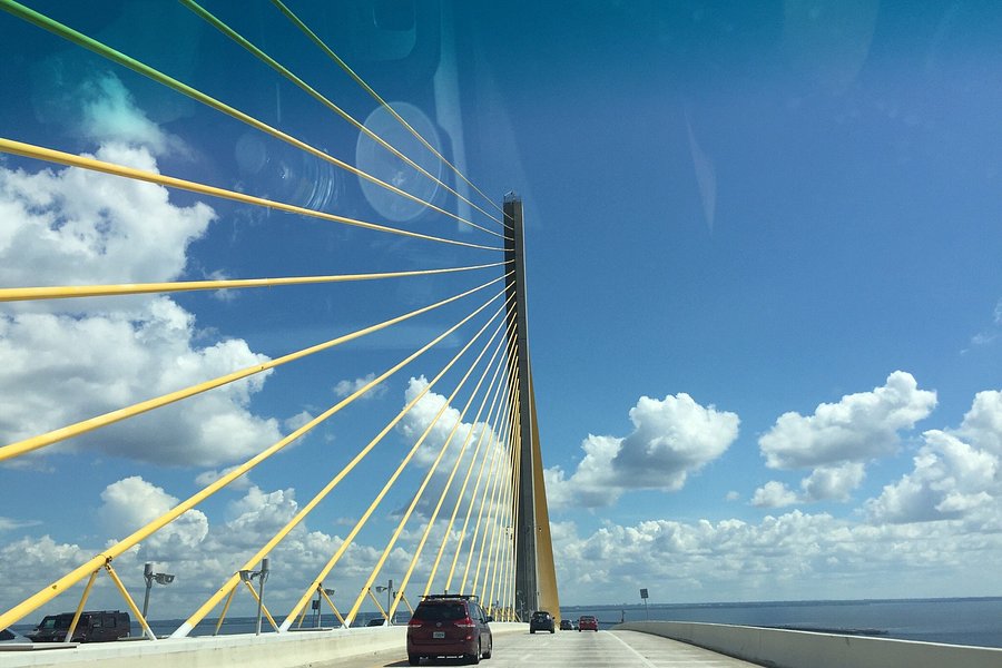
The Skyway bridge collapsed 40 years ago. Here’s how we’re remembering the tragedy.
- Gabrielle Calise Times staff
Saturday marks 40 years since the 19,734-ton Summit Venture freighter slammed into the old Skyway bridge. Six cars, a truck and a Greyhound bus plummeted 150 feet into the choppy waters of Tampa Bay below. Thirty-five died.
The Skyway disaster remains one of the most tragic in Florida history.

40 years after the Skyway bridge disaster, divers can’t forget what they saw underwater
Diver Robert Raiola is still haunted by that stormy morning he and his partner, Michael Betz, spent pulling bodies from the water.
For nearly four decades, their story was untold. Now Raiola wants their grandchildren to know what they saw. Read the story here .
The first Skyway bridge opened 66 years ago. It was a triumph. Then came the tragedy.
Here’s the origin story behind the iconic bridge, from its opening day to the stormy morning of May 9, 1980. Read it here .
What happened to those who made headlines after the Skyway bridge accident?
Read more on the pilot who crashed, the attorney who defended him and some of those who nearly lost their lives 40 years ago.
See historic photos from the Sunshine Skyway bridge disaster
We combed through the Times archives to share jaw-dropping images from the historic day. View the gallery here.
Here’s what readers remember from the day the Skyway bridge fell
The foggy morning of May 9, 1980, left strong memories that have stayed with many readers. Read some of those memories here.
At the scene of the Skyway Bridge collapse, detachment gave way to grim reality
Read a column from Times CEO and chairman Paul Tash, who covered the Skyway Bridge disaster as a 25-year-old reporter. He recalls wondering if what he was seeing through his binoculars was real or an optical illusion.
The 35 victims of the 1980 Sunshine Skyway Bridge Disaster:
Michael Curtin, 43, of Apollo Beach
Duane Adderly, 21, of Miami
Louis Lucas Jr., 62, of Dolomite, Ala.
Yvonne Johnson, 22, of Perrine
Manesha McGarrah, 7 months, of Tallahassee
Wanda McGarrah, 24, of Tallahassee
Sharon Dixon, 21, of Miami
Myrtle Brown, 58, of St. Johns, Newfoundland
Willis Brown, 57, of St. Johns, Newfoundland
Aubrey Hudson, 62, of St. Johns, Newfoundland
Phyllis Hudson, 58, of St. Johns, Newfoundland
John Carlson, 47, of Pinellas Park
Doris Carlson, 42, of Pinellas Park
Tawana McClendon, 20, of Palmetto
Charles Collins, 40, of Tampa
Leslie Coleman Jr., 52, of St. Petersburg
James Pryor, 42, of Seminole
Spend your days with Hayes
Subscribe to our free Stephinitely newsletter
You’re all signed up!
Want more of our free, weekly newsletters in your inbox? Let’s get started.
John Callaway Jr., 19, of Miami
Horace Lemmons, 47, of Kings Mountain, N.C.
Gerda Hedquist, 92, of Charlotte Harbor
Louise Johnson, 59, of Cataula, Ga.
Melborne Russell, 38, of Chicago, Iill.
Robert Harding, 63, of Glens Falls, N.Y.
Alphonso Blidge, 22, of Miami
Marguerite Mathison, 82, of St. Petersburg
Sandra Davis, 34, of Boardman
Hildred Dietch, 73, of St. Petersburg
Harry Dietch, 68, of St. Petersburg
Lillian Loucks, 69, of Winnipeg, Manitoba
Ann Pondy, 57, of Winnipeg, Manitoba
Brenda Green, 19, of Miami
Delores Smith, 50, of Pennsville, N.J.
Robert Smith, 37, of Pennsville, N.J.
Laverne Daniels, 20, of Miami
Woodrow Triplett, 33, of Bainbridge, Ga.
Culture, music and nostalgia reporter
MORE FOR YOU
- Advertisement
ONLY AVAILABLE FOR SUBSCRIBERS
The Tampa Bay Times e-Newspaper is a digital replica of the printed paper seven days a week that is available to read on desktop, mobile, and our app for subscribers only. To enjoy the e-Newspaper every day, please subscribe.
Baltimore bridge collapse brings back memories of Florida's Sunshine Skyway bridge disaster

A Baltimore, Maryland, bridge partially collapsed about 1:30 a.m. Tuesday after being hit by a cargo ship.
Nearly 12 hours after the collapse, a massive search effort continued for six construction workers who were on the bridge at the time. Several vehicles also were on the bridge at the time of impact and plunged into the river. As of early Tuesday afternoon, two people have been rescued. One was unharmed and the other remains in "very serious condition."
Officials said the crew on the ship warned of a power issue and sent out a "mayday" before the collision.
➤ Photos, video show collapse of Francis Scott Key Bridge
➤ Live coverage: Francis Scott Key Bridge collapses, rescue operations underway
The incident brings back memories of a similar incident that happened in Florida when a freighter hit the Sunshine Skyway bridg e in 1980.
A 1,200-foot section of the bridge collapsed, sending several cars and a Greyhound bus into the waters of Tampa Bay. Thirty-five people died.
Here's what is happening in Maryland this morning, along with happened in Florida decades ago.
What happened in the bridge collapse in Baltimore, Maryland?
The Francis Scott Key Bridge collapsed early Tuesday after it was struck b y a large cargo ship, The bridge is a major span critical to East Coast shipping.
The Baltimore City Fire Department received several 911 calls around 1:30 a.m. Several vehicles were reported in the river, and the ship had caught fire.
Live updates: Baltimore's Key Bridge collapses after ship collision; rescue effort underway
"This is currently a mass casualty incident and we are searching for seven people who are in the river," Kevin Cartwright, director of communications for the Baltimore Fire Department, told Reuters.
“Our focus right now is trying to rescue and recover these people.”
Synergy Marine Corp said the Dali, Singapore-flagged container ship, collided with one of the pillars of the bridge. All its crew members, including two pilots, have been accounted for and there were no reports of any injuries.
Where is Baltimore?
Baltimore is located about 35 miles northeast of Washington, D.C. or about 90 miles southwest of Philadelphia.
Where is Francis Scott Key Bridge and when did it open?
The Francis Scott Key Bridge opened in March 1977 as the final link in Interstate 695, the Baltimore Beltway.
The 1.6 mile bridge crosses over the Patapsco River where Francis Scott Key reportedly was inspired to write the words of the Star Spangled Banner, according to the Maryland Transportation Authority.
The bridge consists of four lanes and is 185 feet high. The cost to build it was $60.3 million. The bridge can handle 11.3 million vehicles per year, or nearly 31,000 cars per day, according to the transportation authority.
More about Key Bridge: Where is the Francis Scott Key Bridge? What to know about collapsed Baltimore bridge
Ship hit Florida's Sunshine Skyway Bridge in 1980
On May 9, 1980, the freighter Summit Venture struck the bridge that joined St. Petersburg and Bradenton during a thunderstorm, that brought wind gusts in excess of 80 mph and heavy rain. Visibility when the freighter hit one of the Sunshine Skyway Bridge was near zero, according to skywaybridgedisaster .com.
A 1,200-foot section of the bridge collapsed, sending several cars and a Greyhound bus into the waters of Tampa Bay.
Thirty-five people died.
A new bridge opened in 1987 and the approaches to the old span are now fishing piers.
Contributors: Charles Ventura, Thao Nguyen, Susan Miller, USA Today Network
Strong winds propel derelict boats into the Royal Park Bridge

A pair of derelict sailboats that drifted into the north side of the Royal Park Bridge this week were removed from the water on Tuesday, a West Palm Beach Police Department spokesperson confirmed.
The vessels, which were tethered together, were carried along the Intracoastal by a strong current and high winds before they hit the bridge around 4:30 p.m. Monday, department PIO Mike Jachles said Tuesday.
The collision was not a violent one, Jachles told the Daily News .
More: Boat show opens Thursday; JFK's Honey Fitz will be on display
Related: Seven boats that broke loose during Hurricane Nicole washed ashore in Palm Beach
"One of the masts apparently broke on the sailboat," he said. "But it's not like they went crashing in there. They just kind of drifted with the current into the bridge, which was on the Palm Beach side."
A Florida Department of Transportation spokesman said Tuesday that the vessels most likely were privately owned recreational boats that were unmanned when they drifted into the bridge, which connects West Palm Beach to Palm Beach.
The FDOT owns the bridge, which opened to traffic in 2005 after a $77.4 million replacement project.
"They slipped their anchorage and drifted towards the bridge due to high winds," said Guillermo Canedo, communications manager for FDOT. "The two boats were about 30 feet or less in length."
Because of the strength of the current, the vessels remained in the water for a day before they were removed by Sea Tow, a Riviera Beach-based boat towing company, Jachles said.
West Palm Beach Police's marine unit was in the water on Monday, but officers did not actively address the incident, Jachles said.
"We don't have the authority to remove those boats," he said. "We were just there making sure there was no threat to public safety."
The authority to remove the boats rested with the Palm Beach International Boat Show because it has leased the waterway, Jachles said. The annual event runs Thursday through Sunday.
There was no damage to the bridge as a result of Monday's incident, Canedo said. Vehicular and marine traffic were not impacted.
The Royal Park Bridge is one of three bridges that connect West Palm Beach to Palm Beach. The others are the Southern Boulevard Bridge to the south and Flagler Memorial Bridge to the north.
Jodie Wagner is a journalist at the Palm Beach Daily News , part of the USA TODAY Florida Network. You can reach her at [email protected] . Help support our journalism. Subscribe today.

High winds send 30-foot sailboat crashing into Florida bridge, where it sinks
A sailboat that was too tall crashed into a Florida bridge that was too short and sank in Destin Harbor, state officials say.
It happened Thursday, April 13, near Destin, 45 miles east of Pensacola, according to the Florida Fish and Wildlife Conservation Commission.
“Preliminary information indicates that, due to high winds, a sailboat anchored in Destin Harbor was blown into the Marler Bridge in Okaloosa County,” the commission told McClatchy News.
“The vessel has sunk outside of the main navigable channel. The FWC is conducting an investigation into the incident.”
A photo shared on Facebook by the Okaloosa County Sheriff’s Office showed the 30-foot-long boat’s mast was too tall to pass under the 49-foot-tall bridge. The mast struck the bridge as traffic passed overhead.
“Yes, it is definitely a hazard, and yes the Coast Guard will be marking it with the buoy,” the sheriff’s office said in a release.
Among the witnesses was Gil Osterloh, who posted video on Facebook showing the boat appeared to be uncrewed as winds pushed it across the harbor. It is seen slamming directly into a pier, then spins around before becoming pinned to the bridge.
Gusts as high as 30 mph and breaking waves of 4 to 6 feet were forecast for the area.
The boat slowly took on water over a period of hours and flipped onto its side. Only the top of the mast remained visible after it sank, photos show.
Investigators did not report anyone was aboard.
Boat crashes into Florida bridge, leaving 10 people struggling in river, rescuers say
Friend couldn’t find teen who fell off jet ski in Florida bay. Rescuers rush to water
Search on for driver of vehicle that fell off bridge into Florida river, cops say
©2023 The Charlotte Observer. Visit charlotteobserver.com. Distributed by Tribune Content Agency, LLC.


Whoops: Boat gets worst of it after slamming…
Share this:.
- Click to share on Facebook (Opens in new window)
- Click to share on X (Opens in new window)
Daily e-Edition
Evening e-Edition
- Election 2024
- Restaurants
- Real Estate
- Things To Do
SUBSCRIBER ONLY
Whoops: boat gets worst of it after slamming into south florida bridge.

It’s a sight rarely seen in these parts, where boats come and go all day long without incident: A 137-foot party yacht wedged under Fort Lauderdale’s busy Sunrise Boulevard Bridge on a balmy Saturday night.
Neighbor Mark Addison started recording the spectacle after hearing screaming passengers and a loud crunching noise.
The Sun Dream was attempting to dock at the Doubletree Suites hotel next to the Intracoastal when the boat slammed into the bridge. The crew blamed it on wind gusts and a mechanical problem.
“As funny as it was, thank God no one got hurt,” said Suzee Bailey, president of the Nurmi Isles Homeowners Association. “But did it do any damage to the bridge? And will our city do anything about it?”
The boat probably took more of a hit than the bridge, said John Fiore, a boating expert and longtime member of Broward County’s marine advisory board.
“I hope they have insurance,” he said. “The state’s going to want their bridge fixed if they damaged it. At a low speed I would suspect the damage would be minimal. I would think the boat took the brunt of the damage. Bridges are built really solid and boats are built light. So the boat’s going to be the loser.”

City officials initially told the South Florida Sun Sentinel they were unsure whether the bridge had been damaged.
But late Sunday, Fort Lauderdale City Manager Chris Lagerbloom said state officials told him they’d already been out to inspect the bridge and found no damage.
The company website for Sun Dream Yacht Charters says the family-owned business has been hosting weddings, holiday parties and elegant celebrations for more than 32 years.
Bob Brantmeyer, president of Sun Dream Yacht Charters, said a mechanical problem caused the the bow of the vessel to travel under the bridge.
“The crew quickly identified the issue and docked the vessel safely,” he said. “There were no injuries to crew or passengers and light cosmetic damage to the vessel.”
Brantmeyer says he has coordinated with the relevant authorities and safety remains his top priority.
“Apparently they had some transmission problems and the boat got away from them,” Fiore said. “A boat like that might weigh around 100 tons. And it doesn’t stop easily. The bottom line, apparently no one was hurt. That’s the good thing.”
Longtime resident Tom Godart chalked the whole thing up to a freak accident.
“I’ve been in Fort Lauderdale 34 years and I’ve never heard of that happening,” he said.
Godart wasn’t too worried about damage to the bridge.
“I just went over the bridge,” Godart said while on his way to a park with his daughter. “I went over the bridge and we were safe.”
Susannah Bryan can be reached at [email protected] or on Twitter @Susannah_Bryan
More in Local News
")
Local News | Fort Lauderdale city manager calling it quits

Local News | Morning Update: South Florida’s top stories for Wednesday, April 3, 2024
")
Politics | National Democrats gather to mobilize on abortion, warn of threats to IVF and contraception

Local News | 911 call | Former NFL standout Vontae Davis was found unresponsive in home gym
- Election 2024
- Entertainment
- Newsletters
- Photography
- Personal Finance
- AP Buyline Personal Finance
- Press Releases
- Israel-Hamas War
- Russia-Ukraine War
- Global elections
- Asia Pacific
- Latin America
- Middle East
- Election Results
- Delegate Tracker
- AP & Elections
- March Madness
- AP Top 25 Poll
- Movie reviews
- Book reviews
- Personal finance
- Financial Markets
- Business Highlights
- Financial wellness
- Artificial Intelligence
- Social Media
A list of major US bridge collapses caused by ships and barges
Baltimore’s Francis Scott Key Bridge collapsed after a container ship lost power and rammed into the bridge early Tuesday, sending vehicles plunging into the water. Six people are still unaccounted for.
FILE - A car is halted at the edge of the Sunshine Skyway Bridge across Tampa Bay, Fla., after the freighter Summit Venture struck the bridge during a thunderstorm and tore away a large part of the span, May 9 1980. A container ship struck a major bridge in Baltimore early Tuesday, March 26, 2024, causing it to plunge into the river below. From 1960 to 2015, there have been 35 major bridge collapses worldwide due to ship or barge collision. (AP Photo/Jackie Green, File)
- Copy Link copied
FILE - The Popp’s Ferry Bridge in Biloxi, Miss. is seen on Friday, March 20, 2009 after it was hit and damaged by a barge trying to navigate through the drawbridge. A container ship struck a major bridge in Baltimore early Tuesday, March 26, 2024, causing it to plunge into the river below. From 1960 to 2015, there have been 35 major bridge collapses worldwide due to ship or barge collision. (William Colgin/The Sun Herald via AP)
FILE - A section of the Queen Isabella Causeway is shown missing as crews break from their search and rescue due to a stormm in Port Isabella, Texas on Saturday, Sept. 15, 2001. A container ship struck a major bridge in Baltimore early Tuesday, March 26, 2024, causing it to plunge into the river below. From 1960 to 2015, there have been 35 major bridge collapses worldwide due to ship or barge collision (AP Photo/Eric Gay, File)
Parts of the Francis Scott Key Bridge remain after a container ship collided with one of the bridge’s support Tuesday, March 26, 2024 in Baltimore. The major bridge in Baltimore snapped and collapsed after a container ship rammed into it early Tuesday, and several vehicles fell into the river below. Rescuers were searching for multiple people in the water. (WJLA via AP)
Follow AP for live coverage of Baltimore’s Key Bridge collapse
A container ship struck a major bridge in Baltimore early Tuesday, causing it to plunge into the river below. From 1960 to 2015, there were 35 major bridge collapses worldwide due to ship or barge collision, with a total of 342 people killed, according to a 2018 report from the World Association for Waterborne Transport Infrastructure. Eighteen of those collapses happened in the United States.
A list of notable disasters involving ships or barges hitting bridges in the U.S.:
POPP’S FERRY BRIDGE
March 20, 2009: A vessel pushing eight barges rammed into the Popp’s Ferry Bridge in Biloxi, Mississippi, resulting in a 150-foot section of the bridge collapsing into the bay.
INTERSTATE 40 BRIDGE: 14 DEAD
May 26, 2002: A barge hit the Interstate 40 bridge over the Arkansas River at Webbers Falls, Oklahoma, collapsing a 500-foot section of road and plunging vehicles into the water. Fourteen people died and 11 were injured.
QUEEN ISABELLA CAUSEWAY: 8 DEAD
Sept. 15, 2001: A tugboat and barge struck the Queen Isabella Causeway in Port Isabel, Texas, causing a midsection of the bridge to tumble 80 feet into the bay below. Eight people died after motorists drove into the hole.
EADS BRIDGE: 50 INJURED
April 14, 1998: The Anne Holly tow traveling through the St. Louis Harbor rammed into the center span of the Eads Bridge. Eight barges broke away. Three of them hit a permanently moored gambling vessel below the bridge. Fifty people suffered minor injuries.
BIG BAYOU CANOT: 47 DEAD
Sept. 22, 1993: Barges being pushed by a towboat in dense fog hit and displaced the Big Bayou Canot railroad bridge near Mobile, Alabama. Minutes later, an Amtrak train with 220 people aboard reached the displaced bridge and derailed, killing 47 people and injuring 103 people.
SEEBER BRIDGE: 1 DEAD
May 28, 1993: The towboat Chris, pushing the empty hopper barge DM3021, hit a support tier of the Judge William Seeber Bridge in New Orleans. Two spans and the two-column bent collapsed onto the barge. Two cars carrying three people fell with the four-lane bridge deck into a canal. One person died and two people were seriously injured.
SUNSHINE SKYWAY BRIDGE: 35 DEAD
May 9, 1980: The 609-foot freighter Summit Venture was navigating through the narrow, winding shipping channel of Florida’s Tampa Bay when a sudden, blinding squall knocked out the ship’s radar. The ship sheared off a support of the Sunshine Skyway Bridge, dropping a 1,400-foot section of concrete roadway during the morning rush hour. Seven vehicles, including a bus with 26 aboard, fell 150 feet into the water. Thirty-five people died.
Sunshine Skyway Bridge
Most Recent: Reviews ordered by most recent publish date in descending order.
Detailed Reviews: Reviews ordered by recency and descriptiveness of user-identified themes such as wait time, length of visit, general tips, and location information.
Also popular with travelers
Sunshine Skyway Bridge - All You Need to Know BEFORE You Go (2024)
- Stunning Helicopter Tour - Skyway Bridge, Fort Desoto & St. Pete Beaches (From $173.00)
- Magnificent Helicopter Tour -Tampa Bay, Skyway Bridge, Beaches of Pinellas Co. (From $235.00)
- 4-Hour St. Pete Pier to Egmont Key Experience by Ferry (From $66.67)
- Island Sunset and Skyway Light Show in St. Petersburg (From $79.10)
- 2-Hour Sunset Cruise Tour in St. Petersburg (From $66.67)
- (7.17 mi) Sunrise Garden Resort
- (4.61 mi) Fort de Soto Park Campground
- (7.32 mi) Anna Maria Motel Resort
- (7.26 mi) Residence Inn by Marriott St. Petersburg Tierra Verde
- (7.52 mi) Island's End Resort
- (7.20 mi) Hometown Desserts
- (9.75 mi) Buona Ristorante
- (9.66 mi) Slicker's Eatery
- (7.72 mi) The Ugly Grouper
- (8.57 mi) Holy Cow Ice Cream & Other Cool Stuff
- (3.83 mi) C Ponies Beach Horses
- (6.72 mi) Get Up And Go Kayaking - Tampa Bay
- (5.22 mi) Island Kayak Tours, LLC
- (5.79 mi) Five O'Clock Charlie Boat Tours
- (5.64 mi) ECOmersion
ROGUE BOAT: A boat collides with Punta Gorda bridge

PUNTA GORDA, Fla. — A boat floated into the US 41 bridge in Punta Gorda on Wednesday morning.
According to the Charlotte County Sheriff's Office, no one is believed to have been on the boat when it crashed. A spokesperson told Fox 4 there is no damage to the bridge column or vessel.
FWC and Florida Highway Patrol are at the scene, slowing down traffic going southbound.
Sign up for the Headlines Newsletter and receive up to date information.
Now signed up to receive the headlines newsletter..

News In Your Neighborhood
Advertisement
fender system
Island Barrier
How Fenders Might Have Protected Against Bridge Collapse
By K.K. Rebecca Lai , Anjali Singhvi and James Glanz
The Francis Scott Key Bridge did not have an obvious fender system, or protective barriers, to redirect or prevent a ship from crashing into the bridge piers.
Francis Scott
Patapsco River
The New York Times; aerial image via Nearmap
Engineers point out that some other bridges have more robust barriers. The Verrazzano-Narrows Bridge in New York City has rock walls surrounding its piers.
Verrazzano-Narrows
New York Harbor
STATEN ISLAND
The New York Times; aerial image via Vexcel Imaging
Island barriers were installed around the Sunshine Skyway Bridge piers in Tampa Bay, Fla., after a ship crash caused the span’s collapse in 1980.
Sunshine Skyway
Even smaller bridges like this one near Cape May, N.J., have fenders.
Cape May county, N.J.
Grassy Sound Channel
The New York Times; image via Creative Composites Group
In bridge engineering , fenders can be anything from simple pyramids of rocks piled around the pylons to major concrete rings padded with slats of wood, designed to shield the bridge’s supports from damage by water or collisions.
While a full determination is not yet possible, some engineers told The Times that the collapse of the Key Bridge might have been avoided if its piers had more effective barriers.
- Share full article
Why the Baltimore bridge stood little chance against a fully loaded cargo ship
As questions surround the collapse of a Baltimore bridge after a containership crashed into it Tuesday, engineering experts say that while bridges have some built-in defenses against collisions, this one was most likely too extreme to withstand.
“Bridges are and should be designed to withstand ship impacts. That’s typical of the design process,” said Sanjay R. Arwade, a professor of civil engineering at the University of Massachusetts Amherst.
“But for all structures and all engineered systems, there is a possibility that an event will occur that is beyond what the structure was designed for. And this may be one of those situations,” he added.
The Francis Scott Key Bridge, a roughly 1.5-mile-long steel arch truss bridge, collapsed into the Patapsco River early Tuesday after a containership struck it. Several vehicles crashed into the water, and one of the country’s busiest ports shut down.
Follow live updates on the Baltimore bridge collapse
An unknown number of workers with Brawner Builders Inc. were repairing concrete ducts when the ship, called the Dali, hit a support pillar. Six employees are presumed dead .
Key Bridge was ‘fairly unprotected'
Arwade said design codes for modern bridges stipulate "what sort of loads it has to be able to resist.”
“Whenever a design code is written, decisions have to be made about what the most extreme conditions are,” he said.
Maryland Gov. Wes Moore said the bridge was "fully up to code."
But the Key Bridge was built in 1977, and bridge design and technology have improved since then.
"Since the 1970s, we have a lot of advancements," Sameh Badie, a professor of engineering at George Washington University, told NBC Washington. But he said, "I saw today a couple of videos before the collapse, and it seems to me, structurally wise, it was very safe."
Roberto Leon, a structural engineer at Virginia Tech, said that while engineers try to account for “extreme events” during the design and construction process, “when this bridge was built, there were no ships of this size.”
“This type of load was not really considered,” he said. “So the bridge was, I would say, fairly unprotected.”
Retrofitting older bridges could cost millions
Officials have not specified what type of protective infrastructure, if any, the Key Bridge had.
Leon said that on a newer bridge, large concrete structures called dolphins are often used to protect the base. Dolphins can form a kind of frame and are designed to take the impact of a vessel and “slow the ship down and redirect it away from the bridge,” he said.
“In some cases, they’re called sacrificial elements, because they might be damaged beyond repair if an event of this type occurs, but of course, they save the bridge,” he added.
John Pistorino, a structural engineer in Florida, said dolphins are in use to protect the Sunshine Skyway Bridge in Tampa, Florida, which was reopened in 1987 , seven years after it was hit by a freighter. Thirty-five people died after the bridge collapsed into Tampa Bay.
Pistorino, who was involved in the construction of the rebuilt Sunshine Skyway Bridge, described dolphins as walls or guardrails.
“They can be concrete or steel … and they go all the way down to the bottom of the river,” he said. “They’re supposed to protect the abutments.”
Jacksonville, Florida, Mayor Donna Deegan cited the dolphin infrastructure that's in place to protect the Dames Point Bridge — the only bridge in the city that cargo ships sail under — in a statement Tuesday. She noted that the bridge is also equipped with specialty sensors that provide real-time information about the distance between the water surface and the bottom of the bridge structure over the main channel.
Older and more vulnerable bridges can be retrofitted to add defensive infrastructure like dolphins, Leon said, but building them can cost hundreds of millions of dollars.
“I’m hoping that because of the infrastructure bill that passed, we are going to be able to do projects like this,” he said, referring to the $555 billion infrastructure bill that President Joe Biden signed in 2021. “Putting those into the budget and justifying them is very difficult when you have all kinds of other bridges that are in really sad shape. So it’s just a question of prioritization.”
However, Kevin Heaslip, director of the Center for Transportation Research and a professor of civil and environmental engineering at the University of Tennessee, Knoxville, said the cost of designing bridges to withstand fully loaded cargo ships like the Dali would “be so high that we wouldn’t be able to have any bridges.”

Government oversight of bridges could increase
Transportation Secretary Pete Buttigieg said he has been monitoring the situation in Baltimore. A team of investigators from the National Transportation Safety Board has been sent to the crash site.
Leon said he hopes what happened in Baltimore will cause port operations to change “quite a bit.” Pistorino said the event may lead legislators to take a closer look at vulnerable bridges in the country and the types of maritime traffic in ports.
“Just like the building collapse in South Florida created a lot of legislation that required a more intimate type of building scrutiny, I think that will happen on the bridges,” he said.
Minyvonne Burke is a senior breaking news reporter for NBC News.
Republicans put forth unfounded and sometimes racist theories on bridge collapse

After Tuesday’s deadly collapse of the Francis Scott Key Bridge in Baltimore, some Republican officials, candidates and right-wing pundits attempted to connect the tragedy to some of their most frequent political targets: diversity initiatives, illegal immigration, coronavirus lockdowns and the Biden administration. And early reaction to the incident also provided fresh ground for unfounded theories that the collapse was not an accident at all.
The collapse along a key East Coast corridor early Tuesday sent at least eight people into the Patapsco River. The remains of two people have been recovered, and four others are presumed dead. They were immigrant construction workers making bridge repairs at the time of the collapse.
Since the incident, several sitting Republican officials have sought to tie the Biden administration to the collapse of the nearly 50-year-old bridge.
Rep. Nancy Mace (R-S.C.) told Newsmax on Tuesday that the government is focusing on spending federal funds on “waste,” “when it could be going to things that are the government’s purpose, just like this.”
“We’re not spending it on roads and bridges. Look at the $1.2 trillion infrastructure bill that was done a couple of years ago that the left hails as this massive success. But it was mostly Green New Deal, actually, in that bill,” Mace said, referencing the 2021 bipartisan infrastructure bill signed into law by President Biden .
Baltimore bridge collapse

Republicans previously criticized Transportation Secretary Pete Buttigieg as not visiting East Palestine, Ohio, quickly enough after a toxic train derailment there last year. But after the secretary visited Baltimore on the day of the bridge collapse, Rep. Jeff Van Drew (R-N.J.) suggested without evidence that the visit was politically motivated and that Buttigieg was preoccupied with diversity policies.
“Well, this is an election year, so he probably, if it was two years ago might have been a month before he went at all,” Van Drew told Fox Business Network’s Maria Bartiromo on Wednesday. “He’s worried too much about pronouns, worried too much about DEI policies, worried too much about being the cool kid on the block. … I’m disappointed in the job that he does.”
Along with Van Drew, conservative political candidates and right-wing media personalities have turned to blaming diversity, equity and inclusion policies — a loosely defined term broadly used to refer to efforts to diversify the workforce and academia — for the collapse. It’s the latest in a series of issues that the right has blamed on DEI.
Utah state Rep. Phil Lyman (R) blamed DEI policies for the bridge collapse. The Utah gubernatorial candidate running against Gov. Spencer Cox (R) shared another account’s post online that attacked Port of Baltimore Commissioner Karenthia Barber, a Black woman whose biography says she owns a consulting practice that takes on work related to DEI. Responding to the post about Barber’s background, Lyman wrote on X on Tuesday morning that “this is what happens when you have Governors who prioritize diversity over the wellbeing and security of citizens.” In a subsequent post referencing the collision, he said: “DEI = DIE.”
Lyman told the Salt Lake Tribune later Tuesday that he had not authorized the comments before they were posted by his team, saying that the post about Barber “was not our best moment” and that it “was a knee-jerk reaction to some of the things others were putting out there.”
Anthony Sabatini, a Florida congressional candidate, blamed DEI for the bridge collapse in a post on X the morning of the collapse. And Hung Cao, a Republican challenging Sen. Tim Kaine (D) in Virginia, expressed similar frustrations, agreeing with conservative radio host Larry O’Connor, who said Buttigieg “spends more time talking about racial equity with regard to highways and about climate change than about focusing on the fundamentals of keeping our country and our infrastructure working.”
“They should have had the anchors ready to drop … so that you don’t run into the bridge. But like you said, they’re so worried about other things instead of infrastructure,” Cao, a Navy veteran, said in an appearance on “ O’Connor & Company ” on Tuesday morning.
Maryland officials have repeatedly said that there is no credible evidence linking the collapse to terrorism and that the evidence points to the collision being an accident. But Rep. Marjorie Taylor Greene (R-Ga.), a far-right member of Congress who has promoted baseless and debunked claims, took to X on Tuesday to question whether the collision was “an intentional attack.”
Popular far-right social media accounts and right-wing media personalities, including some with close ties to former president Donald Trump and Republicans in office, have similarly sought to link what they see as liberal policies to the Baltimore incident. Some accounts even turned to racist tropes about Baltimore Mayor Brandon Scott (D), which have been shared thousands of times.
In an interview with Sen. Rick Scott (R-Fla.) on Tuesday morning, Bartiromo, the Fox Business Network host, attempted to connect the incident to broader questions about “the potential for wrongdoing or the potential for foul play given the wide-open border.” And also that morning, Matt Schlapp, chairman of the American Conservative Union, discussed his concerns about an unqualified, “drug-addled” workforce hamstrung by coronavirus lockdowns.
“I’m one of these people that believes we’ve never fully come out of all the lockdowns and the covid issues,” Schlapp said on Newsmax. “I’m no expert on what’s going on in the seas, but all I would say is that if you talk to employers in America, they’ll tell you that filling slots with employees who aren’t drug-addled is a very huge problem. So I’m making no specific charges here, because we don’t know. … We have to kind of wake up as a country and deal with the fact that we have too many people who aren’t ready to do the job.”
Maryland Republicans have sought to send a more unifying message in response to the tragedy.
The Baltimore City Republican Party in a statement Tuesday vowed to “stand with” Maryland Gov. Wes Moore (D) in what they called “the biggest challenge of his term of office.”
Dennis Betzel, the second vice chair of the Baltimore City Republican Central Committee, emphasized that at the end of the day, “six people lost their lives.”
“That’s the beginning and the end of that conversation. I don’t care what political bent you are,” he added.
A previous version of this article misspelled the last name of a member of the Baltimore City Republican Central Committee. He is Dennis Betzel, not Dennis Bentzel. The article has been corrected.
How it happened: Baltimore’s Francis Scott Key Bridge collapsed after being hit by a cargo ship . The container ship lost power shortly before hitting the bridge, Maryland Gov. Wes Moore (D) said. Video shows the bridge collapse in under 40 seconds.
Victims: Divers have recovered the bodies of two construction workers , officials said. They were fathers, husbands and hard workers . A mayday call from the ship prompted first responders to shut down traffic on the four-lane bridge, saving lives.
Economic impact: The collapse of the bridge severed ocean links to the Port of Baltimore, which provides about 20,000 jobs to the area . See how the collapse will disrupt the supply of cars, coal and other goods .
Rebuilding: The bridge, built in the 1970s , will probably take years and cost hundreds of millions of dollars to rebuild , experts said.

Entrances, Inlets, & Passes - Florida’s East Coast
Florida’s east coast entrances, inlets, & passes.
Whether you are making use of the Atlantic Intracoastal Waterway or sailing coastwise along Florida’s East Coast, numerous Entrances, Inlets, or Passes exist between the deep waters of the Atlantic Ocean and the inland waters of Florida.
At last count, in January 2020 there were 19 entrances, inlets, or passes found along the east coast of Florida. Beginning at St. Marys Entrance at the Georgia/Florida Stateline in the north and Government Cut in Miami to the south. While all of these inlets provide access to sheltered waters, many provide access to the Atlantic Intracoastal Waterway.
Many of these entrances and inlets are only suitable for very shallow draft vessels and strong local knowledge, some can be considered navigable for most vessels. We have listed them below along with useful information on each to aid you in deciding if you wish to use a particular inlet.
Entrances, Inlets, and Passes
St. Marys Entrance
Lying on the Florida/Georgia State Line, St. Marys Entrance is 19.9 NM southward of St. Simons Sound, GA Approach Buoy "STS", and 19.7 NM northward of St. Johns River Entrance, FL Approach Buoy "STJ."
The St. Marys Entrance affords access to Fernandina Beach, FL, St. Marys and Kings Bay, GA and the Atlantic Intracoastal Waterway.
NOAA Chart #11503 - St. Marys Entrance - Cumberland Sound and Kings Bay is suggested for the approach and entrance. NOAA Chart #11502 - Doboy Sound to Fernandina may also be used as an alternate for the approach to St. Marys.
The Atlantic Intracoastal Waterway is intersected 2.5 NM above the entrance near lighted buoy (Y "E" Fl Y 2.5s) at (MM "713.7").

The approach to St. Marys Entrance is marked by lighted buoy (RW “STM” Mo(A) AIS) and is located 8.2 NM east of St. Marys Entrance at (30°42’54" N / 81°14’39" W). The approach channel through the bar is deep (40+ feet)and well-marked with lighted buoys and ranges.
Prominent on the approach is Amelia Island Light (Fl 10s 107ft 19M) located 2 NM southward of the entrance. It is reported that the light is difficult to distinguish during daytime hours. Also prominent from seaward is a 295 foot-high processing tower southward of the entrance. The tower is marked at night by flashing red lights. Smoke from the stacks of the paper companies at Fernandina Beach and St. Marys make them easily visible from all directions.
St. Marys Entrance is between two stone jetties. The jetties are reported to be in very poor condition with both almost entirely submerged at mean high water. The north jetty is marked off its outer end by a lighted buoy (R "2NJ" QR). White buoys with orange bands also mark the approximate location of the north and south jetties. The entrance is deep (40+ feet), wide, and well-marked with lighted buoys and ranges.
Tides & Currents
Tides & Currents - The mean tidal range at the entrance is 5.8 feet. The tidal currents at the entrance have considerable velocity and are dangerous at times. Maximum current velocities are reported to be 2.0 to 3.9 knots in St. Marys Entrance. Freshets in the St. Marys River may cause the ebb to run for 7 to 8 hours. Velocities exceeding 5 knots have been reported to occur.
Cautions - Mariners are advised to exercise caution at the entrance. The jetties can be hazardous to navigation when visibility is limited. Currents are strong off the ends of the jetties. The natural channel between the jetties is subject to frequent change.
An ebb current inside the jetties opposed by a moderate to strong easterly wind often creates 4 to 7 foot seas in the entrance.
Hydrographic Surveys
The most recent hydrographic depth survey for: St. Marys/Fernandina
Nassau Sound Entrance
Nassau Sound Entrance is located 15 NM southward of the St Marys Approach Buoy "STM" and 7.1 NM northward of St. Johns River Approach Buoy "STJ."

The approach is unmarked and is obstructed by shifting shoals that extend about 1.5 miles seaward and form a shallow bar with depths of 1 to 7 feet. Breakers form across the entire approach. Vessels are advised not to attempt passage through the shoals without local knowledge.
The entrance is uncharted and unmarked. It is shallow and shoal with depths of 1/2 to 25 feet. Unmarked wrecks exist in the entrance. It has (2) fixed bridges 1 NM above the entrance with a vertical clearance of 15 feet.
The mean range of tide in Nassau Sound is 5.4 feet.
Local Knowledge Required.
Breaking bar across entire approach and entrance.
Ft. George Inlet
Fort George Inlet is a small inlet 1.5 NM northward of St. Johns River entrance and lying between Little Talbot Island to the north and Fort George Islands to the south.
The inlet changes rapidly due to shifting sands at its entrance and should never be used without local knowledge.

The approach is unmarked and is obstructed by shifting shoals that extend about 0.7 NM seaward and form a shallow bar with depths of ½ to 3 feet.
The entrance is uncharted and unmarked. It is shallow and shoal, frequently going bare at low water. The area is subject to frequent changes. A fixed bridge at the entrance has a vertical clearance of 15 feet. An overhead power cable adjacent to the bridge has a clearance of 40 feet.
The mean range of tide at Ft. George inlet is ≈5.0 feet.
Local knowledge is required when using this inlet. This inlet should be considered unnavigable for most vessels.
St. Johns River Entrance
St. Johns River Entrance is 19.7 NM SSW of St. Marys Entrance and 28.8 NM northward of St. Augustine Inlet. St. Johns River Entrance provides access to the St. John River, Mayport, the AICW, Jacksonville, and Palatka, FL.
NOAA Chart #11490 - Approaches to St. Johns River is suggested for the approach to St. Johns River while the same NOAA Chart #11490 - St. Johns River Entrance is also suggested for the entrance. Additionally, NOAA Chart #11489 - St. Simons Sound to Tolomato River will be required for the intersection with the AICW.
The Atlantic Intracoastal Waterway can be intersected approximately 5.0 NM above the entrance near lighted buoy (G "1" Fl G 4s) at (MM "740.0").

The approach is marked by a lighted buoy (RW "STJ" Mo(A) AIS) about 3.0 NM east of the entrance jetties located at 30°23’35"N / 081°19’08.398W.
Prominent on the approach is St. Johns Light (Fl(4) 20s 83ft 19M) located at (30°23’10"N., 81°23’53"W. and shown from a white square tower on the beach about 1 NM south of St. Johns River south jetty. Water tanks are prominent along the beaches southward of St. Johns Light.
The entrance channel is protected by jetties. It is deep (40 to 50 feet to Pilot Town Cut Range) and 34 to 40 feet beyond. It is well marked with lighted buoys and ranges as far as downtown Jacksonville.
The mean range of tide is 4.9 feet at St. Johns River entrance. Strong northerly and northeasterly winds raise the water level about 2 feet at Jacksonville and about 1 foot at Palatka, FL. Strong southerly and southwesterly winds lower the water level about 1 to 1.5 feet, increase the ebb, and decrease or may interrupt the flood.
The tidal currents are strong in St. Johns River as far as Jacksonville. The velocity of the current between the jetties is 2 knots on the flood and 4 knots on the ebb; at Mayport, 2.2 knots on the flood and 4 knots on the ebb; at Mile Point, 2.7 miles above the mouth, about 2.8 knots. At downtown Jacksonville (Commodore Point), the velocity of current is about 1.0 knot. The tidal currents above Jacksonville average less than a knot. The currents in Deep Creek are weak, being due primarily to the winds and tide. The flood is increased by northeasterly and easterly winds and the ebb by southwesterly and westerly winds.
The Atlantic Intracoastal Waterway’s junction with the St. Johns River is subject to strong and unpredictable crosscurrents at various stages of the tide.
The Bar Pilots report that 1 hour after the beginning of strong winds from anywhere between north through east to south, a very strong current sets up with the wind across the end of the jetties, and the condition is usually dangerous; when such winds reach gale force, the positions of the buoys should not be relied upon as they may drag from station.
The most recent hydrographic depth survey for: St. Johns Entrance/Jacksonville
St. Augustine Inlet
St. Augustine Inlet is found 30 NM south of the St. Johns River entrance, 12.6 NM NNW of Matanzas Inlet, and 53.5 NM NNW of Ponce de Leon Inlet and Daytona Beach, FL. The inlet provides access to St. Augustine, Anastasia Island, and the AICW.
NOAA Chart #11488 - Amelia Island to St. Augustine is suggested for the approach to St. Augustine while NOAA Chart #11485 - Tolomato River to Palm Shores is lacking, but the best available for the entrance.
The Atlantic Intracoastal Waterway can be intersected about 0.5 NM above the entrance near buoy (G "59" Fl G 2.5s) at (MM "776.4").

The approach is marked by lighted buoy (RW "STA" Mo(A) WHIS) 1.7 NM east of the entrance at 29°54’ 55" N / 081°15’ 17" W. The shore should be given a berth of at least 2 miles when approaching St. Augustine Inlet in order to stay outside of the outer sea buoy. All other approach buoys are uncharted as the channel shifts frequently.
Prominent on the approach is St. Augustine Light (Fl 30s 161ft 19M) located at 29°53’08" N / 81°17’ 19" W, shown from a conical tower with a black and white spirally banded shaft on the north end of Anastasia Island, 1.5 NM south of the entrance to St. Augustine Inlet. Other prominent features are an elevated water tank just southeast of the light, a radio tower 1.3 miles southward of the light, and the lighted cross and the radio tower in the northern part of the city.
The entrance channel to St. Augustine is protected by a jetty on the south side and is subject to frequent changes in depth and direction due to current and storm action. The uncharted entrance channel buoys mark the best water. These aids are moved frequently with changing conditions to mark the channel. Mariners are advised to seek local knowledge prior to entering.
Mean tidal range is approximately 4.5 feet.
Local knowledge highly recommended for this inlet.
Dangerous and shifting shoals extend 1 mile seaward on the approach. It is also common for a breaking sea to exist in the inlet, when there is an outgoing tide with any strong northerly wind.
The most recent hydrographic depth survey for: St. Augustine Inlet
Matanzas Inlet
Matanzas Inlet lies 11 NM southward of St. Augustine Light and 41.4 NM northward of Ponce de Leon Inlet. The inlet is obstructed by a shifting bar, and breakers that extend across the entire entrance in normal weather. It is unmarked and has a fixed bridge across the inlet with a vertical clearance of 10 feet. An overhead power cable crossing on the west side of the bridge has a clearance of 32 feet. Matanzas Inlet is reported to be "Closed to Navigation."

Ponce de Leon Inlet
Ponce de Leon Inlet is found 53 NM southward of St Augustine Light and 41 NM northwestward of Cape Canaveral Light. It affords access to the AICW, New Smyrna Beach and Daytona Beach, FL and is used by both recreational and small commercial vessels.
NOAA Chart #11484 - Ponce De Leon to Cape Canaveral is suggested for the approach to Ponce De Leon Inlet while NOAA Chart #11485 - Tolomato River to Palm Shores is suggested for the entrance.
Inside the inlet the Atlantic Intracoastal Waterway can be intersected in two different places. If northbound, 2.2 NM above the inlet near buoy (R N “2”). If southbound, 1.1 NM below the entrance near buoy (GR C).

The approach is marked by lighted buoy (R "2" Fl R 2.5s BELL) approximately 1.0 NM east of the entrance located at 29°04’46" N / 080°53’29" W. The approach is deep with a least depth of 14 feet found just off the northern jetty. It is well marked with charted lighted and unlighted buoys.
Prominent on the approach is Ponce de Leon Inlet Light (Fl (6) 30s 159ft 22M) shown from a red brick conical tower located just NNW of the inlet.
The entrance is protected by jetties with a channel that leads over a bar. The entrance is deep with a least depth of 9 feet being reported just inside the entrance. The outer end of the north jetty is marked by a light (Q 25ft 5M). The remainder of the entrance channel is reasonably well marked with lighted and unlighted buoys. The inner end of the north jetty is awash. A shoal built out from the south side of the entrance is close aboard the entrance channel with depths of 1 to 4 feet.
The current through the inlet is strong. It is reported that the average ebb is 3 knots; however, this can increase to 5 or 6 knots with southeasterly winds.
Safe navigation may be hampered by numerous recreational fishing vessels that anchor inside the north jetty. Local knowledge and extreme caution is advised when using this inlet.
The most recent hydrographic depth survey for: Ponce de Leon Inlet
Port Canaveral Inlet
Port Canaveral Inlet is located 150 NM south of the entrance to the St. Johns River and 54.4 NM northward of Ft. Pierce Inlet. It provides access to Cape Canaveral, Merritt Island, the AICW, and Cocoa, FL. Party fishing vessels, cruise ships and many pleasure craft operate from the port.
NOAA Chart #11476 - Cape Canaveral to Bethel Shoal is suggested for the approach to Port Canaveral while NOAA Chart #11478 - Port Canaveral is suggested for the entrance and NOAA Chart #11485 - Tolomato River to Palm Shores is suggested for intersection with the AICW.
The Atlantic Intracoastal Waterway can be intersected 8.0 NM above the entrance at (MM "893.8") near lighted beacon (Fl G 4s 12ft 5M "67").

The approach to Port Canaveral begins 5.7 NM SSE of Cape Canaveral Light. The outer approach limit is unmarked. The approach channel is deep (43+ feet) and well-marked by lighted buoys and ranges.
Prominent on the approach is Cape Canaveral Light (Fl (2) 20s 137ft 24M) located 3.7 NM NNE of the entrance jetties. Many Cape Canaveral launch complex structures and buildings are visible north of the inlet.
The entrance channel between the jetties is deep 40+ feet and well-marked by lighted buoys and beacons as well as a lighted range. The head of the inlet is crossed by twin bascule bridges with a closed clearance of 25 feet at the center. Just beyond the bridges is Cape Canaveral Lock used for passage into the Canaveral Barge Canal leading to the Banana River, Indian River, and
The Tidal Range is approximately 3.5 feet. There is little to no tidal currents within the entrance or the harbor due to the Canaveral Lock.
A Shoal extends southeast from Cape Canaveral approximately 6.5 NM. Caution is advised for approaches to Cape Canaveral from the north through the east. The southeastern and southern extent of the shoal are marked by lighted buoys.
Security Zones, Restricted Areas, Hazard Areas, and Danger Areas. These areas extend from Cape Canaveral to the north through east to the southeast.
The most recent hydrographic depth survey for: Canaveral Approach and Inlet
Sebastian Inlet
Sebastian Inlet is 36.5 NM southward of Cape Canaveral Light and 24.8 NM NNW of Fort Pierce Inlet. It provides access to the AICW, Roseland, Micco, and Sebastian, FL.
NOAA Chart #11476 - Cape Canaveral to Bethel Shoal is suggested for the approach to San Sebastian Inlet while NOAA Chart #11472 - Palm Shores to West Palm Beach is suggested for the entrance.
The Atlantic Intracoastal Waterway can be intersected 1.7 NM above the inlet’s entrance at (MM "936.1") near lighted beacon (Fl G 4s 16ft 5M "63")

The approach is not marked and the inlet is a narrow dredged channel, not distinguishable from any distance offshore except by the highway bridge across the inlet and by the sand spoil bank on the north side which is bare and a little higher than other sand dunes in the vicinity.
The entrance is protected by jetties. The entrance is unmarked with the exception of the north jetty which has a private lighted beacon (FL R 4s 27ft). A fixed highway bridge crosses the inlet with a vertical clearance of 37 feet.
It is reported that the velocity of the tidal currents reaches 10 knots, and turbulence exists between the bridge and the end of the jetties.
Except during flat calms, breaking and confused seas exist off the mouth of the inlet and inside the inlet as far as the bridge.
Reported shoaling exists just north of the south jetty and for about 200 yards to the east of the south jetty. Shoaling also exists in the general area south of the small spoil island between the bridge and the Intracoastal Waterway. Shoals are gradually building up and shifting. Minimum depth in the inlet varies; the bottom is rocky in spots.
Sebastian Inlet is dangerous and particularly hazardous to small boats not designed for the open seas. Passage through this inlet is not recommended except by experienced boatmen with local knowledge.
Fort Pierce Inlet
Fort Pierce Inlet is 62 NM southward of Cape Canaveral Light and 33 NM northward of Jupiter Inlet Light. It affords access to the AICW, Ft. Pierce and St. Lucie, FL.
NOAA Chart #11474 - Bethel Shoal to Jupiter Inlet is suggested for the approach to Fort Pierce while NOAA Chart #11475 - Fort Pierce Harbor is suggested for the entrance.
The Atlantic Intracoastal Waterway will be intersected 2.0 NM above the entrance at (MM "965.6") near lighted beacon (Q G 16ft 4M "17").

The approach is marked by a lighted buoy (R "2" Fl R 4s) located at 27°28’39" N / 080°15’25" W. It is deep with a controlling depth of 24.8 feet mid-channel. It is also well marked with lighted buoys and a lighted range.
Prominent on the approach are several high rise condominiums located 1 mile north of the entrance. A 210-foot meteorological tower 7.2 miles south of the entrance which is marked by a fixed red light about halfway up and a flashing red light on top. The concrete cooling towers of a nuclear power plant about 7.6 miles southward of the entrance.
The entrance is protected by (2) rubble stone jetties with revetment extensions. The stone jetties have lighted AIS buoys close to the outer ends. The inlet is deep with least controlling depths of 20.7 feet mid-channel. It is also well marked by lighted buoys and ranges.
Care must be exercised in entering this inlet due to the strong currents. In southeasterly weather with an ebb tidal current the entrance is rough. Strong east winds over several days makes the entrance VERY rough, especially with an outgoing tide.
On the flood, there is a very strong set to the north at the seaward end of the south jetty.
The tidal currents in the inlet have a velocity of about 3 knots. The currents run through the cut parallel to the channel and can reach velocities of 4 to 6 knots. From the turn in the channel and along the Inner Range for about 0.8 mile, the current sets at an angle to the channel. At the western end of Causeway Island, where the channel crosses the Intracoastal Waterway, strong cross currents are also encountered with the set to the south on the flood and to the north on the ebb. These currents are influenced by wind and heavy rain runoff or discharge of freshwater from inland areas. Vessels are advised to use caution.
The ocean currents typically run across the channel and there is considerable set when entering or leaving.
There are a number of unmarked shoals (6 feet) and wrecks in the southern approaches. In the entrance channel, shoaling tends to build southward from the north side of the channel just inside the jetties, as well as abeam Coon Island, and in the turning basin. Local knowledge is advised to determine the extent of shoaling in these areas.
The most recent hydrographic depth survey for: Ft. Pierce Inlet
St. Lucie Inlet
St. Lucie Inlet, lies 20 NM south of Fort Pierce Inlet and 13.5 NM north of Jupiter Inlet Light. It affords access to the AICW, the Okeechobee Waterway, and Stuart, FL.
NOAA Chart #11474 - Bethel Shoal to Jupiter Inlet is suggested for the approach to Port Salerno and Stuart while NOAA Chart #11428 - St. Lucie Inlet to Ft. Myers and Lake Okeechobee or NOAA Chart #11472 - Palm Shores to West Palm Beach is suggested for the entrance.
2.14 NM above the approach buoy is the junction for the Atlantic Intracoastal Waterway and the Okechobee Waterway located near (AICW MM "987.5") and (OWW MM "0.0") close to lighted beacon (Fl R 6s 16ft 5M "240").

The approach is marked by a lighted buoy (R "2" Fl R 4s AIS) located at 27°10’01" N / 080°08’23" W. The entrance buoys are not charted, as they are frequently moved to mark the best water.
The entrance to the inlet is protected by jetties and a detached breakwater and the entrance buoys are not charted, as they are frequently moved to mark the best water. The inner part of the north jetty is in ruins. A rock ledge across the inlet extends south for over 1 mile from the east end of the north jetty ruins. Extensive sandbars are on the north side of the inlet channel from the north jetty to the Intracoastal Waterway. It is reported that shoaling builds up across the channel from both the north and south sides. Depths in the channel vary.
Tides and Currents
It is reported that tidal currents reach a velocity of 7 knots. Currents continue to flow 2 hours after high and low tides. Entrance is easiest just on the flood side of slack water.
Passage through St. Lucie Inlet is not recommended without local knowledge of all hazardous conditions. Cross currents at the entrance to St. Lucie River create a hazardous condition for vessels making the short turn from the Intracoastal Waterway.
St. Lucie Inlet is dangerous and particularly hazardous to small boats not designed for the open seas. Persons using the inlet should be experienced boatmen and have local knowledge. It is reported that ground swells can make inlet passage impossible for all craft. Breakers occur throughout the entire channel as seas, ground swells and winds increase, particularly on an ebb tide.
Jupiter Inlet
Jupiter Inlet, just south of Jupiter Inlet Light, is 14 NM south of St. Lucie Inlet and 10.7 NM northward of Lake Worth Inlet. The inlet leads to Jupiter Sound on the north and Lake Worth Creek on the south.
The AICW and Jupiter, FL can be accessed here. The Atlantic Intracoastal Waterway is 0.5 NM inside the entrance to the inlet and is intersected at (MM "1004.5") near lighted beacon (FL G 4s 16ft 5M "1")

The approach is not marked, however on the approach Jupiter Inlet Light (Fl (2) 30s 146ft 25M) is prominent. It is shown from a red brick tower on the north side of the inlet. The light is reported to be obscured by high-rise construction from 231° to 234° when within a range of 5.5 NM.
The entrance is protected by a short stone jetty on the north side. (3) private lighted beacons mark the entrance. Beacon (Q R "2") marks the north side of the entrance while (Q) and (Q G "1") marks the south side.
Mean tidal range is approximately 1 foot. Tidal currents reach a velocity of 6 knots. Eddies and extreme turbulence accompany flood and ebb tides, particularly near the south jetty.
Persons using this inlet should be experienced boatmen and have local knowledge. Breaking and confused seas frequently exist over the sandbars off the mouth of the jetty. Conditions are worst with ebb tide and easterly winds. Near low water, long ground swells and wake from passing vessels can create dangerous waves in seemingly calm seas.
upiter Inlet is dangerous and particularly hazardous to small boats not designed for the open seas. A very shallow sandbar extends south and east from the north jetty across the entire inlet. The bar is very deceptive and usually lies 1 or 2 feet below the surface. The openings through the sandbar shift with rapidly changing weather conditions and can be very shallow.
Shallow sandbars have also been reported to exist from the lighthouse through the mouth of the inlet and that a sandbar at the junction of the Intracoastal Waterway and the entrance builds up continuously.
Lake Worth Inlet
Lake Worth Inlet is situated 10.7 NM SSE of Jupiter Inlet and 13.7 NM NNE of Boynton Inlet and affords access to the AICW, the Port of Palm Beach and Riviera Beach, FL.
NOAA Chart #11466 - Jupiter Inlet to Fowey Rocks is suggested for the approach to the Port of Palm Beach while NOAA Chart #11459 - Port of Palm Beach is suggested for the entrance.
The Atlantic Intracoastal Waterway is intersected 1.0 NM above the entrance at (MM "1018.8"); just north of lighted beacon (Q G 12ft 4M "1").

The approach is marked by a lighted buoy (RW "LW" Mo(A) AIS) located 1.1 NM east of the Lake Worth Inlet entrance at (26°46’22" N / 080°00’36" W). The approach is deep and well-marked by lighted buoys and a lighted range.
Prominent on the approach are the many multistoried buildings along the beaches north and south of the inlet. A 42-story condominium 1 mile north of the inlet and the Breakers Hotel 3.5 NM south of the inlet are easily discernable.
Lake Worth Inlet’s entrance is a dredged cut through the barrier beach and is protected by two jetties. The entrance is deep with a least depth of 32 feet mid-channel and well-marked by lighted buoys and beacons. The north (right outside) quarter of the entrance channel tends to shoal along the north jetty.
Lake Worth Inlet’s mean tidal range is 2.7 feet. The currents in the inlet are strong and must be carefully guarded against. The current velocity is 2.4 knots on the flood and 3.6 knots on the ebb.
A reef in the form of a ridge with scattered boulders extends for about 300 yards eastward of Peanut Island about 25 feet north of the improved channel. The reef, with a least depth of about 4 feet over it, is extremely dangerous.
The most recent hydrographic depth survey for: Lake Worth Inlet
Boynton Inlet
Boynton Inlet is found 13.7 NM SSW of Lake Worth Inlet and 12.6 NM NNE of Boca Raton Inlet. It provides access to the AICW and Boynton Beach, FL. It is a small dredged cut through the outside beach, about 100 feet wide.
NOAA Chart #11466 - Jupiter Inlet to Fowey Rocks is suggested for the approach to Boynton Inlet while NOAA Chart #11467 - West Palm Beach to Miami is suggested for the entrance.
The Atlantic Intracoastal Waterway is intersected 0.5 NM above the entrance at (MM "1033.0") near unlighted buoy (R N "46").

The approach is unmarked with no easily distinguishable landmarks.
The entrance channel to the inlet is protected by jetties. The channel is unmarked and reported shoaling exists. The inlet is crossed by a fixed bridge with a vertical clearance of 18 feet and an overhead power cable at the bridge with a clearance of 38 feet.
The mean average tide is 2.5 feet. Tidal currents through the inlet reach a reported velocity of 8 knots, and eddies and extreme turbulence accompany flood and ebb tides.
Passage through Boynton Inlet is not recommended without complete local knowledge of all hazardous conditions affecting this area. Except during a flat calm, breaking and confused seas exist in the channel from the bridge to the mouth of the inlet.
Submerged rocks are reported to extend 15 feet east of the end of the south jetty and within the inlet, along the north and south jetties, east of the fixed highway bridge, there is a concrete ledge that is just below the surface at high tide.
Boynton Inlet is dangerous and particularly hazardous to small boats not designed for open seas. A dangerous wreck is about 1.8 miles south-southeast of the inlet. With an ebb current and easterly winds the inlet is impassible because of breakers at the entrance.
Boca Raton Inlet
Boca Raton Inlet found 12.6 NM south of Boynton Inlet and 5.0 NM north of Hillsboro Inlet affords access to the AICW, Boca Raton, and Deerfield Beach, FL.
NOAA Chart #11466 - Jupiter Inlet to Fowey Rocks is suggested for the approach to Boca Raton while NOAA Chart #11467 - West Palm Beach to Miami is suggested for the entrance.
The Atlantic Intracoastal Waterway is intersected 0.6 NM above the entrance near lighted beacon (Fl G 4s 16ft 5M "67") at (MM "1048.3").

The approach is unmarked with a bar covered 4 to 6 feet across the entrance. A hotel in Boca Raton is prominent.
The entrance is a narrow dredged cut through the beach and is protected by short jetties marked by private lights. The bar channel shifts with the winds and the inlet is dredged continuously. A bascule bridge spans the inlet with a vertical clearance of 23 feet at the center in the closed position.
Tides and Currents - The mean range of tide is 2.6 feet and the tidal currents through the entrance reach a reported 7 knots.
Mariners are urged to minimize wake and proceed with caution. Persons using this inlet should be experienced boatmen and should be extremely knowledgeable of the area.
Shoaling exists 30 yards outside of the inlet and also inside the inlet. Depth at low tide varies from 1 to 3 feet. A sandbar protrudes out of water inside the inlet on the north side. A sandbar extends underwater to within 30 feet of the south jetty. Shoaling and sandbars are continually shifting. It is reported that increased shoaling may be expected and that the inlet may occasionally be closed by severe weather.
Except during flat calms, breaking and confused seas may exist at the mouth of the inlet. These breaking seas may extend 200 feet inside the entrance.
Dangers - Boca Raton Inlet is dangerous and particularly hazardous to all boats not designed for open seas.
Hillsboro Inlet
Hillsboro Inlet lies 31 NM southward of Lake Worth Inlet and 9.6 NM north of Port Everglades. It affords access to the AICW, Pompano, and Lighthouse Point, FL.
NOAA Chart #11466 - Jupiter Inlet to Fowey Rocks is suggested for the approach to the Pompano Beach while NOAA Chart #11467 - West Palm Beach to Miami is suggested for the entrance.
The Atlantic Intracoastal Waterway is intersected 0.3 NM above the entrance at (MM "1053.8") near beacon (R "72"). .

The approach is marked by a lighted buoy (RW "HI" Mo(A)) located approximately 0.5 NM southeast of the entrance at 26°15’08" N / 080°04’28" W. The approach is well marked by lighted and unlighted beacons. .
Prominent on the approach is Hillsboro Inlet Entrance Light (Fl (2) 20s 136ft 28M) shown from an octagonal pyramidal skeleton tower. The lower half of the structure is white and the upper half black. It is located on the beach on the north side of the inlet. .
The entrance channel is protected by jetties that are partially awash at low tide and.is marked by private lights, a daybeacon, and a lighted entrance buoy. The reported controlling depth in the entrance is 7 feet. A bascule bridge crosses the head of the inlet with a vertical clearance of 13 feet in the closed position. An overhead power cable at the bridge has a clearance of 64 feet. .
The mean tidal range is 2.4 feet. The current in the entrance is reported to set northward across the channel on the flood and southward on the ebb. On the flood tide the current past the bridge is reported to be as much as 5 to 6 knots.
Rocky reefs are reported to extend northward and southward of the respective entrance lights; the southern reef is reported to dry at its southern end at low tide.
A wreck 3.2 NM south of Hillsboro Inlet Entrance Light and 0.4 NM offshore has a depth of about 10 feet over it. Two small rock islets on each side of a stranded vessel were formed by the jettisoning of a cargo of cement about 5 NM south of Hillsboro Inlet Entrance Light and 0.4 NM offshore. They were blasted away during World War II, but until the depth over them has been determined, the area should be avoided by light-draft vessels.
The most recent hydrographic depth survey for: Hillsboro Inlet
Port Everglades
Port Everglades (Ft. Lauderdale) is located 11.1 NM south of Hillsboro Inlet and 19.3 NM north of Miami. It provides access to the AICW. Port everglades, Ft. Lauderdale, and Dania Beach, FL.
NOAA Chart #11466 - Jupiter Inlet to Fowey Rocks is suggested for the approach to the Pompano Beach while NOAA Chart #11470 - Fort Lauderdale Port Everglades is suggested for the entrance.
The Atlantic Intracoastal Waterway is intersected 0.6 NM above the entrance at (MM "1066.5") near lighted beacon (Q R 16ft 5M "12").

The approach is marked by lighted buoy (RW "PE" Mo(A) RACON (-) AIS) located 1.4 NM east of the entrance at 26°05’30" N / 080°04’46" W. The approach channel is deep (45+ feet) and marked by lighted buoys and beacons as well a directional leading light.
Prominent on the approach are numerous tall hotel buildings on the north side of the entrance close westward of the north jetties. Because of the low shoreline good radar targets are limited in the approach to Port Everglades. However, it is reported that the north and south jetties present good targets.
The entrance is protected by unmarked jetties and submerged breakwaters to the north and south of the entrance. The entrance is deep (42+ feet) and is well-marked by lighted buoys, beacons, and a leading light.
Tides and Currents - The tidal currents in the entrance average about 0.7 knot. It has been reported that the flood currents attain a velocity of 3 knots and the ebb currents 4 knots. Current swirls of varying characteristics are often encountered in the turning basin. Prevailing winds from the southeast and east coupled with a rising tide are the most hazardous. Caution should be exercised.
Several locations in the port are also reported to be affected by man-made currents. The outflow from the Florida Power and Light cooling water discharge canal, just south of Berth 29 depending upon the output of the plant. After periods of heavy rainfall, the flood control gates in the Everglades of South Florida are opened causing very strong ebb currents which might dominate the flood currents in areas such as the Dania Cut-off Canal.
Vessels arriving or departing Port Everglades on weekends and holidays are advised to exercise extreme caution because of very heavy small-craft traffic.
Two submerged breakwaters, extending almost 0.7 mile offshore on either side of the entrance, are unmarked.
A large abandoned spoil area north of the entrance channel has very little water on it and at times appears above the water as an island. The shoal area westward of the spoil area is marked a daybeacon.
A Naval restricted area extends about 2.5 miles offshore and about 4 miles southward of the south edge of the entrance channel.
The ruins of a former jetty, covered 3 feet, extend south from the inner end of the north jetty.
The entrance channel has dangerously strong cross currents that vary in strength and are unpredictable in direction. These currents generally run at right angles to the direction of the narrow entrance channel and have been reported to be as much as 5 knots.
Bakers Haulover Inlet
Bakers Haulover Inlet has been dredged through the barrier beach at the north end of Biscayne Bay, 11.6 NM south of Port Everglades and 8.2 NM north of Government Cut. It provides access to North Miami Beach, FL and the AICW.
NOAA Chart #11466 - Jupiter Inlet to Fowey Rocks is suggested for the approach to the North Miami while NOAA Chart #11467 - West Palm Beach to Miami is suggested for the entrance.
The Atlantic Intracoastal Waterway can be intersected 0.8 NM above the entrance at (MM quot;1079.8") near unlighted beacon R "6A".

The approach is unmarked. Depths are suitable for most vessels with a least depth reported of 12 feet on a straight in approach from the east.
The entrance is protected by jetties to the north and south with 11 feet of water reported mid-channel. The entrance is marked by private lighted beacon (Q 13ft PA Priv) shown on the south jetty. No other marks are found within the entrance. A fixed bridge with a vertical clearance of 32 feet crosses the head of the inlet.
Mean tidal range is 2.5 feet. Current velocities of about 2.9 knots on the flood and 2.5 knots on the ebb have been recorded in the inlet.
Government Cut
Government Cut (The Port of Miami) is a deepwater port located 19.4 NM south of Ft. Lauderdale (Port Everglades) and 10.7 NM north of Fowey Rocks Light. It provides access to Miami, Miami Beach, and Virginia Key, FL as well as the AICW.
NOAA Chart #11466 - Jupiter Inlet to Fowey Rocks is suggested for the approach to Miami while NOAA Chart #11468 - Miami Harbor is suggested for the entrance.

The approach is marked by a lighted buoy (RW “M” Mo(A) RACON (--) AIS) 2.6 NM ENE of the entrance located at 25°46’06" N / 080°05’00" W. The approach is deep 50+ feet and well-marked by lighted buoys and ranges.
Prominent on the approach is the tall green and black building at about 25°47’26" N / 80°07’56" W, on which red obstruction lights and an illuminated time and temperature sign, flashing from 0700 to 2359, can be seen from over 16 NM offshore. A tall stack and water tank on Virginia Key, Cape Florida Light (Fl 6s 95ft Priv), and the aeronautical light at Miami International Airport (Rot W&G).
Radar targets on the approaches to Miami are poor, except for the land and jetty configurations. Heavy small-craft traffic in the vicinity of the sea buoy and entrance buoys may make visual or radar identification of these buoys difficult. In making a night approach, the many lights on Miami Beach may make identification of navigational aids difficult.
The dredged entrance is protected by (2) unmarked jetties. It is deep 40+ feet and well-marked by lighted buoys, beacons, and a lighted range. Mariners are advised that abrupt shoaling may be encountered along the northerly and southerly edges of the dredged channel.
The Atlantic Intracoastal Waterway can be intersected 3.7 NM above the entrance at (MM "1089.0") near lighted beacon Fl R 2.5s "50" showing a white sector on entering.
Cautions - A shoal marginal area about 100 feet wide extends between the northern edge of the channel and the MacArthur Causeway along almost its entire length.
A Precautionary Area has been established with a radius of one nautical mile around the sea buoy. All vessels are to exercise extreme caution within this area. Vessels may not anchor within those portions of the Precautionary Area that lie outside the designated anchorage areas.
A fishing pier, marked by a light at each end, is on the south side of the inshore end of the north jetty. The lights are reported to be difficult to distinguish.
Caution should be exercised when entering Government Cut from the sea during flood tide with northeasterly winds; a strong turning torque occurs when the bow is just inside the north jetty. A similar but less serious situation occurs when leaving the port during ebb tide. Horizontal current gradients that may make maneuvering difficult occur in the turning basin north of Fisher Island.
Tides and Currents - Mean tidal range is 2.4 feet at the entrance. Strong tidal currents run in the entrance between the jetties; the current velocity being about 2 to 4 knots. A northerly wind causes a considerable southerly set across the ends of the jetties. Vessels are advised to favor the southerly side of the entrance channel during southerly winds, as a pronounced northerly set may be experienced.
Dangers - Shoals extend about a mile offshore northward of the entrance, and vessels approaching from the northward should keep at least 1.5 miles offshore until within 4 miles of the entrance and then haul out for the sea buoy.
The outer reefs, for about 10 miles south of the entrance, are unmarked except for the northerly red sector in Fowey Rocks Light, and vessels approaching from that direction should stay outside this sector until well up before closing the sea buoy.
The most recent hydrographic depth survey for: Government Cut/Miami
East Coast Inlets Menu
- New York Entrances, Inlets, & Passes
- Rhode Island Entrances, Inlets, & Passes
- New Jersey Entrances, Inlets, & Passes
- Maryland Entrances, Inlets, & Passes
- North Carolina Entrances, Inlets, & Passes
- Georgia Entrances, Inlets, & Passes
- New York Entrances, Inlets, & Passes
- Delaware Entrances, Inlets, & Passes
- Virginia Entrances, Inlets, & Passes
- South Carolina Entrances, Inlets, & Passes
- Florida Entrances, Inlets, & Passes
- Introduction to the Atlantic Intracoastal Waterway
Watch CBS News
There are ways to protect bridges from ships hitting them. An expert explains how.
By Sherif El-Tawil
March 28, 2024 / 10:59 AM EDT / The Conversation
Sherif El-Tawil is a professor of civil and environmental engineering at the University of Michigan .
The MV Dali, a 984-foot, 100,000-ton cargo ship, rammed into the Francis Scott Key Bridge when leaving Baltimore harbor on March 26, 2024, causing a portion of the bridge to collapse.
In an interview, University of Michigan civil engineer Sherif El-Tawil explained how often ships collide with bridges, what can be done to protect bridges from collisions and how a similar disaster in Florida in 1980 – just three years after the Key Bridge opened – changed the way bridges are built.
This is not the first time a ship has taken out a bridge. What's the history of ship-bridge collisions?
This is an extremely rare event. To my knowledge, there are about 40 or so recorded events in the past 65 years that involved similar type of damage to a bridge caused by a ship. So they seem to occur on average about once every one and a half to two years around the world. When you consider that there are millions of bridges around the world – and most of them cross waterways – you can imagine how rare this is.
The most influential case was the 1980 Sunshine Skyway Bridge collision in Florida, which prompted the federal government to take action in terms of developing guidelines for designing bridges for ship collision. By the early 1990s the provisions were developed and incorporated into the bridge design code, the AASHTO specifications. The American Association of State Highway and Transportation Officials produces the design code every bridge in the United States must conform to.
What was different about the Sunshine Skyway Bridge disaster from previous bridge collisions?
There were casualties . The fact that a crash could bring down a bridge, just like in the Baltimore situation, prompted the concern: Can we do something about it? And that something was those specifications that came out and eventually became incorporated in the national design document.
What those specifications say is that you either design the bridge for the impact force that a ship can deliver or you must protect the bridge against that impact force. So you must have a protective system. That's why I was surprised that this bridge did not have a protective system, some type of barrier, around it. I have not examined the structural plans of this bridge. All I could see is the pictures that were published online, but protective systems would be very visible and recognizable if they were there.
What is currently mandated for new bridge construction, and is it sufficient to handle today's massive cargo ships?
I estimate, based on the published speed and weight of the MV Dali, that the impact force was in the range of 30 million pounds. This is a massive force, and you need a massive structure to withstand that kind of force. But it is doable if you have a huge pier. That might dictate the design of the bridge and what it could look like. Most likely it could not be a truss bridge. It may be a cable stay bridge that has a very large tower that is capable of taking that load.
If you cannot design for that load, then you have to consider other alternatives. And that's what the specifications say. They're very clear about this. And those alternatives could be to build an island around the pier or a rock wall, or put dolphins – standalone structures set in the riverbed – adjacent to it, or put on fenders that absorb the energy so the ship doesn't come in so fast . All of these are ways you can mitigate the impact.
Engineers design structures – and bridges are no exception – for a certain probability of failure, because if we didn't, the cost would be prohibitive. Theoretically, you could build a structure that would never fail, but you'd have to put infinite money into it. For a critical bridge of this type, we would consider an acceptable chance for failure to be 1 in 10,000 years .
Based on published information, I tried to compute what the probability of this event would be, and it turns out to be 1 in 100,000 years or so. The ship made a beeline directly to the pier that was vulnerable. It was just shocking to see such a rare event unfold.
The authority of the bridge must have considered protecting it, and the low probability of this occurring must have played a role in whether they would invest or not in protective measures. Because any type of construction in water or on water is very expensive.
Is it feasible to protect older bridges?
I think so. For some of them it might be lower tech like the island idea. And it could use maybe rocks or concrete components that would prevent the ship from reaching the pier at all.
It was a massive ship with a flared bow. The lower part of the ship, which extends beyond the bow, I believe struck the foundation system, but the bow reached the pier. The pier was like an A shape, so the bow snapped one side of the A. The other side could not support the weight of the bridge and so the whole thing collapsed. If somebody kicks your feet from underneath you, you're just going to fall. That's exactly what happened.
How many bridges are vulnerable to ship collisions?
I don't know the number, but I know that bridges that are in this category, that are long span, major bridges like this, are probably less than 0.1% of the bridges in the U.S. And some of them do not necessarily cross waterways, so that's a subset that is an even lower percentage. So it's a rare event occurring to a rare kind of bridge.
Are cargo ships getting larger, and is that a consideration for protecting bridges?
I expect so because there is an economy of scale. Bigger ships would be cheaper for transporting goods. But I cannot envision that the designer of this bridge 50 years ago or so would have thought that a ship this size could impact the bridge. I'm sure they would have taken steps to address that. It just didn't cross their mind.
If this bridge had been designed to the current specifications, I believe it would have survived. There are two reasons a ship would deliver this kind of force: It's moving too fast or it's too heavy. And those two factors are taken into consideration in the impact force for which we design. So if we are taking those explicitly into consideration, then a bigger ship, yes, it's a bigger force, and we would design for that.
But let's go forward another 50 years and imagine you have a much larger ship that comes into being. At that time, bridges will have been designed for smaller ships, and you have the same problem all over again. It's hard to predict how big these things will go. You can design for current ships, but as they evolve, it's hard to predict many years into the future.
Are there other takeaways from this disaster?
The loss of this bridge, beyond the tragic loss of life, is going to be felt for many months if not years. It's not a straightforward process to replace a bridge of this magnitude, of this span distance. It's something that will require a lot of planning and a lot of resources to come back again to where we were before.
This article is republished from The Conversation under a Creative Commons license.
- Bridge Collapse
More from CBS News

Second temporary passage clears way for more smaller vessels past Key Bridge collapse site

Pete Buttigieg says "we don't fully know" conditions for Baltimore bridge repair

Transcript: Baltimore Mayor Brandon Scott on "Face the Nation," March 31, 2024

Transcript: Transportation Secretary Pete Buttigieg on "Face the Nation," March 31, 2024

- Forum Listing
- Marketplace
- Advanced Search
- All Topics Sailing
- Cruising Under Sail
- SailNet is a forum community dedicated to Sailing enthusiasts. Come join the discussion about sailing, modifications, classifieds, troubleshooting, repairs, reviews, maintenance, and more!
destin, FL area marinas for 50 foot mast?

- Add to quote

We lived in Niceville and kept our boat in the Destin area for several years. Our vhf antenna is just a few inches over 50 ft from the water. At low tide I would rattle it on the Destin Bridge going out of the pass. The GICW runs between Choctawhatchee Bay and Panama City. We liked Shalimar Yacht Basin. Kept our boat there for quite a while, I even lived aboard there for a year or so. Very nice owners and great staff. Sailing the bay is really nice and there is easy access outside if you can clear the bridge. A frequent weekend run for me was to duck out the Destin bridge at morning low tide and sail the Gulf down to Panama City. There is a nice city marina in Panama City. I would sail around PC area for a day or two then run the ICW back to Shalimar. Pretty spectacular weekends of sailing and fishing. If your mast is right at 50 ft. you only need 5-10 degrees of lean to safely clear the bridge. Hang your dinghy over the side and throw some water in until it tilts then go.
thanks so much man...yeah this was my thought I often rubbed the fort lauderdale las olas bridge with my little 30foot ketch mast with the antenna just a little heel in order to not wait for the bridge to open worked a few times NOT THE FIRST bang head hmmm maybe I can sneek in straight through destin bridge and go up the bay? I have some friends from georgia who weekend in florida in niceville I saw many sailboats up there in the marinas in pics... Prices? what are we talking here for a mid 30 footer? I saw in panama city that prices were reasonable around 200-300 a month but destin was crazy around 12-15foot minimum thanks again
anybody else? I heard about carabelle as a cool hangout thoughts thanks
Hello. Are you going to live aboard ? Either way, there is Fort Walton Beach @ 7 miles to Destin. Easy to get to the Gulf if you are going under Destin bridge.... Carrabelle(no bridge) has a small harbor/town that is the entrance to a river with IGA grocery store 200 ft, Ace hardware, post office, subway, restaurants.....RV/Marina prob has space. Others may be full. Pensacola at Perdido Key, no wake zone;6 miles to Pensacola pass.( Perdido Cove rv/marina. Holiday Harbor marina, no bugs. Oyster bar marina.) Apalachicola tourist town-restarants, bars. Piggly Wiggly, Marinas on river, 1/2 mile to Gulf tall, tall,tall bridge. No wake zone is important here, huge wakes from power boats. I would suggest to be close to Gulf if you are going to use it.
no no liveaboard...just need a place to keep the boat for cheap...we are planning on moving to georgia once again in columbus...it will be a 3 hour drive or so to any place in the panhandle give or take... its actually farther away to go to the georgoa coast and I love florida, have lived in ft meyers and ft lauderdale and coral springs during different periods... thanks for the help thanks a lot
For cheap, call the police dept in Apalachicola. They have been taking care of rent some slips. Not in the usual too shallow Municipal marina, but 100 yards away on the river. Inexpensive and you may love Apalachicola. Boat safety may be very good from theft,etc. I'm sure Chief of police will tell you. Scippios marina in Apalac has haul out. Carrabelle: C-Quarters real friendly. Moorings marina & motel. Haul out available. Shrimp/fishing boats in both.
thanks man much appreciated...still in planning stages

I have been looking at maps of hurricanes and where the eye has mad land fall and this is a Safe ?? area. I could give this area a look for long term plans. Shallow water and sand bars?? Cost of living is ??? I have a lot of home work to do but first I need to get more time sailing. Kind Regards, Lou
thanks guys! some of these places are considered hurrican holes so they are relatively safe however others not so dont know that yet how well these places hold up funny story I was looking at marinas and there was this place called guiseppies in niceville I beleive and the pic on google images shows a sunken sailboat right off the docks! crap! wonder what happened there too funny that was a main pic to be found
Christian, Going a little further east you will find the small town of St. Mark. You won't find a better deal than the shell island fish camp marina. 16 mile bike ride to Tallahassee on a dedicated bike trail. Dog Island, St. George Island on way to Panama City.
You can and maybe should Anchor in the middle of Destin harbor. No wakes, beautiful blue water, great sandy beaches, lots & lots of people, high rise buildings, lots & lots of boats coming & going. All this Squeezed into a little harbor with lots of jet skis, power boats, Charter fishing boats, night noise-music from bars.---It makes the beach from the movie Jaws look empty. Car traffic you wouldn't believe for a small area. .....You can anchor in Destin and go out the "pass" to Gulf in 10 to 15 minutes. No bridge to get out. I have anchored for All of the above reasons and departed for all the above reasons. Apalachicola; you can head up the river to Hurricane holes, & Panama city
thanks guys.... well see what happens in these next planning months stage

Destin, like so many other places in FL, has changed much over the years. Been going down for many years and remember when J Villa was the only motel in town. Still beautiful at Crab Island but way too many people for our liking. The traffic is terrible except in the winter. Destin Pass can be a real bear with a sea running and is shifting constantly, and the bridge which is 48' to 49', depending on who you ask, will force you to the pass if your stick is too tall to re-enter the ICW. One could become trapped there under some conditions as it does, at times, become impossible to run the pass.
Panama City is less expensive. The Bay sailing is better and Gulf access is much better. However, Panama City itself is nasty. Urban blight for as far as the eye can see. Some nice folks, but also a great many freaks who look like they are out on probation. That said, Bay Point Marina is the best marina in the area.

I'm not out on probation, just got the ankle bracelet off last week! :laugher I assume you are talking about the tourists? I'm in St. Andrew's marina and the price is nice and relatively quiet. Prices are good. Bay Point would likely be much more expensive (no argument about how nice it is). Plenty of access to materials if working on boat, with no huhu if working on it in the marina. As others say, bay sailing is nice and close to deep water access to Gulf, and no bridges between the marinas and Gulf.
You need to look at Niceville. Good marinas on both Boggy Bayou and Rocky Bayou and a great deep water bay to sail in. Contrary to the previous posts, you cannot get under the Ft. Walton or Destin bridges with a 50 foot mast. You get to Niceville via entrance from the gulf via Panama City and then westward thru the intercoastal (locals call it the ditch) to Choctawhatchee Bay. The Hathaway bridge in Panama City and Mid-Bay bridge on the Choctawatchee Bay are both 65 foot bridges. There are also numerous private docks for rent in the area.

Group9 said: I'm guessing you don't want to just run the ICW from Apalachicola to Mobile Bay, because with your air-draft, you could easily do it. Click to expand...
I keep my catalina 30 at c-quarters marina in Carrabelle. $325 a month. A quick 15 min motoring to get to the mouth of the river. I can sail pretty much the whole bay with a 3'10" draft. Some spots drop to 5' - 6' feet but you'll find mostly 10' plus of water. You can sail to St. George or Dog island in a day or get out into the Gulf real quick. There are also several different marinas on Carrabelle river with slips from $250 and up.
- ?
- 173.9K members
Top Contributors this Month

- International

Taiwan earthquake

Israel-Hamas war
March 26, 2024 - Baltimore Key Bridge collapses after ship collision
By Helen Regan , Kathleen Magramo , Antoinette Radford, Alisha Ebrahimji , Maureen Chowdhury , Rachel Ramirez , Elise Hammond , Aditi Sangal , Tori B. Powell , Piper Hudspeth Blackburn and Kathleen Magramo , CNN
Our live coverage of the Baltimore bridge collapse has moved here .
Crew member on DALI said everyone on board was safe hours after bridge collapse, official says
From CNN’s Amy Simonson
A crew member on the DALI cargo ship sent a message hours after the Francis Scott Key Bridge collapsed Tuesday saying everybody on board was safe, according to Apostleship of the Sea director Andy Middleton.
Middleton, who spent time with the captain of the DALI Monday, told CNN’s Laura Coates he reached out to a crew member after hearing about the incident Tuesday morning.
He said there were 22 members aboard the ship from India who were setting sail earlier Tuesday morning and were heading toward Sri Lanka.
“I was able to reach out to a crew member very early this morning around 5:30 (a.m. ET) or 6 (a.m. ET) and get a message to them asking if they were OK,” he said. “That crew member responded within just a few minutes advising that the crew was safe, and everybody that [was] on board was safe.”
Middleton was told by the ship's captain Monday that the vessel was going to take a longer route to avoid risks along the Yemen coast.
“When I was out with the captain yesterday, we were talking while we were driving, and he advised that they were sailing down and around the tip of South Africa in order to avoid the incidents that are going on off the Yemen coast, and it was a safer way to go,” he said.
Middleton said the Apostleship of the Sea is a ministry to seafarers with members that spend time in the port and on the vessels as a friendly face to the seafarers that visit the Port of Baltimore, “taking care of their needs to make sure that they're reminded of their God-given human dignity when they're here in Baltimore.”
Search operation ends in "heartbreaking conclusion," Maryland governor says. Here's the latest
From CNN staff

Six people, who were believed to be part of a road construction crew, are presumed dead after Baltimore's Francis Scott Key Bridge collapsed early Tuesday morning. The collapse came after a 984-foot cargo ship hit the bridge's pillar.
Maryland Gov. Wes Moore told reporters Tuesday evening it's a "really heartbreaking conclusion to a challenging day."
Late Tuesday, it was discovered that two of the construction workers who went missing after the bridge collapsed were from Guatemala , the country's Ministry of Foreign Affairs said late Tuesday.
Here's what you should know to get up to speed:
- The victims: Eight people were on the bridge when it fell, according to officials. At least two people were rescued — one was taken to the hospital and was later discharged , fire official and the medical center said.
- The incident: Video shows the moment the entire bridge structure falls into the water, as the ship hits one of the bridge's pillars. CNN analysis shows that the ships lights flickered and it veered off course before it hit the bridge. Maryland Gov. Wes Moore said the crew on the ship were able to issue a "mayday" before colliding into the bridge, which allowed the authorities to stop incoming traffic from going onto the bridge.
- Response efforts: Earlier, dive teams from various state and local agencies were brought in to assist in search-and-rescue operations, according to Maryland State Police Secretary Col. Roland L. Butler Jr.. The mission started with 50 personnel and continued to grow before the Coast Guard announced Tuesday evening that it was suspending its active search-and-rescue operation and transitioning to a "different phase."
- The investigation: Authorities are still working to establish exactly how the crash occurred. The National Transportation Safety Board will look into how the bridge was built and investigate the structure itself. It will "take time to dig through" whether the bridge had ever been flagged for any safety deficiencies , NTSB Chair Jennifer Homendy said.
- Rebuilding the bridge: US Sen. Chris Van Hollen said the path to rebuilding the bridge will be "long and expensive." Senior White House adviser Tom Perez told reporters Tuesday “it’s too early” to tell how long it will take to rebuild the bridge. President Joe Biden said Tuesday he wants the federal government to bear the full cost of rebuilding the collapsed bridge, noting that it will not wait for the company who owns the container ship DALI to shoulder the costs. Funding could come from the Federal Highway Administration as well as the Bipartisan Infrastructure Law, but it may require additional funding from Congress.
2 of the missing construction workers from bridge collapse were from Guatemala, foreign ministry says
From CNN’s Allison Gordon, Flora Charner and Amy Simonson
Two of the construction workers missing from the bridge collapse in Baltimore were from Guatemala, the country's Ministry of Foreign Affairs said in a statement late Tuesday.
Those missing included a 26-year-old originally from San Luis, Petén. The other is a 35-year-old from Camotán, Chiquimula, the statement said.
The ministry said both were part of a work team “repairing the asphalt on the bridge at the time of the accident.”
The statement did not name the two people missing, but it said the country’s consul general in Maryland “went to the area where the families of those affected are located,” where he hopes to be able to meet with the brothers of both missing people.
The consulate also issued a statement Tuesday saying its consul general in Maryland "remains in contact with local authorities," and also confirmed that two of those missing "were of Guatemalan origin.”
Six people, who were believed to be part of a road construction crew, are presumed dead after Baltimore's Francis Scott Key Bridge collapsed early Tuesday morning when a cargo ship hit the bridge's pillar.
State and federal officials have not released information about the identities of any of the six missing workers.
Underwater mapping of bridge collapse area to begin Wednesday, Baltimore fire chief says
From CNN's Jennifer Henderson
Search operations near the Key Bridge collapse have shut down for the night due to dangerous conditions, but the process of underwater mapping with many local, state and federal dive teams will begin Wednesday, Baltimore City Fire Chief James Wallace told CNN’s Anderson Cooper Tuesday night.
Wallace said the portion of the Patapsco River is “tidal influenced, so it goes through tide cycles just like the open waters of the Chesapeake Bay does.”
The water depths in the area under the bridge vary from 40 feet to more than 60 feet, Wallace said. The deeper the divers go, the colder the temperatures they encounter, and the visibility is zero, he added.
Wallace said when crews arrived Tuesday morning, the surface water temperatures of the Patapsco River were about 47 degrees with an air temperature of 44-45 degrees.
Here's what you should know about the historic Francis Scott Key Bridge
The Francis Scott Key Bridge collapsed early Tuesday after a massive container ship lost power and crashed into the iconic Baltimore bridge, sending people and vehicles into the frigid Patapsco River.
Six people, believed to be part of a road construction crew, are presumed dead and the Coast Guard has ended its active search and rescue mission.
Here's what you should know about the historic bridge:
- How old?: The Francis Scott Key Bridge, also referred to as just the Key Bridge, opened to traffic in March 1977 and is the final link in the Baltimore Beltway, according to the Maryland Transportation Authority (MDTA.) It crosses over the 50-foot-deep Patapsco River, where former US attorney Francis Scott Key found inspiration to write the lyrics to the Star Spangled Banner, the MDTA says.
- How long?: The bridge was 1.6 miles long when standing, MDTA reports.
- Traffic volume: More than 30,000 people commuted daily on the bridge, according to Maryland Gov. Wes Moore.
- How much did it cost?: The bridge cost $60.3 million to build, MDTA says. Since its collapse, President Joe Biden said he’s committed to helping rebuild the bridge as soon as possible.
- About the port: Baltimore ranks as the ninth biggest US port for international cargo. It handled a record 52.3 million tons, valued at $80.8 billion, in 2023. According to the Maryland state government, the port supports 15,330 direct jobs and 139,180 jobs in related services.
- About the ship: The bridge collapsed after a container vessel called Dali collided with one of its supports. Dali is operated by Singapore-based Synergy Group but had been chartered to carry cargo by Danish shipping giant Maersk . The ship is about 984 feet long , according to MarineTraffic data. That’s the length of almost three football fields.
Baltimore woman says bridge collapse was "like a piece of family dissolved"
From CNN's Kit Maher
For longtime Baltimore resident, Ceely, who opted not to share her last name, seeing footage of the Francis Scott Key Bridge collapse Tuesday was deeply personal.
“I was very heavy-hearted,” Ceely told CNN. “Very tearful, thinking about the families whose loved ones may be in the water and just remembering when the bridge was constructed, and it was just like a piece of family dissolved.”
Ceely was at a prayer group Tuesday morning when she saw the news. She recalled being afraid when she first crossed the bridge while in Ford Maverick in 1975, but grew to like it because it saved time on the road.
“It was a main artery just like a blood line. It was a main artery to the other side of town. It was awesome. It beat going through the city all the time,” she said.
Elder Rashad A. Singletary , a senior pastor who led Tuesday night’s vigil at Mt. Olive Baptist Church told CNN that many church members watched the bridge's construction.
"It’s a part of the community. A lot of our individuals in our congregation drive that bridge to go to work, and so now it’s really a life changing moment,” he said.
"Heartbreaking conclusion to a challenging day," Maryland governor says as Coast Guard ended search operation
From CNN's Aditi Sangal

More than 18 hours after the collapse of the Baltimore bridge, Maryland Gov. Wes Moore said it was a heartbreaking conclusion after the Coast Guard ended the search-and-rescue operation for the six people who were on the bridge when it collapsed.
It's a "really heartbreaking conclusion to a challenging day," he said.
"We put every single asset possible — air, land and sea" to find the missing people, he told reporters on Tuesday evening. "While even though we're moving on now to a recovery mission, we're still fully committed to making sure that we're going to use every single asset to now bring a sense of closure to the families," the governor added.
6 people presumed dead after Baltimore bridge collapse, Coast Guard says. Here's what we know
As the sun sets in Baltimore, six people are presumed dead after a major bridge collapsed overnight Tuesday, according to the Coast Guard. The Francis Scott Key Bridge came down around 1:30 a.m. ET after a cargo ship collided with it.
The Coast Guard said it has ended its active search-and-rescue operation for the missing construction workers who were on the bridge when it collapsed.
- What we know: Eight people were on the bridge when it fell, according to officials. At least two people were rescued — one was taken to the hospital and has been discharged . The Coast Guard has been searching for six other people. But, around 7:30 p.m. ET, the Coast Guard said it has transitioned to a “different phase” of operation, now it did “not believe we are going to find any of these individuals alive,” Rear Adm. Shannon Gilreath said.
- About the ship: The bridge collapsed after a container vessel called Dali collided with one of its supports. The vessel is operated by Singapore-based Synergy Group but had been chartered to carry cargo by Danish shipping giant Maersk . The US Embassy in Singapore has been in contact with the country’s Maritime and Port Authority, a State Department spokesperson said.
- The investigation: The National Transportation Safety Board is leading the investigation into the collapse. A team of 24 experts will dig into nautical operations, vessel operations, safety history records, owners, operators, company policy and any safety management systems or programs, said NTSB Chair Jennifer Homendy. A voyage data recorder will be critical to the investigation, she added.
- Vehicles on the bridge: Officials are also working to verify the numbers of how many cars and people were on the bridge, Homendy said. Gov. Wes Moore said the quick work of authorities in closing the bridge had saved lives . Radio traffic captured how authorities stopped traffic and worked to clear the bridge seconds before the impact . Maryland State Police Secretary Col. Roland L. Butler Jr. said there is a “ distinct possibility ” more vehicles were on the bridge, but authorities have not found any evidence to support that.
- Looking ahead: NTSB will look into how the bridge was built and investigate the structure itself, including if it was flagged for any safety deficiencies , Homendy said. The federal government has also directed its resources to help with search and rescue, to reopen the port and rebuild the bridge, Vice President Kamala Harris said . Earlier, President Joe Biden said t he federal government will pay to fix the bridge.
- The economy: Transportation Secretary Pete Buttigieg warned the collapse will have a serious impact on supply chains . Until the channel is reopened, ships will likely already be changing course for other East Coast ports. Ocean carriers are already being diverted from the Port of Baltimore, where the bridge collapsed, to the Port of Virginia to “keep trade moving."
Please enable JavaScript for a better experience.
We've detected unusual activity from your computer network
To continue, please click the box below to let us know you're not a robot.
Why did this happen?
Please make sure your browser supports JavaScript and cookies and that you are not blocking them from loading. For more information you can review our Terms of Service and Cookie Policy .
For inquiries related to this message please contact our support team and provide the reference ID below.
IMAGES
VIDEO
COMMENTS
An aerial photo from May 9, 1980, shows the freighter Summit Venture after it collided with the Sunshine Skyway bridge. The bridge collapse killed 35 people. Saturday marks 40 years since the ...
The history of Key Bridge, Baltimore's engineering marvel of the 1970s. Her job that rainy morning was hoisting bodies recovered from a submerged Greyhound bus onto the search-and-rescue boat.
The Bob Graham Sunshine Skyway Bridge, often referred to as the Sunshine Skyway Bridge, the Sunshine Skyway, or simply " the Skyway ", is a pair of long beam bridges with a central tall cable-stayed bridge that spans Lower Tampa Bay to connect St. Petersburg, Florida, to Terra Ceia. The current Sunshine Skyway opened in 1987 and is the second ...
A 30-foot sailboat was pushed by high winds into a bridge on the Florida Panhandle April 12, officials say. Okaloosa County Sheriff's Office photo. A sailboat that was too tall crashed into a ...
Baltimore bridge collapse brings back memories of Florida's Sunshine Skyway bridge disaster. A Baltimore, Maryland, bridge partially collapsed about 1:30 a.m. Tuesday after being hit by a cargo ...
A pair of derelict sailboats that drifted into the north side of the Royal Park Bridge this week were removed from the water on Tuesday, a West Palm Beach Police Department spokesperson confirmed ...
A sailboat that was too tall crashed into a Florida bridge that was too short and sank in Destin Harbor, state officials say. It happened Thursday, April 13, near Destin, 45 miles east of ...
It's a sight rarely seen in these parts, where boats come and go all day long without incident: A 137-foot party yacht wedged under Fort Lauderdale's busy Sunrise Boulevard Bridge on a …
Florida Boat crashes into Florida bridge, leaving 10 people struggling in river, rescuers say By Mark Price. Updated February 27, 2023 12:53 PM.
DESTIN, Fla. (WKRG) — UPDATE 3:40 p.m. — Okaloosa County Sheriff's Office said the 30-foot sailboat sank under the Marler Bridge Thursday, Apr. 13. Coast Guard will mark the area …
Since pre-colonial times the St. Johns River has been about transportation. It's a wide and slow-moving stream—more than 300 miles long and up to three miles wide in places—that bisects the state and earned it the name Welaka, or "river of lakes" by the Timucua Indians. Until the creation of the railroads the river was the primary ...
February 24, 2023 11:18 AM. The Sheridan Street bridge over the Intracoastal is shown in the up position in an undated photo. A sailboat hit the span Thursday night, Feb. 23, 2023, causing traffic ...
SEEBER BRIDGE: 1 DEAD. May 28, 1993: The towboat Chris, pushing the empty hopper barge DM3021, hit a support tier of the Judge William Seeber Bridge in New Orleans. Two spans and the two-column bent collapsed onto the barge. Two cars carrying three people fell with the four-lane bridge deck into a canal. One person died and two people were ...
Heavenly Way. Aug 2021 • Solo. The Sunshine Skyway Bridge is a cable-stayed bridge spanning the Lower Tampa Bay connecting St. Petersburg to Terra Ceia. The bridge is considered a symbol of Florida and was opened in 1987. It is the second bridge of that name on the site.
PUNTA GORDA, Fla. — A boat floated into the US 41 bridge in Punta Gorda on Wednesday morning. According to the Charlotte County Sheriff's Office, no one is believed to have been on the boat when ...
Island barriers were installed around the Sunshine Skyway Bridge piers in Tampa Bay, Fla., after a ship crash caused the span's collapse in 1980. Sunshine Skyway
INFORMATION: Guide Clearances are defined as the navigational clearances established by the Coast Guard for a particular navigable water of the United States which will ordinarily receive favorable consideration under the bridge permitting process (33 CFR Chapter 1, Subchapter J - Bridges) as providing for the reasonable needs of navigation. They are not intended to be regulatory in nature or ...
Horizontal Clearance: 59′. Bridge schedule: The opening of the Marshall aka Seventh Avenue bridge, mile 2.7 at Fort Lauderdale shall open on signal; except that, from 7:30 a.m. to 9 a.m. and 4:30 p.m. to 6 p.m., Monday through Friday, except Federal holidays, the draw need not open. Public vessels of the United States, tugs with tows, and ...
The Francis Scott Key Bridge, a roughly 1.5-mile-long steel arch truss bridge, collapsed into the Patapsco River early Tuesday after a containership struck it. Several vehicles crashed into the ...
September 1, 2023. As Idalia moved over the Gulf Coast of Florida, the Steinhatchee River reversed course, because of storm surge, carrying some boats into a downstream bridge.
Republicans put forth unfounded and sometimes racist theories on bridge collapse. By Maegan Vazquez. Updated March 28, 2024 at 5:38 p.m. EDT | Published March 27, 2024 at 7:25 p.m. EDT. Efforts ...
Whether you are making use of the Atlantic Intracoastal Waterway or sailing coastwise along Florida's East Coast, numerous Entrances, Inlets, or Passes exist between the deep waters of the Atlantic Ocean and the inland waters of Florida. At last count, in January 2020 there were 19 entrances, inlets, or passes found along the east coast of ...
festivus Discussion starter. 12 posts · Joined 2012. #1 · Mar 8, 2012. I am interested in bringing my sailboat from the northeast around Florida and up to the St. Petersburg area. Can I get some input as to where to go through the Keys and the shallows which is the safest. My boat is a Beneteau 49. It draws 7' of water and has a mast height ...
The MV Dali, a 984-foot, 100,000-ton cargo ship, rammed into the Francis Scott Key Bridge when leaving Baltimore harbor on March 26, 2024, causing a portion of the bridge to collapse. In an ...
The Key Bridge opened in 1977 - three years before a similar vessel collision of the Sunshine Skyway Bridge in Tampa Bay, Florida, killed 35 people, and prompted bridge designers to implement ...
I would sail around PC area for a day or two then run the ICW back to Shalimar. Pretty spectacular weekends of sailing and fishing. If your mast is right at 50 ft. you only need 5-10 degrees of lean to safely clear the bridge. Hang your dinghy over the side and throw some water in until it tilts then go. SV S.S.R.I.
Endeavour 42 Cruisin. Jan 5, 2015. #7. We have a 62' air draft and about 5'6" draft and made it thru the 7 Mile bridge passage with no problem. There is another high bridge about 25 miles to the east you can also use, camt remember the name. If you plan on stopping in Marathon, the mooring field is usually full until around April.
Al Drago/Bloomberg/Getty Images. Six people, who were believed to be part of a road construction crew, are presumed dead after Baltimore's Francis Scott Key Bridge collapsed early Tuesday morning ...
April 1, 2024 at 1:13 PM PDT. Listen. 1:28. The owner of the ship that rammed into a bridge in Baltimore last week, killing six workers and throwing the eastern US transportation network into ...
2. Pine Key AKA Beer Can Island, Tampa Bay. Beer Can Island, also known by locals as BCI, is a locally owned island located in the northeastern corner of Tampa Bay, Florida. The east side of the island is perfect for anchoring a sailboat, because the water drops off to a decent depth just off the shoreline.